Area Navigation (RNAV)
by Ghost Aviator
✈ Chapter 16: RNAV
Area Navigation Systems & FMS
📋 Contents
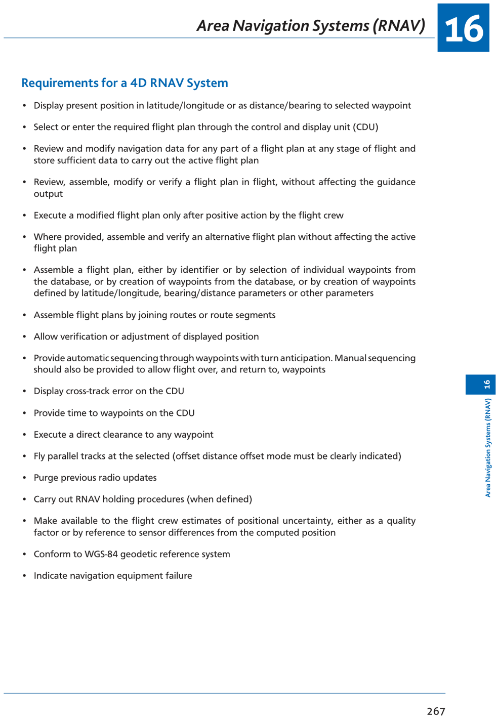
1. Introduction & Benefits 2. RNAV Types & Levels 3. Simple 2D RNAV System 4. Phantom Station (VORTAC RNAV) 5. Level 4 RNAV — FMS 6. CDU & FMC Pages 7. IRS/FMC Operation 8. Kalman Filtering 9. RNAV Summary 10. Practice Questions (15 Q)1. Introduction & Benefits
Area Navigation (RNAV) is a method of navigation that permits aircraft operations on any desired track within the coverage of ground-based navigation signals or within the limits of self-contained systems. Aircraft are no longer required to fly directly over ground beacons.
- Reduced distance, flight time, and fuel → lower costs
- Increased route capacity — more direct routes, parallel and bypass routes available
- Reduced vertical and horizontal separation criteria
- More flexible use of airspace — avoids congestion at beacon overhead positions
2. RNAV Types & Levels
| Type | Accuracy | Mandate |
|---|---|---|
| Basic RNAV (B-RNAV) | 5 NM on 95% of occasions | Mandatory for 30+ pax aircraft in Eurocontrol airspace |
| Precision RNAV (P-RNAV) | 1 NM on 95% of occasions | Required for P-RNAV terminal routes |
| Level | Capability |
|---|---|
| 2D RNAV | Horizontal plane only (lateral) |
| 3D RNAV | Horizontal + vertical (altitude guidance) |
| 4D RNAV | Horizontal + vertical + timing (RTA — Required Time of Arrival) |
3. Simple 2D RNAV System
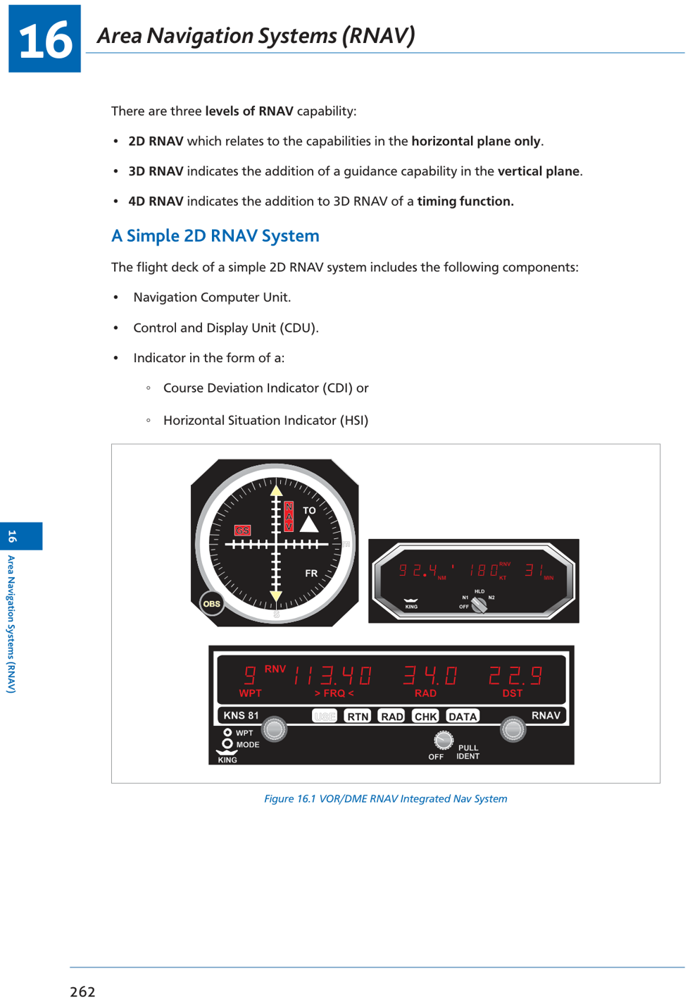
- Navigation Computer Unit: processes VOR/DME inputs to compute position
- Control and Display Unit (CDU): pilot enters waypoints; system computes tracking
- Indicator: CDI (Course Deviation Indicator) or HSI (Horizontal Situation Indicator) — both show deviation from computed track as if flying TO a waypoint
- Position accuracy limited by VOR/DME coverage and accuracy
- Cannot operate beyond LOS of VOR/DME stations
- Only horizontal guidance (2D) — no VNAV capability
- Limited to pre-set waypoints; no automatic flight phase management
4. Phantom Station (VORTAC RNAV)
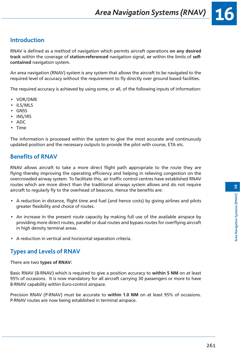
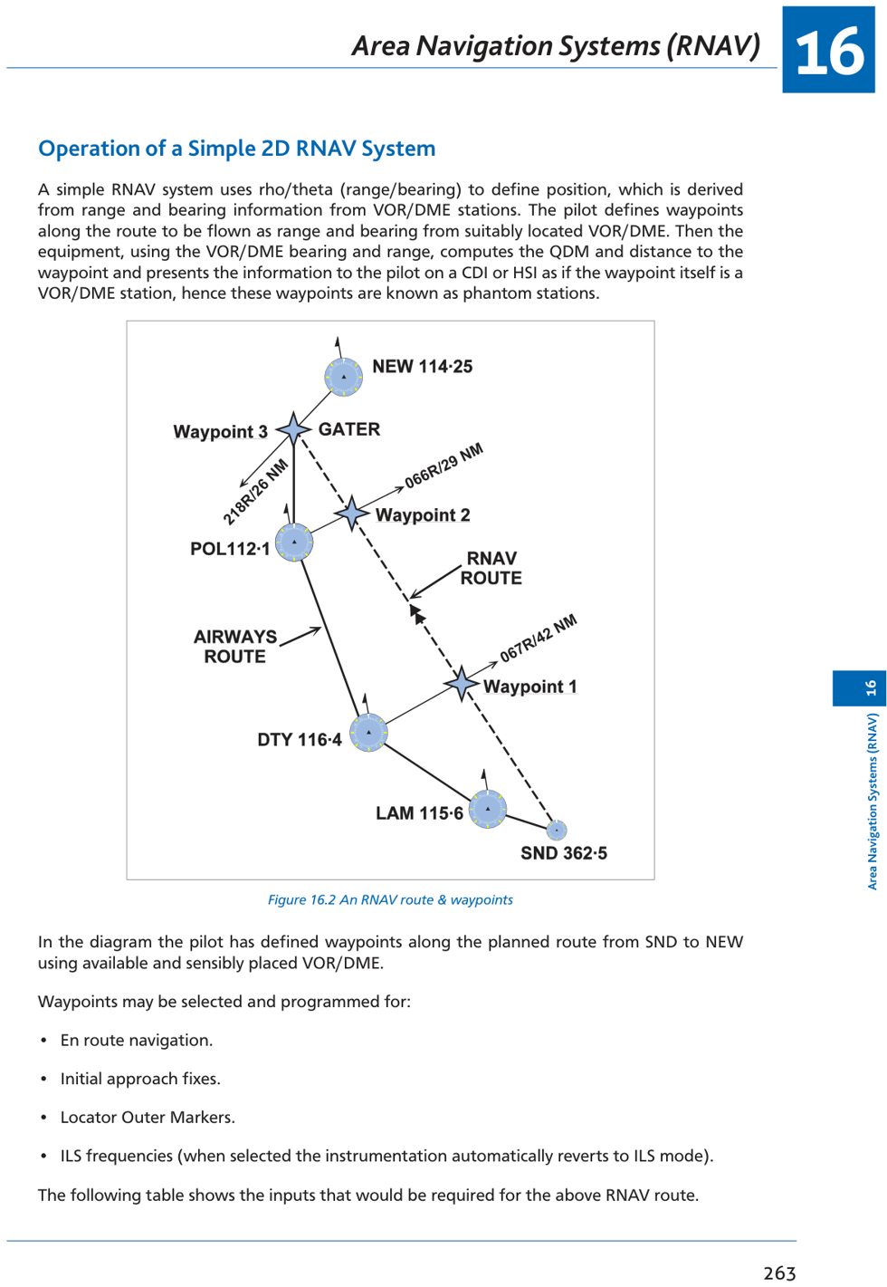
The RNAV computer calculates a phantom VOR/DME station (also called a waypoint) at a defined range and bearing from a real VOR/DME. The aircraft's CDI/HSI then indicates course and distance to this phantom station as if it were a real NAVAID.
- Pilot programs phantom station position as range & bearing from VOR/DME (rho/theta)
- Computer uses real VOR bearing (theta) and DME distance (rho) to calculate aircraft position
- Computes QDM and distance to phantom station (waypoint)
- Displays deviation from computed track on CDI/HSI
5. Level 4 RNAV — Flight Management System (FMS)
| Component | Function |
|---|---|
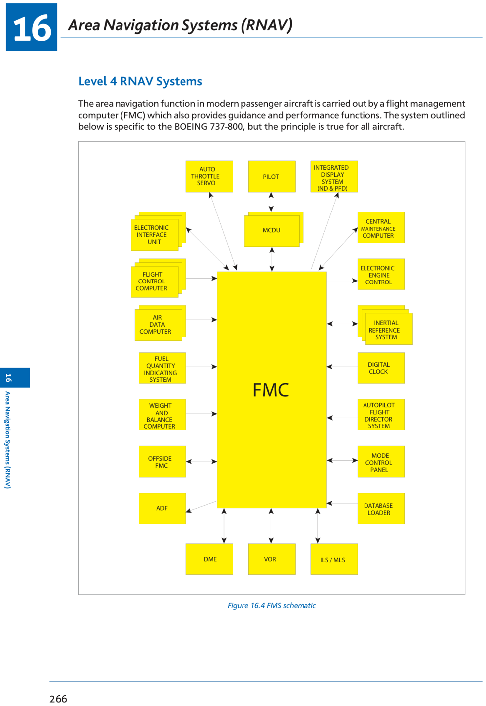
| FMC (Flight Management Computer) | Brain of FMS; processes navigation and performance data; calculates 4D trajectory |
| CDU (Control & Display Unit) | Pilot interface; alphanumeric keyboard + function keys + Line Select Keys (LSKs); scratchpad input |
| IRS (Inertial Reference System) | Self-contained position + attitude + groundspeed; degrades with time (drift) |
| External references | DME/DME, VOR/DME, GPS — FMC uses these to update IRS position |
| Performance database | Aircraft performance data for climb, cruise, descent optimization |
| Navigation database | Waypoints, airways, SIDs, STARs, airports — updated every 28 days |
- LNAV (lateral navigation): autopilot follows computed lateral track
- VNAV (vertical navigation): computed climb/cruise/descent profiles
- RTA (Required Time of Arrival): timing function for 4D flight profiles
- Continuous optimization: adjusts speed/altitude for best fuel economy or ATC-assigned RTA
- Automatic DME/DME, VOR/DME or GPS position updates to IRS
6. CDU Pages
| Page | Purpose | Key Inputs |
|---|---|---|
| IDENT | Verify aircraft/engine/database identity | Check nav data currency; update if required |
| POS INIT | Initialize IRS position & heading | Gate position or lat/long for IRS alignment; magnetic heading from standby compass |
| RTE | Input the route | Departure/destination airports, SID, airways, waypoints, runway |
| CLB/CRZ/DES | Review computed flight profiles | Check speeds, altitudes, restrictions, time/fuel predictions |
- 5 alphanumerics: named waypoints, VOR idents, airports (e.g. LOREL, TRN, EGLL)
- SID/STAR: up to 7 alphanumerics (e.g. TURN05)
- Lat/Long: N5000.0E00527.0 format
- Place/Bearing/Distance (PBD): TRN250.0/76 (bearing from TRN, 76 NM)
- Bearing/Bearing (BB): GOW167.0/TRN090.5 (intersection of bearings)
7. IRS/FMC Operation
- Left FMC: uses left IRS as primary + right IRS cross-check; updated by external references
- Right FMC: uses right IRS as primary + left IRS cross-check
- If one FMC fails: other FMC takes over all functions
- If both FMCs fail: IRS information fed directly to EFIS; no automatic performance management
- All three IRS positions compared → gross error detection → averaged
- Averaged position compared with external reference (DME/DME, VOR/DME or GNSS)
- Above 84° latitude: de-couple IRS — secant of latitude approaches infinity → longitude calculation degrades rapidly
8. Kalman Filtering
A mathematical algorithm that optimally combines multiple sensor inputs (IRS position/velocity + external DME/GPS fixes) with their known error characteristics to produce the best estimate of current position and velocity. It:
- Weights each input inversely proportional to its error variance
- Smooths noisy GPS/DME updates against more stable (but drifting) IRS data
- Produces a position estimate with lower error than any individual input
- Continuously updates the position estimate as new sensor data arrives
9. RNAV Summary
| Parameter | Detail |
|---|---|
| Definition | Navigation on any desired track within NAVAID coverage or self-contained system limits |
| B-RNAV | ±5 NM, 95% of occasions; mandatory 30+ pax in Eurocontrol |
| P-RNAV | ±1 NM, 95% of occasions; terminal routes |
| 2D RNAV | Lateral only; uses VOR/DME rho/theta; phantom station |
| 3D RNAV | + vertical guidance (VNAV) |
| 4D RNAV | + timing (RTA) |
| FMS | FMC + CDU + IRS + Nav/Perf Database; full 4D capability |
| Nav database update | Every 28 days (AIRAC cycle) |
| CDU sequence | IDENT → POS INIT → RTE → CLB/CRZ/DES |
| IRS de-coupling | Above 84° latitude (longitude error growth) |
| Kalman filtering | Optimally combines IRS + external references |
10. Practice Questions
P-RNAV requires position accuracy of 1 NM on 95% of occasions. B-RNAV requires 5 NM.
A basic 2D RNAV system uses VOR/DME (rho/theta — range and bearing) to define position and compute track to waypoints.
The DME display shows distance to the phantom station (waypoint), not the real VOR/DME. The aircraft is 20 NM from the phantom station → 20 NM.
Correct pre-flight sequence: IDENT → POS INIT → RTE. IDENT first to verify database, then position initialization, then route entry.
The IRS position can only be initialized on the ground. In flight, the FMC uses Kalman filtering with external references (DME/DME, GPS) to correct IRS drift, but the IRS itself is not manually updated in flight.
Select 3R to transfer gate position to scratchpad, then 4R to insert into IRS position field — this uses the most accurate database position.
The FMC uses the position from the selected IRS, processed by Kalman filtering and updated by external references (DME/DME, VOR/DME, GPS).
IRS drift accumulates over time. The position is most inaccurate at Top of Descent (TOD) — the end of a long cruise, furthest from the last IRS alignment. FMC tries to correct with DME/GPS updates.
Max 5 alphanumerics: navigation facilities (NAVAIDS), reporting points, and airways designators. SIDs/STARs use up to 7. Lat/long uses special format N5000.0E00527.0.
Pilots can read (interrogate) the database only. The database cannot be modified by pilots; it is updated by maintenance/data service providers every 28 days.
Above 84° latitude, the secant of latitude increases rapidly. Longitude calculations from the two IRS systems show increasingly different values → de-coupled mode prevents false gross error messages.
The B737-400 FMC uses VOR bearing up to 180 NM from the station. Beyond this range, bearing accuracy is insufficient for Kalman filtering updates.
The bearing/bearing (BB) format (e.g. GOW167.0/TRN090.5) IS a valid waypoint format. The format NOT available is bearing from two NAVAIDs as a simple format — the CDU uses only the BB format with specific syntax.
CDU latitude/longitude format: N5000.0E00527.0 — hemisphere prefix, degrees and decimal minutes, with decimal point mandatory.
The FMC navigation database is valid for 28 days (one AIRAC cycle). It must be updated every 28 days to remain current.
Chapter 16 — RNAV (Area Navigation Systems)
Ghost Aviator | www.ghostaviator.com
For personal study use only.
Reinforce Chapter 16: Area Navigation (RNAV)
Test your knowledge and practice actual exam questions for Radio Navigation.