Visibility and Fog
by Ghost Aviator
Table of Contents
1. Definition of Visibility
Night Definition: The greatest distance at which lights in the vicinity of 1,000 candela can be seen and identified against an unlit background.
In simple terms: The distance up to which prominent objects can be seen by naked eye and recognized as such under natural light.
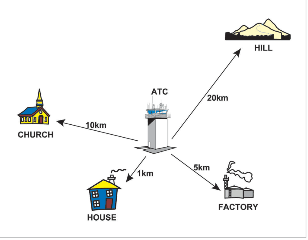
Visibility on the ground and from the air are of great importance to a pilot for landing and take-off. The pilot needs to see various land marks, targets, obstructions, beacon lights, other aircraft, runways etc., while in flight and during approach and landing. Poor visibility is a serious aviation hazard. Even at airfields where ILS is installed, a pilot would prefer better visibility conditions for safe landing and take-offs.
2. Visibility Reports & RVR
Visibility Reports
- The visibility reported by a Met Office is the lowest horizontal visibility at an airfield
- It may be different in different directions due to varying amounts of atmospheric obscurities
- This visibility may also differ from vertical and slant visibilities as estimated by an aircraft while in-flight
| Method | Daytime | Night-time |
|---|---|---|
| Estimation Method | Seeing runway markings and objects at pre-measured distances along the runway, within and around the airfield | From existing lights at known distances in and around the airport — called Visibility Land Marks |
Runway Visual Range (RVR)
- RVR equipment installed along various runways, close to the take-off and landing areas
- RVR is reported when the visibility is less than 1500 m
- RVR 2000 and 1500 are included in METAR as supplementary information
- RVR 2000 and 1500 are NOT disseminated internationally
3. Causes of Poor Visibility
| Obscurity | Definition | Visibility | Special Notes |
|---|---|---|---|
| Haze | Suspension of very small particles of smoke, dust, water, etc. Gives a milky appearance | ≤5000 m | — |
| Dust Haze | Dust kicked up by strong winds, especially in desert/semi-arid areas; suspended in air; causes Dust Haze. Summer hazard. Thicker during day. | Widely reduced; diversionary hazard | Extends from Rajasthan to Punjab, Haryana, UP, Bihar; vertically may extend 6–8 km |
| Smoke Haze | From industrial/domestic sources; spreads as haze layer, especially when wind is calm or very light and strong ground inversion | Widely reduced | — |
| Mist | Suspension of water droplets in atmosphere | ≥1000 m but ≤5000 m | RH is almost 100% |
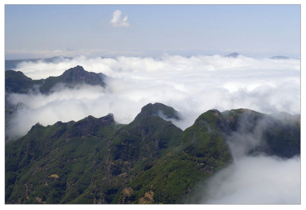
| Fog | Suspension of water droplets or ice crystals; RH ~100% | <1000 m | Classified as: Thick, Moderate, Light. Fog is the cloud sitting on ground. |
| Smog | When fog and smoke co-exist | Very poor | Severely limits visibility; health hazard |
| Dust Storm | — | ≤5000 m | If followed by rain visibility improves fast |
| Sea Spray | Under favourable wind conditions, salt particles sprayed from wave crests; water drops form; thin layer at low level and on wind screen | Considerable reduction | In rare cases reduces forward visibility to almost zero on wind screen; also during monsoons and cyclones |
| Volcanic Ash (VA) | Solid matter from volcanoes; carried by winds; suspended for long time | Surface and in-flight: almost nil | Severely damages engine and other aircraft parts. Indian Volcano: Barren Island (12.16N 93.51E) — first erupted 1787, most recent 2020. Baratang Island lies 150 km N of Port Blair. |
| Precipitation | Rain, showers, drizzle, snowfall | Variable (see table below) | — |
Visibility in Precipitation
| Precipitation Type | Intensity | Visibility |
|---|---|---|
| Rain | Moderate | 1–3 km |
| Rain/Showers | Heavy | <1000 m |
| Drizzle | Any | <1000 m |
| Snow | Any | may fall <1000 m |
Indian context: Barren Island (12.16N 93.51E) — first erupted 1787, most recent 2020. Baratang Island (mud volcano) is 150 km N of Port Blair.
flowchart TD
    PV["CAUSES OF POOR VISIBILITY"] --> H["Haze ≤5000m\n(smoke/dust/water)"]
    PV --> DH["Dust Haze\n(desert storms, summer)"]
    PV --> SH["Smoke Haze\n(industrial, inversion)"]
    PV --> M["Mist 1000-5000m\nRH~100%"]
    PV --> F["FOG <1000m\nRH~100%"]
    PV --> DS["Dust Storm ≤5000m"]
    PV --> SS["Sea Spray\n(coastal, thin layer)"]
    PV --> VA["Volcanic Ash\n(almost nil, engine damage)"]
    PV --> P["Precipitation\n(1-3km mod rain,\n<1km heavy/drizzle/snow)"]
    F --> RF["Radiation Fog"]
    F --> AF["Advection Fog"]
    F --> STF["Steaming Fog"]
    F --> FF["Frontal Fog"]
    F --> UF["Upslope Fog"]
    F --> IF["Inversion Fog"]
4. Vertical and Slant Visibility
- Vertical Visibility may be good
- Slant Visibility is poor
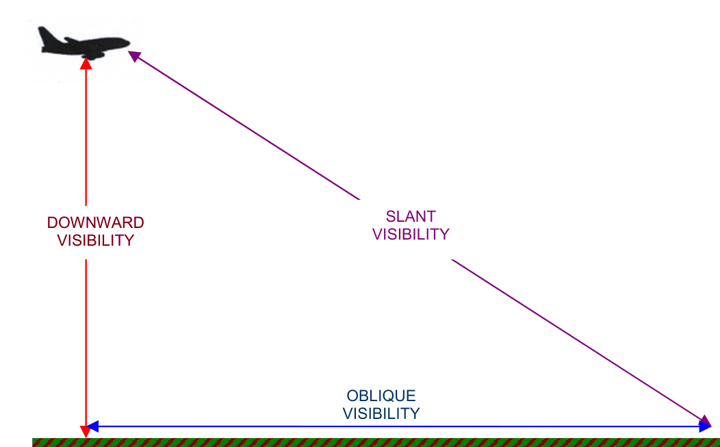
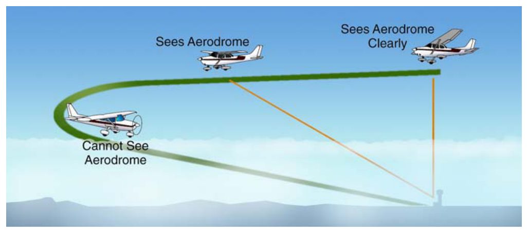
As one goes higher and higher, the transparency of the atmosphere increases considerably, except in cloud and precipitation. Visibility is lower looking towards the sun due to reflection of the moon light (also applies to looking towards the sun during daytime).
5. Instruments for Measuring Visibility
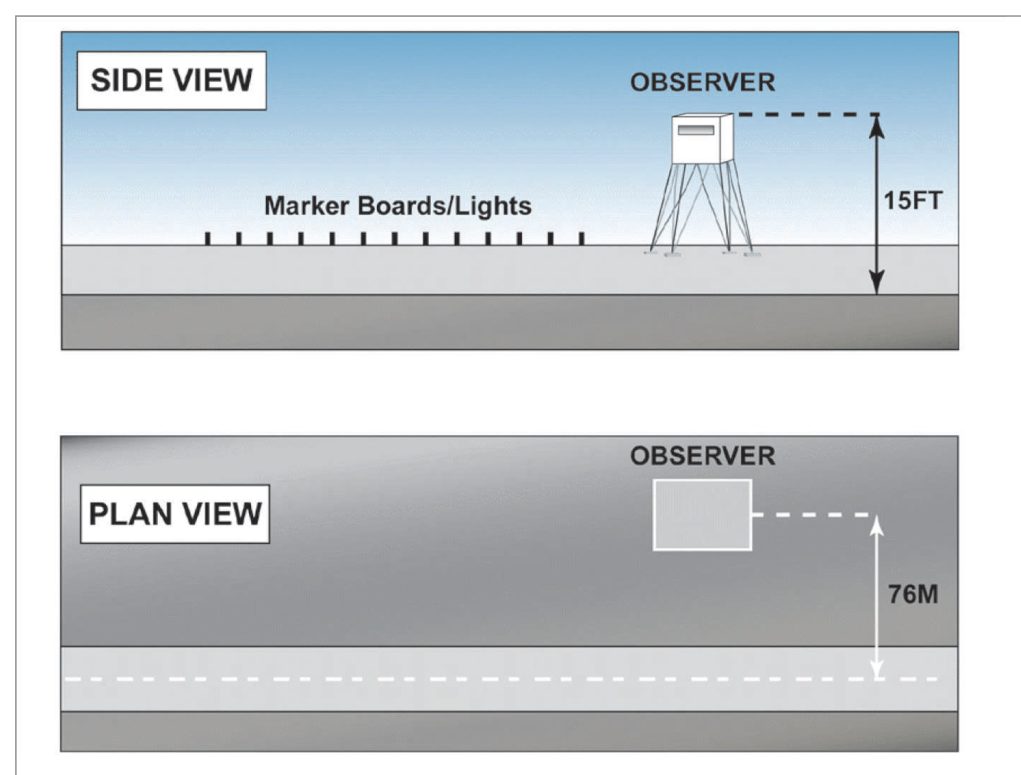
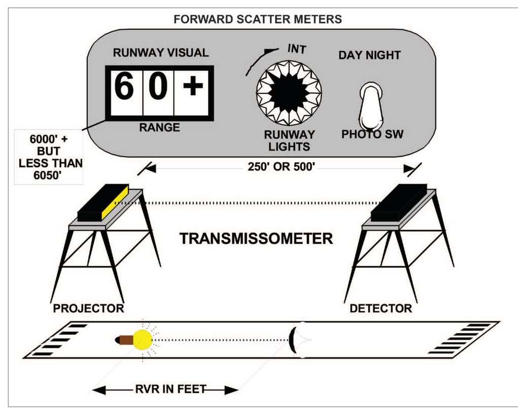
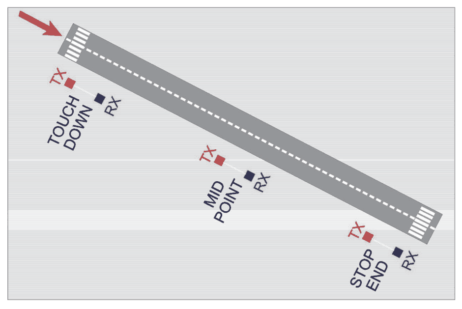
- At some Indian Met Offices: Automatic Visual Range Assessor (AVRA) is used for measuring RVR
6. Types of Fog
6.1 Radiation Fog
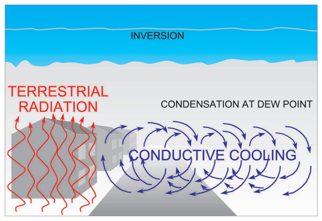
Favourable Conditions for Radiation Fog Formation
| Condition | Reason |
|---|---|
| (a) High Relative Humidity | Little cooling needed to reach dew-point; condensation of water vapour can occur |
| (b) Clear Sky | Clear skies permit maximum nocturnal cooling of ground and adjacent air layers |
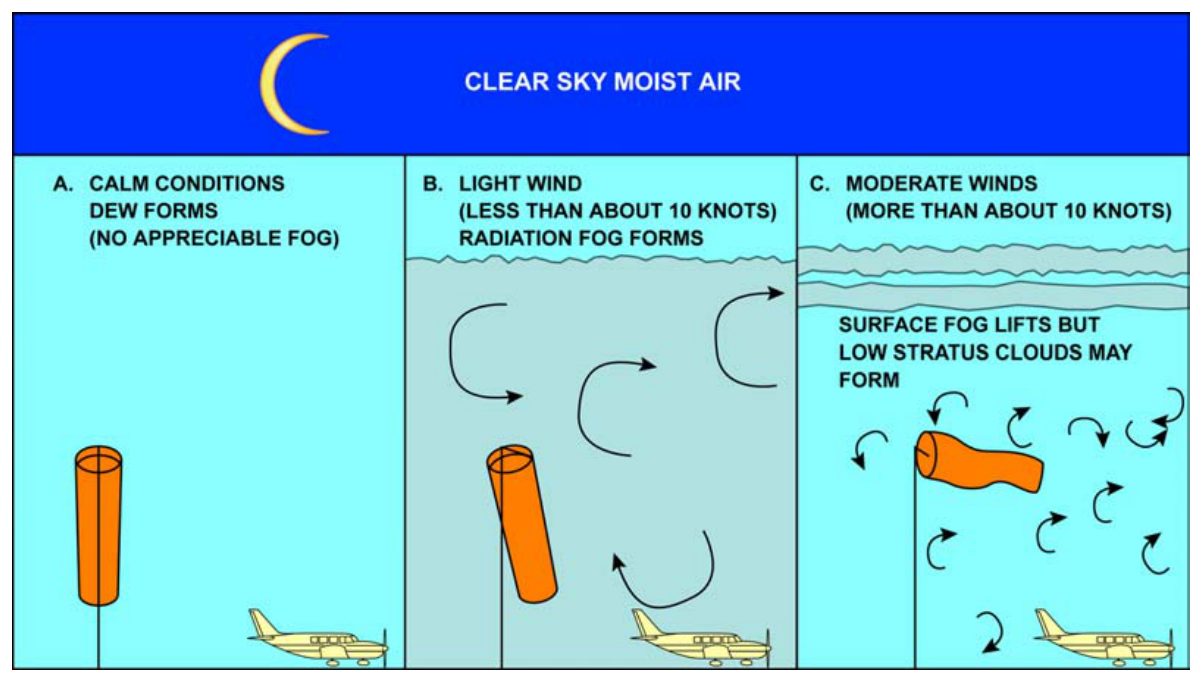
| (c) Light Wind: 3–7 kt | Enables turbulent mixing and cooling of layers close to ground; brings their temperature to dew-point |
| (d) Stability | Generally stable atmosphere, so mixing and cooling are confined to a shallow layer |
Why Strong Wind Can Prevent Radiation Fog: Turbulence prevents cooling any one layer enough; cooling spreads over too thick a layer and temperature doesn't fall to dew point.
Characteristics of Radiation Fog
- Forms in anticyclones, ridges, and ground inversions — wind is light, skies are clear, atmosphere stable
- Fog would form even when RH is less than 100% due to hygroscopic condensation nuclei
- Minimum temperature usually occurs just after sunrise
- Most frequent at about sunrise or it thickens at that time
- Radiation fog dissipates about 2–3 hours after sunrise due to heating
- If deep, sun's heat takes longer to penetrate ground; fog may persist to midday
- Usually lifts into low stratus clouds before finally dissipating
Radiation Fog in India
- A winter hazard in India
- Usually forms after the passage of a Western Disturbance (WD) which caused rain and then sky cleared
- Almost a daily feature in winters in the valley of the Brahmaputra river where adequate moisture is present
- Katabatic flow provides the required turbulence and additional cooling
- Most susceptible areas: NW India, UP, Bihar, Jharkhand, Chhattisgarh, Bengal and Assam (particularly Southern banks of Brahmaputra river)
- Vertical extent: Few hundred feet to 1500 ft, maximum 1 km
- Upper surface of vertical radiation fog is sharp with clear air above
- Pressure system: A High or Col with weak pressure gradient is favourable; fog does NOT form when pressure gradient is steep and low level winds are strong
6.2 Advection Fog
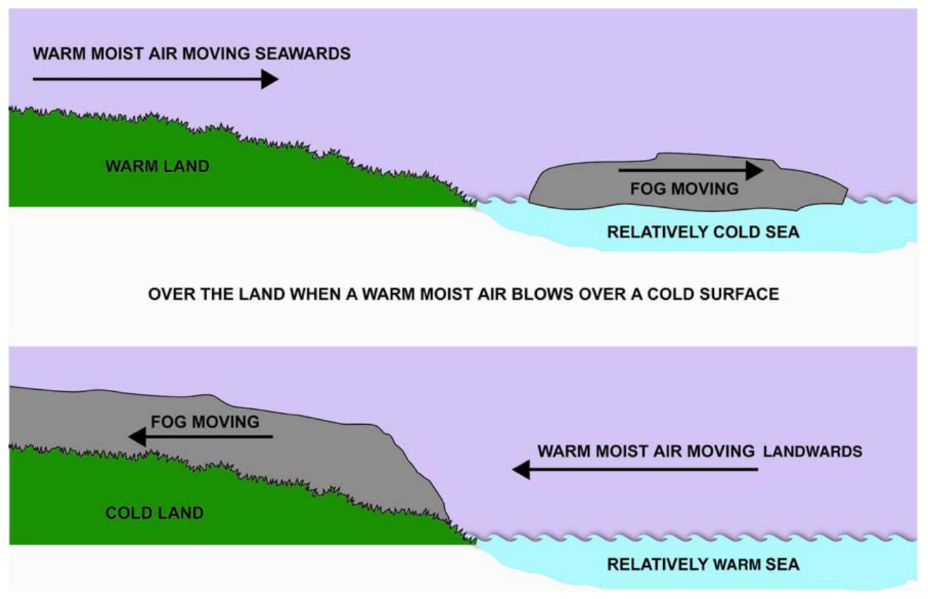
- Coastal fogs of Bengal and Orissa in winters are due to a combined effect of advection and radiation
- Advection fog forms any time of day and night
- More persistent than radiation fog and more extensive
- Common over sea in spring when warm air moves over cooler sea water
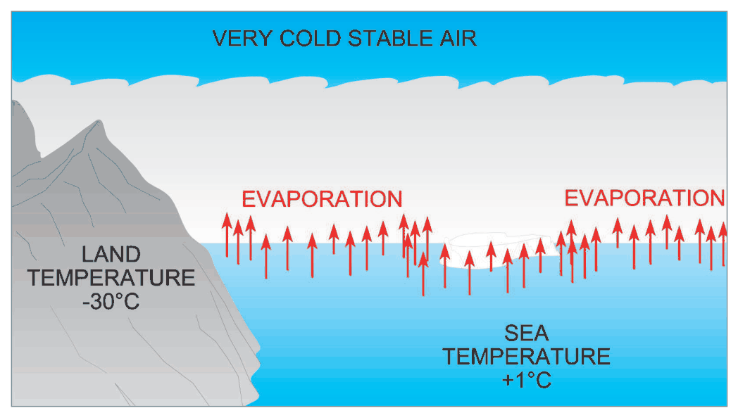
6.3 Steaming Fog (Sea Smoke)
- Common in Icelandic and Norwegian regions
- Over sea, often referred to as sea smoke
6.4 Frontal Fog
6.5 Upslope Fog
6.6 Inversion Fog
Fog Types — Comparison Table
| Fog Type | Cause | Time | Location | Key Characteristic |
|---|---|---|---|---|
| Radiation | Nocturnal cooling; radiation loss | Night → morning | Land; valleys, depressions | Clear sky + light 3-7kt wind required; dissipates 2-3hr after sunrise |
| Advection | Warm moist air over cold surface | Day or Night | Land and sea coasts | More persistent; can be thick; Bengal/Orissa coastal fogs in winter |
| Steaming (Sea Smoke) | Cold air over warm sea | Any time | High latitude seas | Looks like steam; Iceland/Norway |
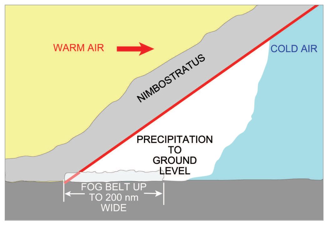
| Frontal | Rain ahead of front saturates air; cloud lowers to surface | With frontal passage | Frontal zones | Associated with Western Disturbances; common with Cold Fronts |
| Upslope | Moist air lifts along slope; adiabatic cooling | Any | Hill slopes, plains | — |
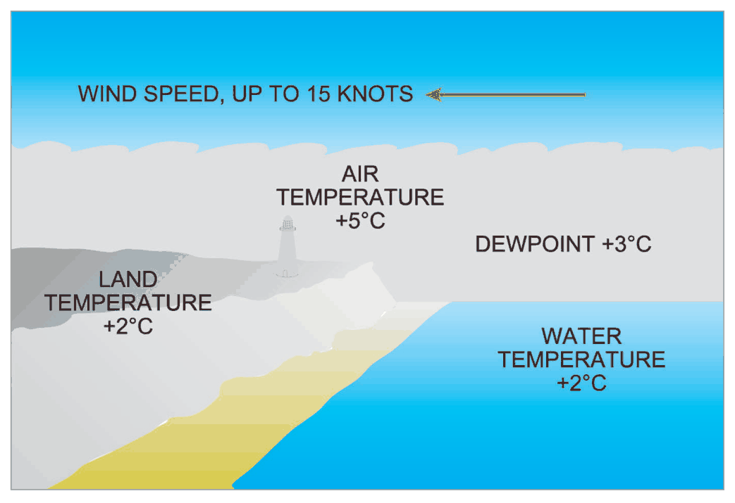
| Inversion | Subsiding cold air meets warm water body | Any | Anticyclonic areas; coasts | In anticyclone with temperature inversion |
flowchart LR
    subgraph Formation
    A["Clear night\n+ High RH\n+ 3-7kt wind\n+ Stable air"] --> RF["RADIATION FOG\n(most common in India)"]
    B["Warm moist air\ntransported over\ncold surface"] --> AF["ADVECTION FOG\n(land + sea, day/night)"]
    C["Cold air over\nwarm sea"] --> STF["STEAMING FOG\n(Sea Smoke)"]
    D["Rain ahead of front\nor cloud lowering"] --> FF["FRONTAL FOG"]
    E["Moist air lifted\nalong slope"] --> UF["UPSLOPE FOG\n(Adiabatic cooling)"]
    F["Subsiding cold air\n+ warm water body"] --> IF["INVERSION FOG\n(Anticyclone)"]
    end
7. Fog Dispersal
Thermal Method
When air is heated to temperature above the dew point, fog or clouds will dissipate. During the Second World War, heaters, burners, fires were used to disperse fog but the method involved large expenditures and was discontinued.
Use of Hygroscopic Nuclei
When hygroscopic particles are injected into fog water drops form. This lowers the RH of the air, leading to dissipation of fog. Seeding with dry ice or silver iodide or propane gas produces freezing and precipitation.
1. Thermal Method — heat air above dew point (expensive, discontinued after WWII)
2. Hygroscopic Nuclei / Cloud Seeding — dry ice, silver iodide, propane gas → freezing and precipitation → lowers RH → fog dissipates
Practice Q&A — Chapter 7: Visibility and Fog
(a) Less than 1000m (b) 1000m (c) 1000 to 2000
❌ (c) 1000-2000m: This is the Mist range.
(a) 500m (b) 1000m (c) 1500m (d) 2000m
(a) Over land (b) Over sea (c) During day
❌ (c) During day: Radiation fog forms at night and persists until morning; daytime heating dissipates it.
(a) Mist (b) Haze (c) Fog
❌ (c) Fog: Fog is visibility <1000m.
(a) May to June (b) Dec to Feb (c) Oct to Nov
❌ (c) Oct to Nov: Transition season; not the primary radiation fog season.
(a) Thunder clouds (b) Fog and stratus (c) Frontal clouds
❌ (c) Frontal clouds: These require frontal lifting.
(a) WD (b) Depression (c) Col
❌ (c) Col: Col can be favourable but WD is specifically mentioned in the text as the trigger.
(a) Heating of the earth during day
(b) Radiational cooling of earth at night
(c) Advection of cold air
❌ (c) Advection of cold air: That is Advection Fog mechanism (warm moist air over cold surface).
(a) Nocturnal (b) Dusk (c) Day
(a) Water (b) Land (c) Both
(a) Radiation (b) Advection (c) Frontal
❌ (c) Frontal: Frontal fog = saturation from rain ahead of front or cloud lowering.
(a) Radiation (b) Advection (c) Frontal
(a) Night only (b) Day time only (c) Any time of day and night
❌ (b) Daytime only: No fog type is daytime-only.
(a) There should be sufficient moisture in atmosphere, cloudy sky, nil wind
(b) There should be sufficient moisture in atmosphere, clear sky, light wind
(c) There should be sufficient moisture in atmosphere, cloudy sky, strong wind
❌ (c) Cloudy sky, strong wind: Cloudy sky prevents cooling; strong wind mixes fog away or too thick a layer cooled.
(a) Viscometer (b) Transmissometer (c) Ceilometer
❌ (c) Ceilometer: Measures cloud base height, not visibility.
(a) Over sea (b) Over land (c) Both over land and sea
(a) Stratus (b) Strato cumulus (c) Nimbostratus
❌ (c) Nimbostratus: Rain-bearing grey layer cloud at significant height.
(a) Isothermal (b) Adiabatic (c) Inversion (d) SALR
❌ (b) Adiabatic: Adiabatic process relates to rising/sinking air — upslope fog only.
❌ (d) SALR: Saturated adiabatic lapse rate is about in-cloud processes.
Master Reference Tables — Chapter 7: Visibility and Fog
Key Numerical Values
| Parameter | Value |
|---|---|
| Fog: visibility threshold | <1000 m |
| Mist: visibility range | ≥1000 m but ≤5000 m |
| Haze: visibility | ≤5000 m |
| Dust Storm visibility | ≤5000 m |
| RVR reporting trigger | <1500 m |
| RVR in METAR (supplementary) | 2000 and 1500 m (not disseminated internationally) |
| Mist: RH | ~100% |
| Fog: RH | ~100% |
| Favourable wind for radiation fog | 3–7 kt |
| Radiation fog dissipation after sunrise | ~2–3 hours |
| Radiation fog vertical extent | few hundred feet to 1500 ft (max 1 km) |
| Dust Haze vertical extent | 6–8 km |
| Visibility in moderate rain | 1–3 km |
| Visibility in heavy rain/drizzle/snow | <1000 m |
| Barren Island (Indian volcano) position | 12.16N 93.51E |
| Barren Island first eruption | 1787 |
| Barren Island most recent eruption | 2020 |
| Baratang Island distance from Port Blair | 150 km N |
Fog Formation Conditions Summary
| Fog Type | Key Conditions | Time | Indian Context |
|---|---|---|---|
| Radiation | High RH + Clear sky + 3-7kt wind + Stability + Anticyclone/Ridge | Night → AM | NW India, UP, Bihar, Jharkhand, Chhattisgarh, Bengal, Assam; after WD; Dec-Feb |
| Advection | Warm moist air + Cold surface (land or sea) | Any | Bengal/Orissa coastal (advection + radiation) |
| Steaming | Cold air over warm sea | Any | Not common; high latitude seas |
| Frontal | Continuous rain ahead of front; cloud lowers to surface | With front | With Cold Fronts and WD |
| Upslope | Moist air + slope + lifting + adiabatic cooling | Any | Hill stations, plains adjacent to hills |
| Inversion | Anticyclonic subsidence + warm water body + cold air | Any | Coastal anticyclonic areas |
Visibility Obscurity Classification
| Obscurity | Visibility | Composition | RH |
|---|---|---|---|
| Haze | ≤5000m | Smoke, dust, water particles | Variable; milky appearance |
| Dust Haze | Widely reduced; diversionary | Dust from desert/semi-arid | Variable; summer |
| Smoke Haze | Widely reduced | Industrial/domestic smoke | Variable; stable/inversion |
| Mist | ≥1000m, ≤5000m | Water droplets | ~100% |
| Fog | <1000m | Water droplets or ice crystals | ~100% |
| Smog | Very poor | Fog + smoke | ~100% + pollutants |
| Dust Storm | ≤5000m | Dust particles | Low |
| Sea Spray | Variable; almost nil at windscreen | Salt particles, water drops | High |
| Volcanic Ash | Almost nil | Solid volcanic particles | Variable |
Quick Revision Summary — Chapter 7
Definitions: Fog <1000m; Mist 1000–5000m; Haze ≤5000m (all RH); Smog = fog+smoke
RVR: Reported when viz <1500m. Instrument = Transmissometer/Scopograph. AVRA at some Indian Met Offices.
Radiation Fog: Night cooling + Clear sky + 3-7kt wind + High RH + Stability → land only; After WD in India; NW India/UP/Bihar/Jharkhand/Chattisgarh/Bengal/Assam; Lifts 2-3hr after sunrise; Top sharp; Ext: few 100ft to 1500ft max 1km
Advection Fog: Warm moist air over cold surface; land + sea; day or night; Bengal/Orissa coastal (advection+radiation)
Steaming Fog: Cold air over warm sea; Iceland/Norway
Frontal Fog: Cold Front rain saturation / cloud lowers to surface
Upslope: Adiabatic cooling on slope
Inversion: Anticyclone + cold air + warm water
Dispersal: Thermal (discontinued, expensive) or Seeding (dry ice, AgI, propane)
VA: Barren Island (12.16N 93.51E); first erupted 1787; last 2020; Baratang = 150km N Port Blair
Reinforce Chapter 7: Visibility and Fog
Test your knowledge and practice actual exam questions for Aviation Meteorology.