Winds
by Ghost Aviator
Table of Contents
- 1. Wind Measurement & Cross Wind
- 2. Gust, Lull, Squall & Gale
- 3. Backing & Veering — Buys Ballot's Law
- 4. Forces Acting on Wind — Coriolis Force
- 5. Types of Calculated/Balanced Winds
- 6. Effect of Surface Friction & Turbulence
- 7. Wind Shear (WS)
- 8. Local Winds Due to Topography
- 9. Thermal Wind & Contours
- 10. Vorticity
- 11. Names of Winds of the World
- 12. Beaufort Force Scale
- Practice Q&A (45 Questions)
- Master Reference Tables
1. Wind Measurement & Cross Wind
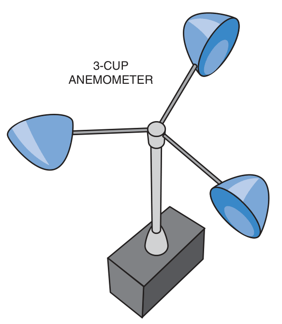
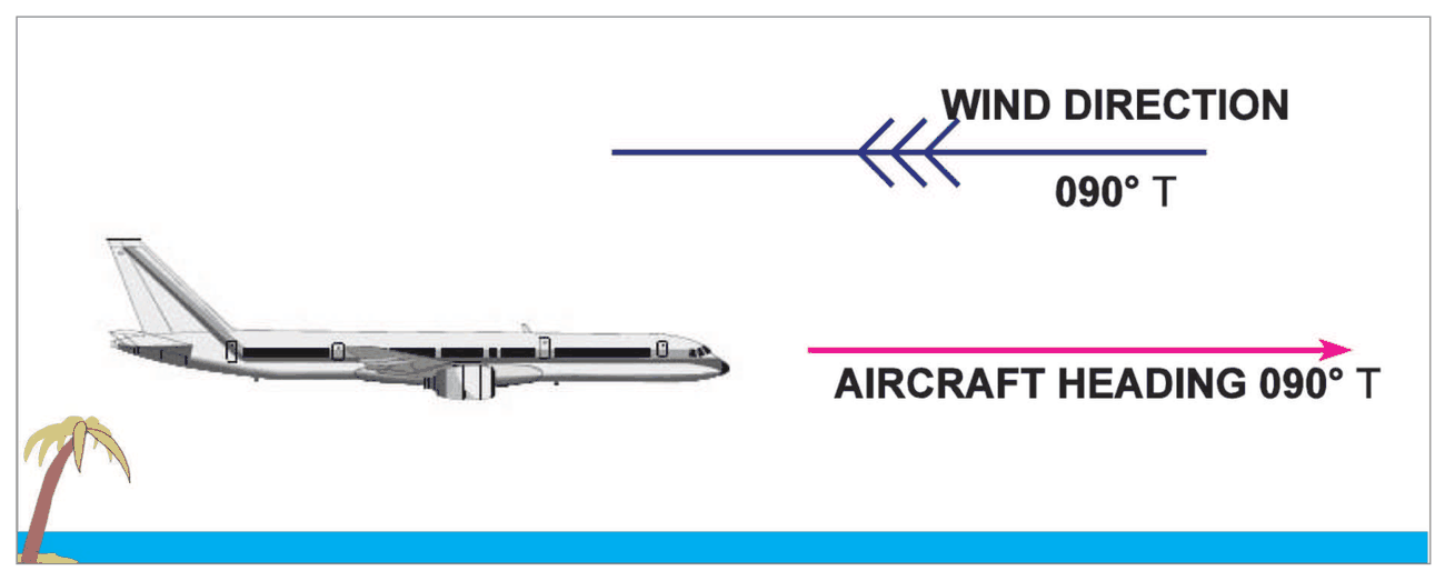
Cross Wind
Runways are oriented along the most prevailing wind directions of a locality based on climatological records. Sometimes — especially during adverse weather and transition seasons — the winds deviate from these directions. A wind 90° to the runway in use is called the Cross Wind Component. Critical cross wind components for each type of aircraft are specified. Cross winds tend to swing the aircraft during take-off and landing, especially lighter aircraft.
Instruments for Measuring Wind
- Surface wind speed: Measured by Anemometer
- Wind direction: Measured by Wind Vane
- Upper winds: Measured by RAWIN and Pilot Balloon equipment
- Hydrogen-filled balloons: Tracked by RADAR and Optical Theodolite
Exposure of Wind Instruments
- Anemometer and Wind Vane installed at height of 10 m in area free of obstructions
- Averaged over 10 minutes for all weather observations
- For take-off and landing purposes: wind is averaged for 2 minutes
2. Gust, Lull, Squall & Gale
Lull: A negative fluctuation in wind (below mean).
Squall
- Associated with CB clouds and violent convective activity
- Extends some km horizontally and several thousands of feet vertically
- Both speed and direction in squall may differ widely from prevailing winds
- Violent squalls experienced in Norwesters, Thunderstorms (TS) and Duststorms (DS) from March to June
- Line squalls occur ahead of Cold Fronts and sometimes with Norwesters
Gale
flowchart LR
    A["Wind Fluctuation"] --> B{Duration?}
    B -->|"Few seconds"| C["GUST\n(Positive fluctuation)"]
    B -->|"Negative fluctuation"| D["LULL"]
    B -->|"≥1 min, ↑32kmh→44kmh"| E["SQUALL\n(CB associated)"]
    A --> F{Speed ≥34kt persistent?}
    F -->|Yes| G["GALE\n(Depressions/Cyclones)"]
3. Backing & Veering — Buys Ballot's Law
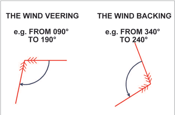
Backing and Veering
| Term | Definition | Example |
|---|---|---|
| Backing | Change of wind direction anti-clockwise | 090° → 060° or 270° → 160° |
| Veering | Change of wind direction clockwise | 060° → 090° |
In a high pressure area: Wind blows clockwise (Veers) in N hemisphere.
Buys Ballot's Law (Pressure and Wind)
- N hemisphere: wind blows anti-clockwise around a cyclone (Low) and clockwise around an anti-cyclone (High)
- S hemisphere: opposite sense
4. Forces Acting on Wind — Coriolis Force
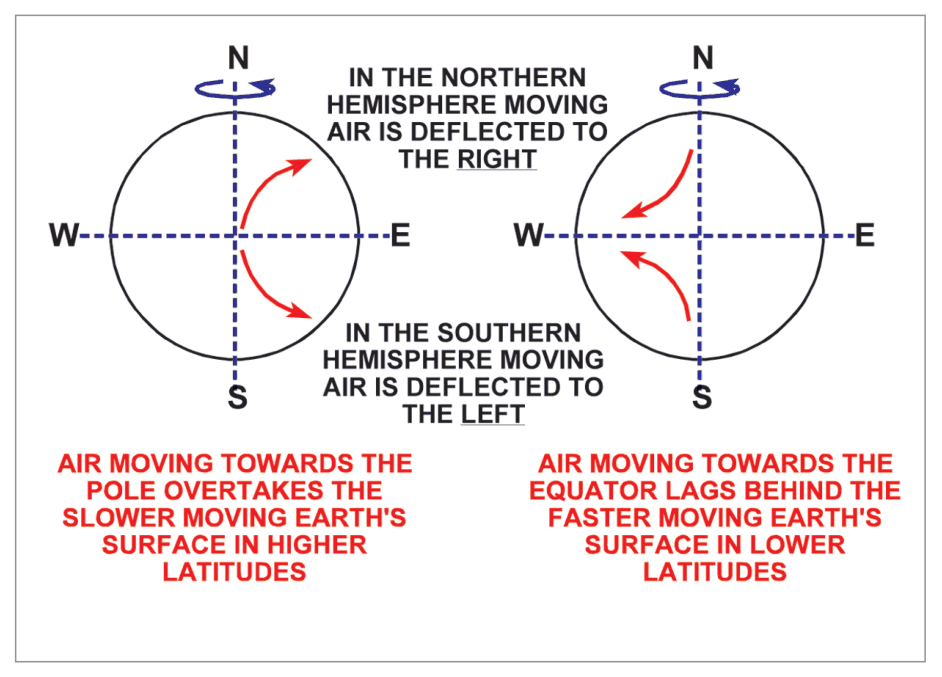
Coriolis Force (f)
Ω = angular velocity of Earth (unaffected by frictional forces)
ρ = density (unit volume of air, magnitude = 2ρV sin φ)
V = wind speed
φ = latitude
At poles: φ = 90°, sin φ = 1 → Coriolis force MAXIMUM
At equator: φ = 0°, sin φ = 0 → Coriolis force ZERO (minimum)
Coriolis force is directly proportional to wind speed and air density. Acts perpendicular to the wind direction.
- Acts perpendicular to the wind direction — does NO work on air
- Zero at equator — geostrophic formula breaks down
- Maximum at poles
- Deflects to the RIGHT in N hemisphere, LEFT in S hemisphere
- Also called the Geostrophic Force — it is an apparent force
5. Types of Calculated/Balanced Winds
flowchart TD
    A["FORCES ON WIND"] --> B["Pressure Gradient (P)"]
    A --> C["Coriolis (f)"]
    A --> D["Centripetal (C)"]
    A --> E["Friction (F)"]
    A --> F["Isallobaric Force"]
    B & C --> G["GEOSTROPHIC WIND\n(P = f)\nStraight isobars only"]
    B & C & D --> H["GRADIENT WIND\n(P + f + C)\nCurved isobars"]
    B & C & D & E --> I["ACTUAL SURFACE WIND\n(Friction layer)"]
    C & D --> J["INERTIAL WIND\n(f + Centrifugal)\nVi = fR"]
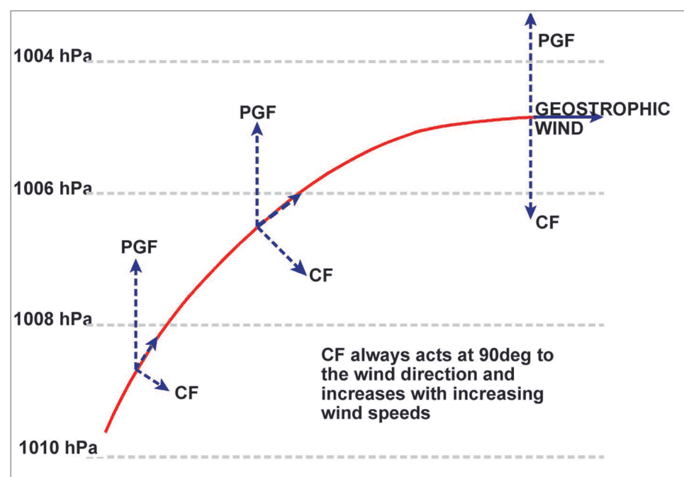
Geostrophic Wind (Vg)
Where P/ρ = pressure gradient per unit mass
Closer isobars → stronger wind (inversely proportional to spacing)
- Valid only when PGF and Coriolis are in balance and isobars are straight & parallel
- The geostrophic approximation fails near the Equator, where Coriolis is weak. It also requires negligible friction, nearly steady conditions and straight, parallel isobars; it does not automatically fail at the poles.
- Winds like gusts, squalls, local winds, and sea breezes do NOT follow this rule
- Geostrophic wind differs in direction and speed from actual wind (especially middle latitudes)
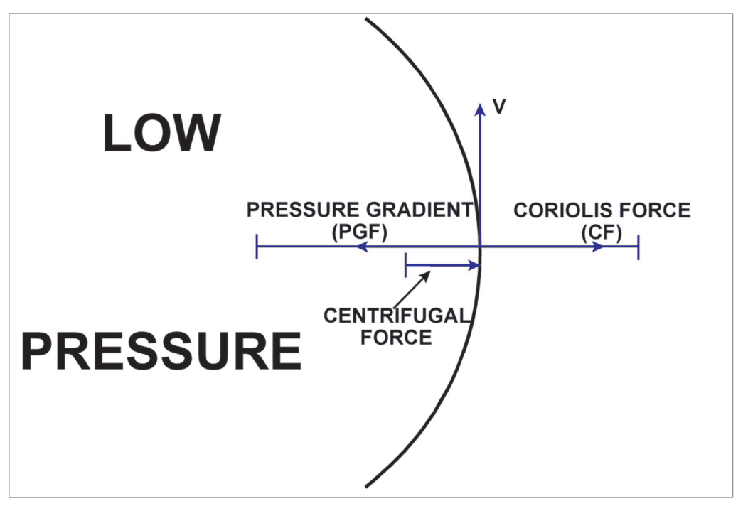
Cyclostrophic Wind
A useful approximation for some tightly curved flows, including tornadoes, where Coriolis is small relative to the pressure-gradient and curvature terms. The balance does not require anticyclonic rotation.
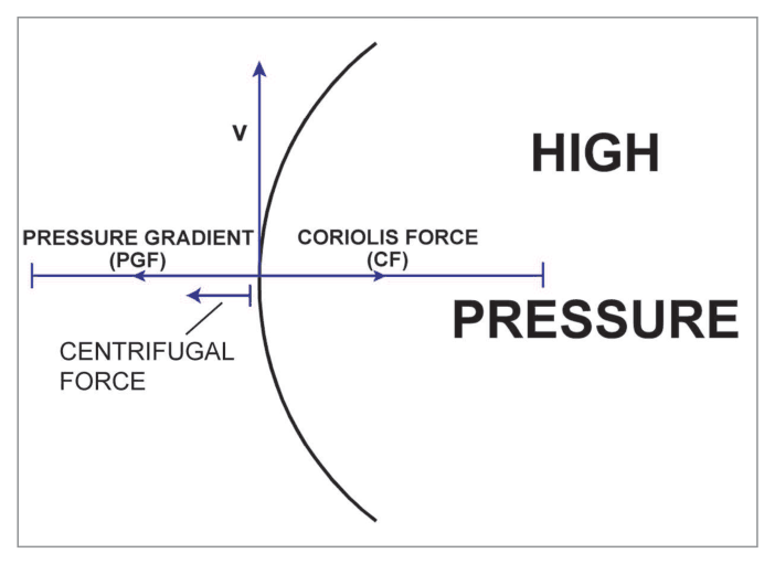
Gradient Wind
| System | Balance | Result |
|---|---|---|
| Cyclone (Low) | P = f + C, with C denoting centrifugal force | Sub-geostrophic (V < Vg) |
| Anticyclone (High) | f = P + C, with C denoting centrifugal force | Super-geostrophic (V > Vg) |
Isallobaric Wind
When pressure changes rapidly, geostrophic and gradient rules do not apply. An additional force called Isallobaric Force comes into play, directed from higher isallobar to lower isallobar, deflecting wind towards falling pressure. The resulting wind is the Isallobaric Wind.
Inertial Wind
f = Coriolis Force, R = radius of curvature (1/radius of path)
The constant Inertial wind speed is Vi.
The inertial flow is Anticyclonic in BOTH hemispheres.
Geostrophic = P↔f (straight isobars) | Cyclostrophic = P↔Centripetal (near equator, curved) | Gradient = P↔f↔C (curved, mid-lat) | Isallobaric = rapid pressure change | Inertial = f↔Centrifugal (no PGF)
6. Effect of Surface Friction & Turbulence
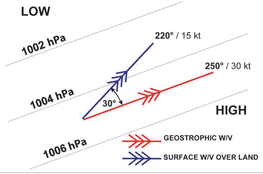
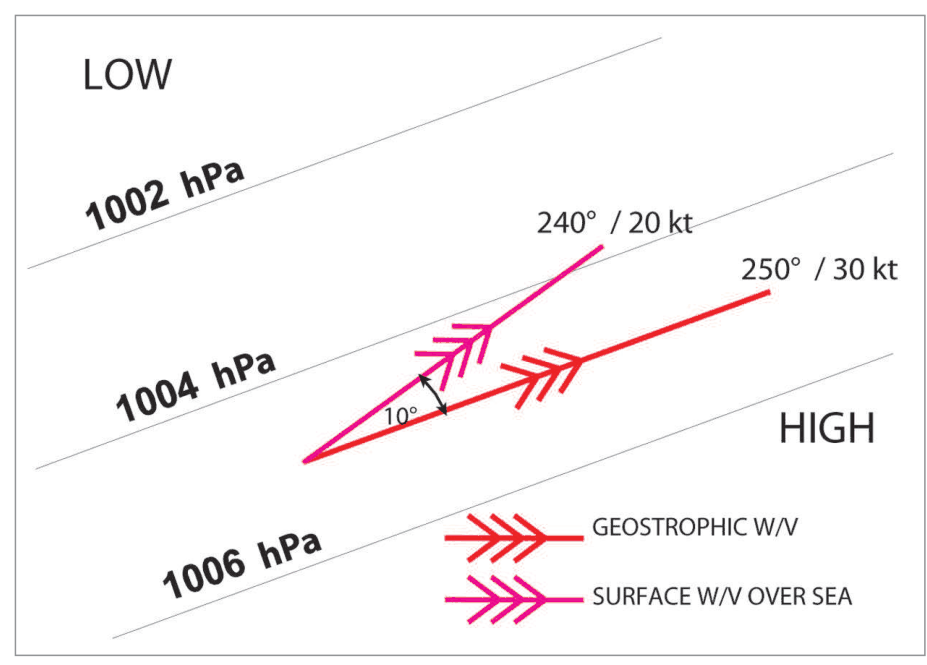
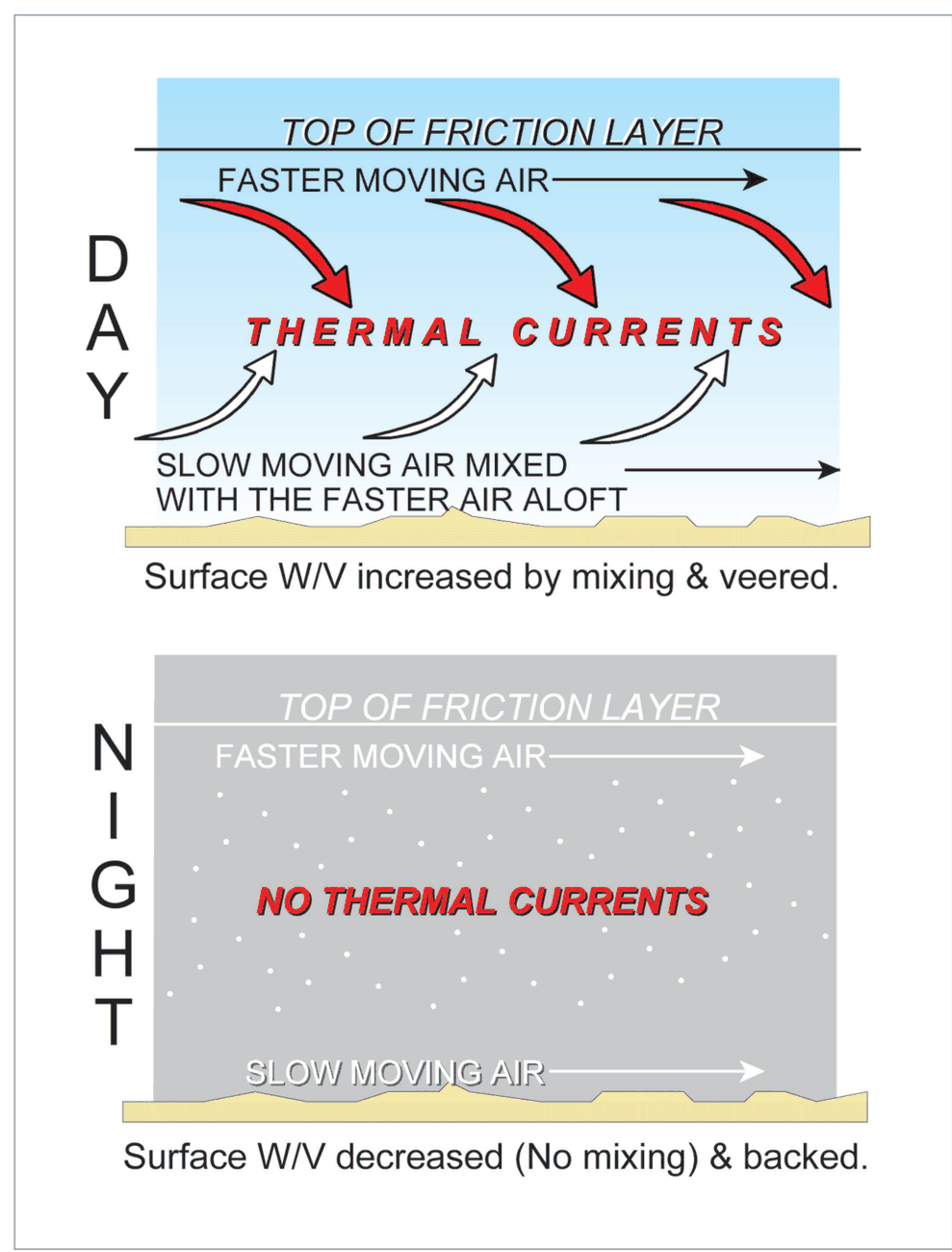
Friction Layer
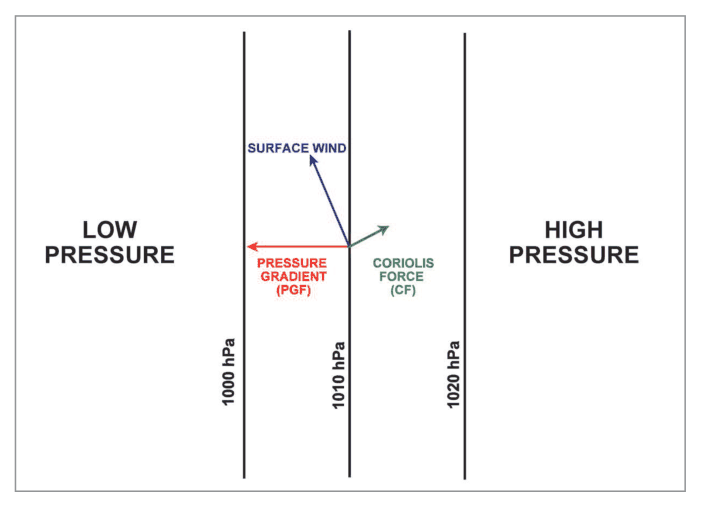
- The rough earth causes friction, affecting the atmosphere up to about 1 km
- This layer is called the Friction Layer; thickness is variable
- Within friction layer: wind slows down → Coriolis reduces → insufficient to balance PGF → wind is deflected towards low pressure → flow becomes cross isobaric
| Surface | Inclination to Isobars | Speed (of Vg) |
|---|---|---|
| Over Sea | ~15° | ~2/3 Vg |
| Over Land | ~30° | 1/3 to 1/2 Vg |
Turbulence and Gustiness
- Wind is seldom steady; peak fluctuations = Gusts, lowest = Lulls
- Width of fluctuations = degree of gustiness
- Air flow with such fluctuations = turbulent
Types of Turbulence
| Type | Cause | Characteristics |
|---|---|---|
| Frictional | When stream speed exceeds certain limit → flow unstable → eddies form | Both vertical and horizontal velocities; more over rough terrain/buildings/trees |
| Thermal | Convection currents due to surface heating; passage of cool air over warmer land/sea | Eddies of large dimensions; stronger gusts; extends to considerable heights when lapse rate is favourable |
Factors Affecting Turbulence & Friction Layer
- Flow over buildings, trees, rugged country → vertical and horizontal eddies
- Develop more easily when lapse rate is steep
- Less on cool surfaces and stable atmosphere
- Over land: more by day (steep lapse rate), least on clear night (inversion)
Diurnal Variation of Surface Wind
| Time | Surface Wind | Upper Level Winds | Aviation Implication |
|---|---|---|---|
| Daytime | Strong, gusty; convection stretches friction layer upward; slackens frictional effect | Backs (due to friction aloft) | Gusty conditions, thermal turbulence |
| Night | Thermals die down; friction layer shrinks to surface; wind weak and backs; friction prohibits upper winds from penetrating to surface | Becomes strong above friction layer | Wind shear ~500m — serious aviation hazard |
7. Wind Shear (WS)
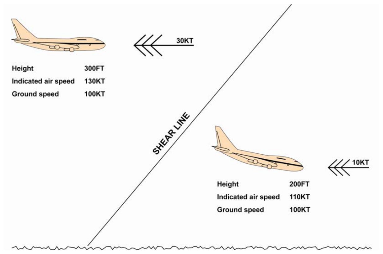
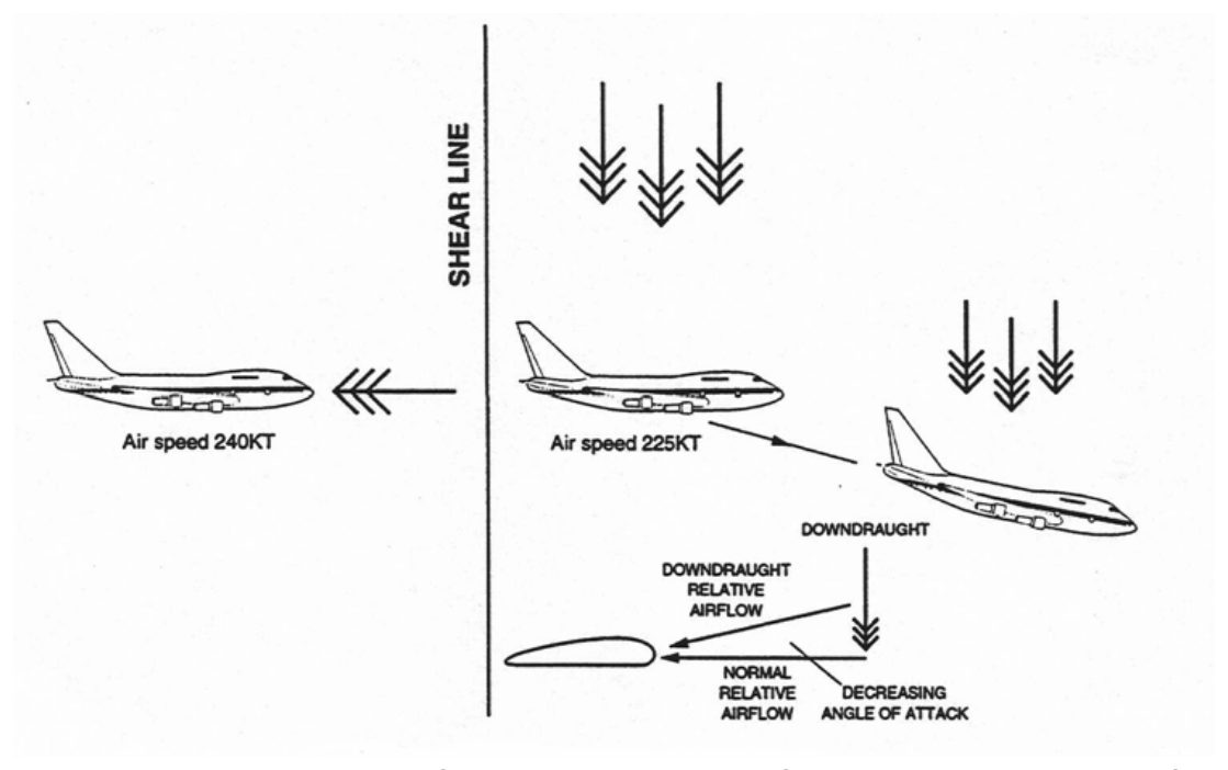
| Type of WS | Definition |
|---|---|
| Low Level WS | WS along final approach, runway, take-off path, and initial climb out flight path |
| Vertical WS | The change in horizontal wind vector with height |
| Horizontal WS | The change in horizontal wind vector with distance |
| Up-Downdraughts | Change in vertical component of wind vector with distance |
Causes of Wind Shear
1. Thunderstorm (TS)
(a) Gust Front (GF): The cold downdraught from TS spreads all around and creates GF as it meets the warm air near the ground. GF may extend as far as 30 km in the direction of storm movement and extend to about 6000 ft from ground. Great turbulence and WS are produced in the area, due to opposing winds and eddies.
(b) Microburst: Highly concentrated downdraught from TS, about 4 km across, lasting for 1-5 minutes. Most hazardous and powerful. Winds can be 90 kt and their directions may also be opposite at the surface.
| Microburst Type | Origin | Description |
|---|---|---|
| Wet Microburst | Heavy downpour under TS | Due to evaporation and cooling of cold downdraught |
| Dry Microburst | High based CB or Anvil (CI) in region of Virga | Virga = rain shaft evaporating before reaching ground |
2. Low Level Inversion
Develops in clear nights; may extend to about 1 km. In friction layer, winds are weak and winds aloft are strong → WS across inversion.
3. Gusty Surface Winds
Lead to strong gusts and lulls → WS.
4. Solar Heating
Intense solar heating causes WS and turbulence due to up and downdraughts.
5. Topography
Strong winds blowing across natural and man-made obstacles (mountain ranges, high rise buildings, flow along valleys, etc.) all lead to WS.
6. Fronts
Abrupt change of temperature and wind at a front. With passage of a front, strong WS may result; cross, head or tail wind. Very strong winds may also be encountered ahead of a Cold Front.
7. Jetstream
Strong vertical and horizontal WS are associated with jet streams in upper air.
Effects of WS on Aircraft
| Sudden shear encountered | Initial effect |
|---|---|
| Decreasing headwind or increasing tailwind | Airspeed and performance decrease. |
| Increasing headwind or decreasing tailwind | Airspeed and performance increase. |
Actual flight-path response depends on the aircraft, vertical wind and crew response. Follow approved aircraft windshear procedures.
flowchart TD
    WS["WIND SHEAR HAZARD"] --> A["Thunderstorm"]
    WS --> B["Low Level Inversion\n(Night)"]
    WS --> C["Fronts"]
    WS --> D["Topography"]
    WS --> E["Jetstream"]
    A --> A1["Gust Front\n(30km, 6000ft)"]
    A --> A2["Microburst\n(4km, 1-5min, 90kt)"]
    A2 --> A2a["Dry\n(Virga/Anvil)"]
    A2 --> A2b["Wet\n(Heavy Rain)"]
8. Local Winds Due to Topography
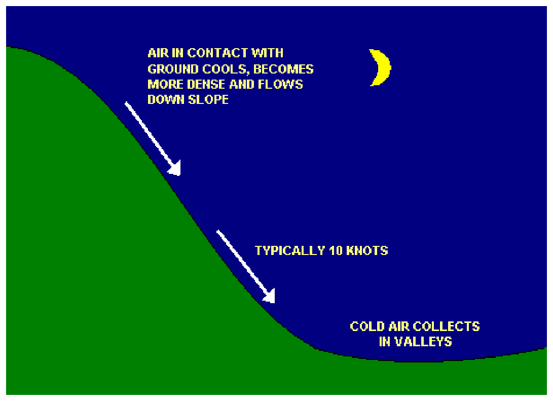
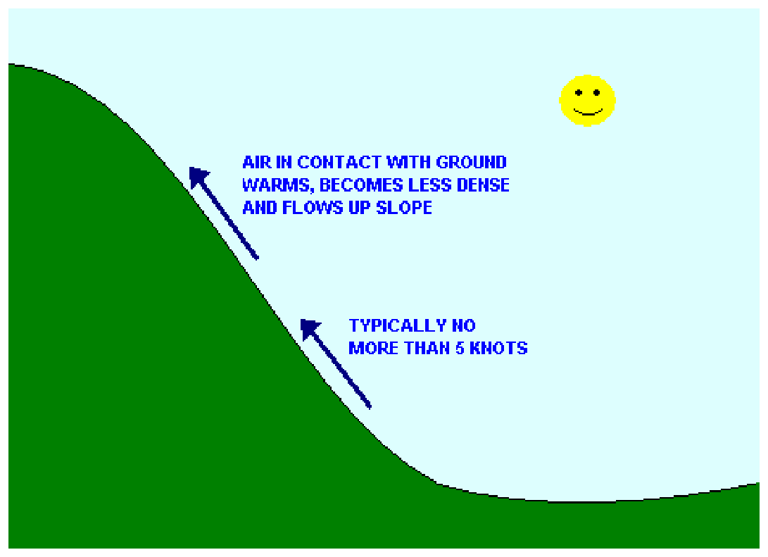
Anabatic and Katabatic Winds
| Feature | Anabatic (Valley) Wind | Katabatic Wind |
|---|---|---|
| Time | Daytime | Night (clear, quiet night) |
| Direction | Up-slope (mountain slope heated by sun) | Down-slope (mountain slope cools at night) |
| Character | Warm, lighter; ascends the slope; masked by irregular convection; intensified by sea breeze in funnel valley | Cold, down-slope wind; pools of cold on low-lying ground; causes local frost, mist and fog |
| Speed | Variable | No more than a few knots normally; Bora can exceed 100 kt |
| Aviation Hazard | Fog, TS in morning over NE India (when snow covered slopes) | Fog, frost; Bora (100+ kt) dangerous to shipping and low-flying aircraft |
Fohn Wind
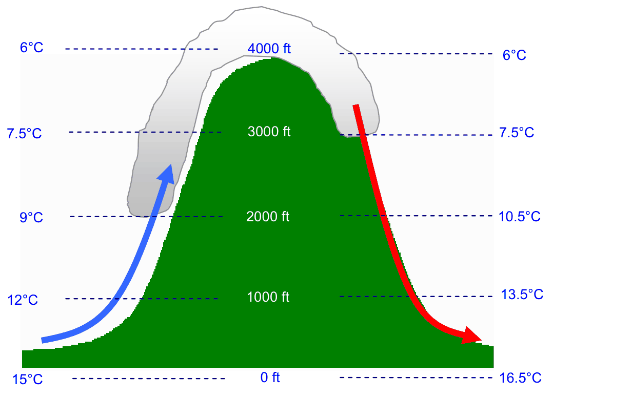
- In high mountains, Fohn wind may be 10°C or more warmer than windward side
- The Chinook of the Rocky Mountains is an example
- Conditions for Fohn: (a) substantial mountain range, (b) wind blows within 30° of range, (c) high moisture content
Ravine Winds
Occur in and near narrow valleys when there is a pressure difference between two sides of the hills. Air is impelled through the valley by the pressure gradient. Such winds may be very strong in the ravine and also after leaving its mouth.
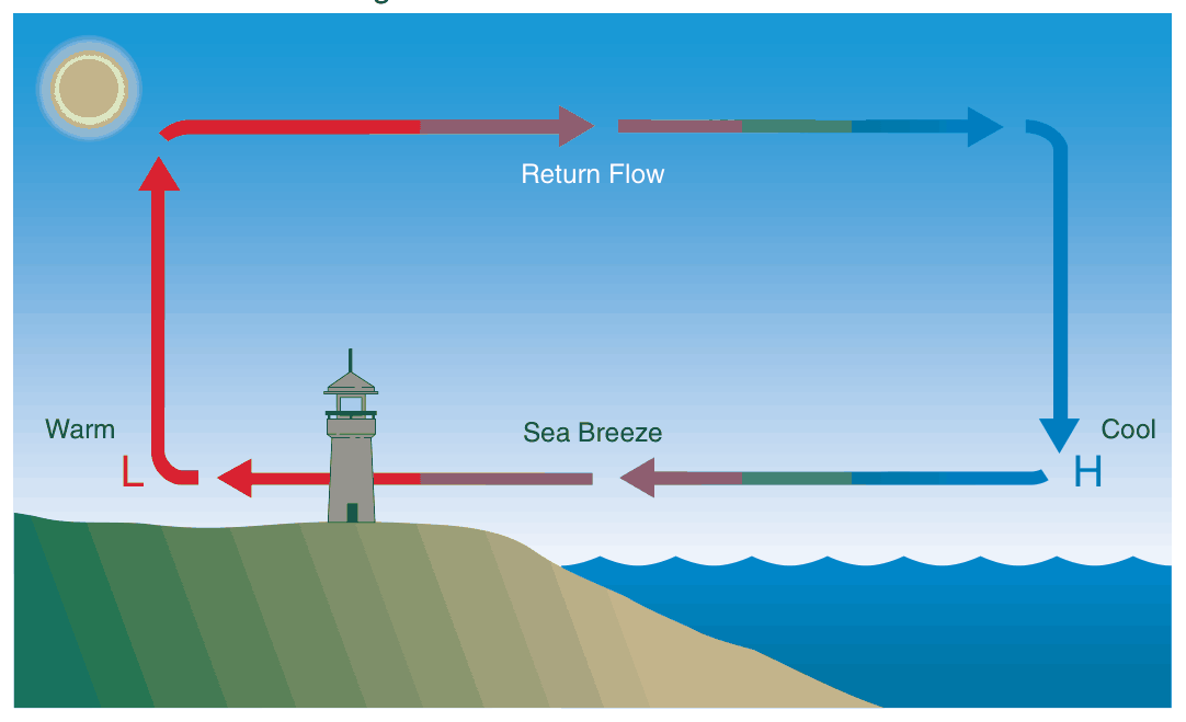
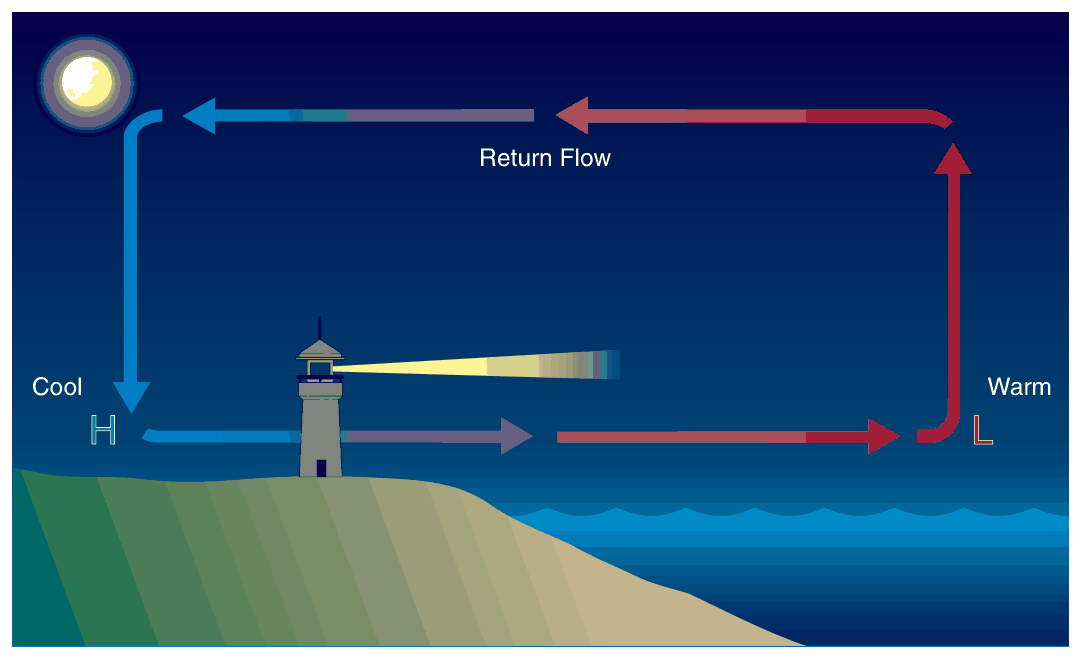
Land Breeze and Sea Breeze
| Feature | Sea Breeze | Land Breeze |
|---|---|---|
| Time | Day-time | Night |
| Direction | Sea → Land | Land → Sea |
| Cause | Land warmer → air rises → pressure aloft greater → upper air drifts to sea → sea level pressure over land drops → sea breeze | Radiative cooling of land → thermals die → friction layer shrinks → land breeze sets in |
| Extent | Generally 15-25 km on either side of coast; in Pune ~170 km from Mumbai | Shallower than sea breeze; few hundred feet only |
| Onset | Few hours after sunrise; delayed if off-shore wind | After sunset |
| Alignment | Initially perpendicular to coastline; then aligns with Coriolis (land on left in S hemisphere, right in N) | — |
| Other | In tropics and subtropics: routine and perpendicular to coast; may develop to 3000-5000 ft in tropics → line of small cumuliform clouds | Undetected by powered aircraft; useful to glider pilots |
9. Thermal Wind & Contours
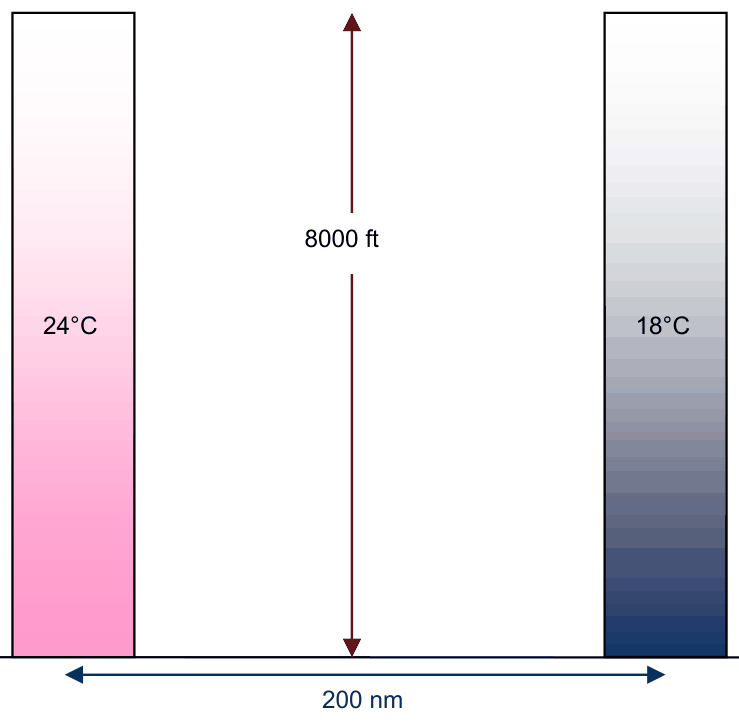
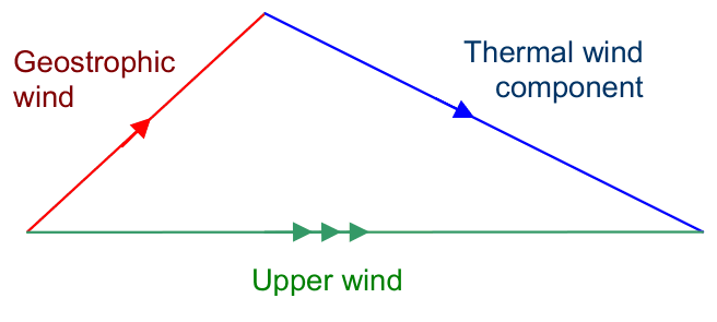
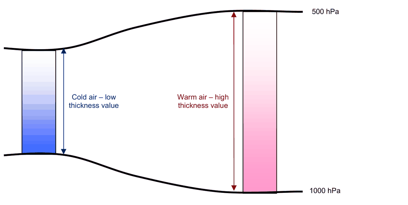
Thermal Wind
Vt = thermal wind, V1 = upper level geostrophic wind, V0 = lower level geostrophic wind
Vector addition: Draw one vector; from head draw the other; join tail of first to head of second = sum.
Vector subtraction: direction of second vector is reversed.
Example: Calculation of Upper Level Wind
| Lower Level Wind | Thermal Wind | Upper Level Wind |
|---|---|---|
| 270/10kt | 270/15kt | 270/10kt + 270/15kt = 270/25kt |
| 270/10kt | 090/15kt | 270/10kt + (−270/15kt) = 090/05kt |
- Thermal wind blows parallel to isotherms/thickness lines, keeping low temperature to the left in N hemisphere
- Speed is proportional to the temperature gradient
- If south is warm and north cold: temperature gradient acts S→N → thermal wind is Westerly
- If such temperature distribution continues, thermal wind will continue to be westerly from level to level → keeps increasing with height
- Subtropical westerly Jet Stream is an example of thermal wind
Wind and Contours
- Geostrophic wind blows along contours with lower value on the left in N hemisphere, right in S hemisphere
- Contour charts can determine cyclostrophic and gradient winds
- Limitations of geostrophic rule equally apply to contour charts
Variation of Wind with Height
- Temperatures in troposphere decrease from equator to poles → thermal wind component throughout troposphere blows from Wly (W)
- In the upper troposphere the winds are, therefore, mainly Wly
- Over India: easterlies prevail above 500 hPa during monsoon months (June, July, August, September); strengthen with height, weaker over N India and stronger over S India; tropical easterly jetstream lies near 13N lat at about 15 km
- Outside tropics: low level easterlies increase with height with little change in direction; on other hand easterlies weaken and become westerly
- Westerly thermal wind: northerly winds would back with height, southerly winds would veer
- In low stratosphere (winters): temperature lowest between 40° and 60° lat → westerlies increase with height; equatorwards of temperature maximum → westerlies decrease above tropopause
- Summer hemisphere: temperatures highest in polar regions → easterly thermal wind in stratosphere
10. Vorticity
Causes of Vorticity
- Horizontal Wind Shear: When a belt of strong winds lies alongside a belt of lighter winds, the faster flow rotates around the slower flow. May be cyclonic or anticyclonic depending on orientation.
- Curvature of the Flow: Flow around a curve has cyclonic vorticity when air deflects to its left (in trough, N hemisphere) and anticyclonic when it deflects to the right (ridge).
- Rotation of the Earth: Earth rotates from W to E (anti-clockwise = cyclonic for N hemisphere). Hence vorticity due to earth is cyclonic in both hemispheres.
11. Names of Winds of the World
| Wind Name | Character | Location |
|---|---|---|
| Bora | Cold katabatic; originates in mountains of Yugoslavia and NE Italy | Coastal plains of the Adriatic sea |
| Burans (Russian Burans / Turkish Boran) | Strong NEly wind in Russia and Central Asia; often blows snow ('Purga') | Russia and Central Asia |
| Chinook | Warm dry Wly wind | Eastern side of Rocky Mountains |
| Doldrums | Calm winds near Equator; low atmospheric pressure; insignificant wind; cloudy and rainy; also called ITCZ | Between ~5°N and 5°S lat |
| Haboobs (Arabic: blowing furiously) | Any strong wind raising sand into a sand storm | Particularly in Sudan |
| Harmattan | Hot dusty NEly | Central Asia |
| Khamsin | Oppressive, hot, dry, often laden with sand; Sly wind | Egypt, April–June |
| Mistral | Cold katabatic — descends from snow-clad Alps down the Rhone River Valley | France and into Gulf of Lyons along the Mediterranean coast |
| Monsoon | Any markedly seasonal wind | Particularly E and SE Asia |
| Roaring Forties | Wly winds in both hemispheres between 35° and 60° lat; very stormy nature beyond 40° lat in S hemisphere. Called Roaring Forties, Furious Fifties, Crying Sixties | Mid-latitudes S hemisphere |
| Trades | Steady wind between 10° and 30° from NE in N hemisphere, SE in S hemisphere; 'wind that blows trade' by 18th century navigators | Subtropics both hemispheres |
12. Beaufort Force Scale
| BF Scale | Description | Speed at 10m (kt) |
|---|---|---|
| 0 | Calm | <1 |
| 1 | Light air | 1–3 |
| 2 | Light breeze | 4–6 |
| 3 | Gentle breeze | 7–10 |
| 4 | Moderate breeze | 11–16 |
| 5 | Fresh breeze | 17–21 |
| 6 | Strong breeze | 22–27 |
| 7 | Near Gale | 28–33 |
| 8 | Gale | 34–40 |
| 9 | Strong Gale | 41–47 |
| 10 | Storm | 48–55 |
| 11 | Violent Storm | 56–63 |
| 12 | Hurricane | 64 or more |
Practice Q&A — Chapter 6: Winds
(a) Right (b) Left
(a) Left (b) Right
(a) False (b) True
(a) Left (b) Right
(a) Coriolis and Frictional
(b) Pressure gradient and Cyclostrophic
(c) Pressure gradient and Coriolis
❌ (b) PGF + Cyclostrophic: Cyclostrophic balance is P = Centripetal (curved isobars near equator).
(a) Mid latitudes (b) Poles (c) Equator
❌ (c) Equator: sin 0° = 0, so Coriolis = zero at equator.
(a) Mid latitudes (b) Poles (c) Equator
❌ (b) Poles: Geostrophic rule gives a good approximation beyond 30°; also breaks at poles due to pressure changes with time but rule is NOT primarily said to break down here.
(a) Dry (b) Cold & Humid
(a) Fohn (b) Anabatic (c) Katabatic
❌ (b) Anabatic: Anabatic is daytime up-slope wind.
(a) Fall/Rise (b) Rise/Fall (c) Fall/Fall
❌ (c) Fall/Fall: RH rises as maritime air is more humid.
(a) Night/Day (b) Day/Night (c) Both Day and Night
❌ (c) Both Day and Night: Sea breeze is specifically a daytime phenomenon.
(a) Starboard drift (b) Port drift
(a) Under (b) Over
(a) Isobars (b) Isotachs (c) Isogons
❌ (c) Isogons: Lines of equal wind direction.
(a) Shorter duration (b) Longer duration (c) Lower wind speed
❌ (c) Lower wind speed: Squalls actually have higher wind speeds (must reach 44 km/h) and are more dangerous.
(a) The wind that blows because of thermals
(b) The warm wind that blows down the hill on the leeward side
(c) The wind which must be added vectorially to the lower level geostrophic wind to obtain the upper level geostrophic wind
❌ (b) Warm wind on leeward: That is the Fohn wind.
(a) Light and parallel to isobars
(b) Strong and parallel to isobars
(c) Strong and blowing across the isobars
(a) At night (b) Any time of day and night (c) During day
❌ (b) Any time: Anabatic is specifically a daytime phenomenon.
(a) True (b) False
(a) True (b) False
(a) True (b) False
(a) True (b) False
(a) True (b) False
(a) True (b) False
(a) True (b) False
(a) True (b) False
(a) Gradient wind (b) Geostrophic wind (c) Cyclostrophic wind
❌ (c) Cyclostrophic: Only PGF + Centripetal (Coriolis negligible).
(a) True (b) False
(a) Turbulence (b) High pressure area (c) Low pressure area
(a) 05005kt (b) 23015kt (c) 05015kt
(a) Backing (b) Veering
(a) Backing (b) Veering
(a) Gust (b) Squall (c) Gale
(a) Gust (b) Squall (c) Gale
(a) False (b) True
(a) True (b) False
(a) False (b) True
(a) 20°/10° (b) 30°/15° (c) 40°/30°
(a) Ely (b) Wly (c) Sly (d) Nly
(a) Persistent strong winds with mean speed 44kt, associated with thunderstorms
(b) Marked increase in wind speed lasting few minutes associated with CB or DS
(c) Persistent strong winds exceeding 33kt, associated with depression
❌ (b) Lasts few minutes with CB: That is the description of squall.
(a) Isobars (b) Isotherms (c) Isallobars
❌ (c) Isallobars: Related to pressure change, relevant to Isallobaric wind.
(a) cyclonic in both the Hemispheres
(b) anti cyclonic in both the Hemispheres
(c) anti cyclonic around an anticyclone
(a) 16010kt (b) 24040kt (c) 24010kt
Master Reference Tables — Chapter 6: Winds
Key Numerical Values
| Parameter | Value |
|---|---|
| Anemometer height | 10 m |
| Wind average for all observations | 10 minutes |
| Wind average for T/O & landing | 2 minutes |
| Squall: minimum wind increase | 32 km/h (16 kt, 08 mps) |
| Squall: minimum speed reached | 44 km/h (22 kt, 11 mps) |
| Squall: minimum duration | 1 minute |
| Gale: minimum speed | 34 kt |
| Friction layer height | ~1 km |
| Surface wind angle over sea | 15° |
| Surface wind speed over sea | 2/3 Vg |
| Surface wind angle over land | 30° |
| Surface wind speed over land | 1/3 to 1/2 Vg |
| Night wind shear height | ~500 m |
| Gust Front extent | 30 km horizontally, 6000 ft height |
| Microburst diameter | ~4 km |
| Microburst duration | 1–5 minutes |
| Microburst wind speed | up to 90 kt |
| Sea breeze extent along coast | 15–25 km either side |
| Sea breeze inland extent (Pune case) | ~170 km from Mumbai |
| Bora gusts | over 100 kt |
| Fohn warmth advantage over windward | 10°C or more in high mountains |
| Tropical easterly jetstream latitude | 13N, at ~15 km |
| Monsoon easterlies above | 500 hPa (Jun–Sep) |
| Roaring Forties latitude range | 35°–60° |
| Trade winds latitude range | 10°–30° |
| Doldrums latitude | 5°N–5°S |
| BF 8 (Gale) | 34–40 kt |
| BF 12 (Hurricane) | ≥64 kt |
Formula Sheet
| Formula | Explanation |
|---|---|
| f = 2ΩρV sinφ | Coriolis Force; max at poles (φ=90°), zero at equator (φ=0°) |
| Vg = P/(2Ωρ sinφ) | Geostrophic wind; inversely proportional to sin φ and isobar spacing |
| ρV²/r = P → V = (Pr/ρ)^½ | Cyclostrophic wind; pressure-gradient and curvature balance |
| Vt = V1 − V0 | Thermal wind = upper level minus lower level geostrophic wind (vector) |
| Vi = fR | Inertial wind; f = Coriolis, R = radius of path; anticyclonic both hemispheres |
Wind Type Comparison
| Wind | Forces | Isobar Shape | Friction | Where |
|---|---|---|---|---|
| Geostrophic | P + f | Straight, parallel | No | Mid-latitudes, free atmosphere |
| Cyclostrophic | P + Centripetal | Curved | No | Near equator, tornadoes |
| Gradient | P + f + C | Curved | No | Mid-latitudes, upper air |
| Isallobaric | P + f + Isallobaric | Any | No | Rapid pressure change areas |
| Inertial | f + Centrifugal | No PGF | No | Any; anticyclonic both hemi |
| Surface wind | P + f + F | Any | Yes | Friction layer (surface–1km) |
Quick Revision Summary
Measurement: Anemometer (speed) + Wind Vane (direction) at 10m; 10-min average (2-min for T/O/Landing)
Squall: +32 kmh → 44 kmh, ≥1 min, CB associated. Gust = seconds. Gale = ≥34kt mean persistent
Backing = ACW; Veering = CW. Buys Ballot: Back to wind → Low on Left (N hemi)
Coriolis: f = 2ΩρV sinφ; max poles, zero equator; right in N hemi, left in S hemi
Winds: Geo = P↔f (straight). Cyclo = P↔C (curved, equatorial). Gradient = P+f+C. Inertial = f+C (anticyclonic both hemi)
Friction: Layer ~1km. Sea: 15°, 2/3Vg. Land: 30°, 1/3–1/2 Vg. Night WS at ~500m = aviation hazard
WS: TS Gust Front (30km, 6000ft); Microburst (4km, 1-5min, 90kt; dry = Virga; wet = downpour)
Local winds: Ana = up/day; Kata = down/night (Bora >100kt). Fohn = warm dry leeward. Sea Breeze = day; Land Breeze = night
Thermal Wind: Vt = V1-V0; parallel to isotherms; low temp LEFT (N hemi); subtropical jet example
Beaufort: 8=Gale(34-40kt); 12=Hurricane(≥64kt)
Reinforce Chapter 6: Winds
Test your knowledge and practice actual exam questions for Aviation Meteorology.