Earth Magnetism
by Ghost Aviator
Contents
- 1. True, Magnetic & Compass Direction
- 2. Variation — Definition & Observer Geometry
- 3. Situation at the Poles — Maximum Variation
- 4. The Real Variation Map — Isogonals & Agonic Lines
- 5. Changes in Variation Over Time
- 6. Updating Isogonals on Charts
- 7. Magnetic Dip — Angle, H and Z Components
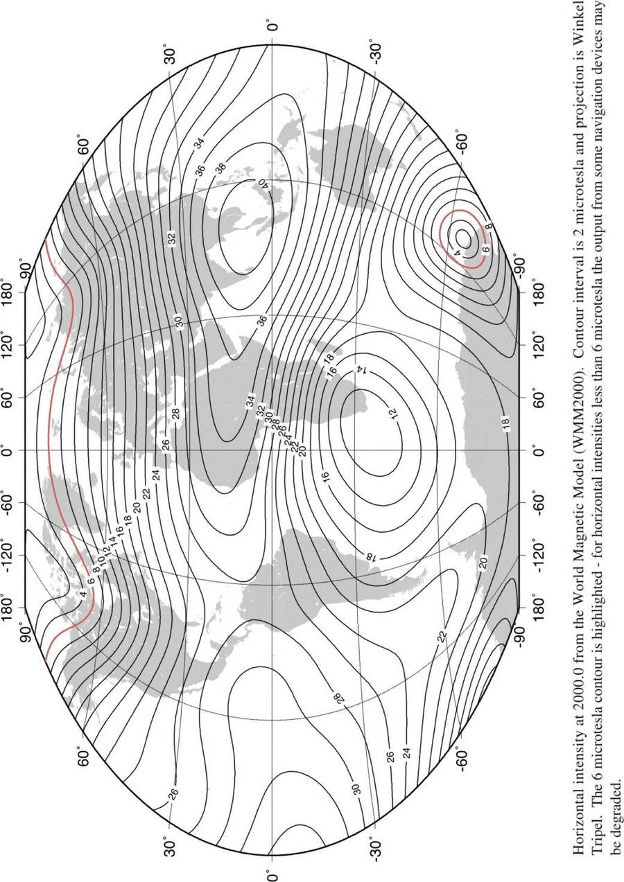
- 8. The 6 µT Threshold & Compass Reliability
- 9. Deviation — Definition & Sign Convention
- 10. Applying Variation & Deviation — CADIZ Rules
- 11. All Definitions
- Practice Questions & Detailed Answers
- Master Reference Tables
1. True, Magnetic & Compass Direction
🔎 Three Reference Datums for Direction
| Datum | Reference | Suffix | Source |
|---|---|---|---|
| True | Geographic (True) North Pole | (T) | Maps, INS |
| Magnetic | Magnetic North Pole | (M) | Magnetic compass (after deviation correction) |
| Compass | Compass North (aircraft compass) | (C) | Aircraft compass (affected by aircraft magnetism) |
True direction is what is shown on maps — the direction to the geographic North Pole. An INS (Inertial Navigation System) finds True direction by detecting Earth's rotation. Most aircraft, however, use magnetic compasses as primary heading references, with INS as a standby or supplement.
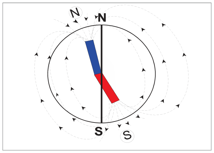
The Earth behaves as though a huge, slightly bent bar magnet runs through it, with its magnetic poles approximately (but not exactly) aligned with the True poles. This misalignment creates the need to convert between True, Magnetic, and Compass headings in flight planning.
2. Variation — Definition & Observer Geometry
🔎 Definition
Variation is the angular difference between the directions of True North and Magnetic North at any point. Measured in degrees East or West from True North. Suffix: E or W.
- A line joining points of equal variation is an Isogonal (shown as a pecked/dashed line on charts).
- The isogonal of zero variation is the Agonic Line.
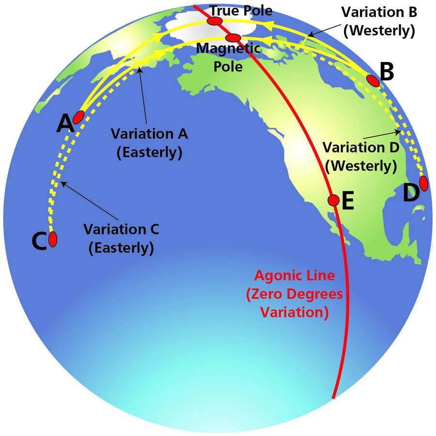
How Observer Position Determines Variation
The variation at any point depends on the geometry of the observer, the True North Pole, and the Magnetic North Pole:
- Observer A: Magnetic North Pole is to the right of True North → Easterly variation
- Observer B: Magnetic North Pole is to the left of True North → Westerly variation
- Observer C/D: Further from both poles → smaller angle of variation
- Observer E: On the Great Circle joining True and Magnetic Poles → zero variation (on the Agonic Line)
3. Situation at the Poles — Maximum Variation
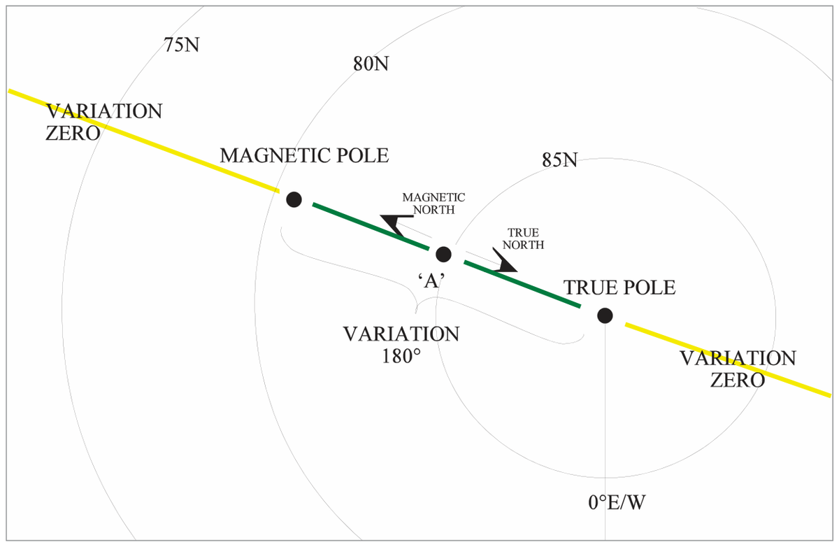
For an observer on the arc of the Great Circle between the True North Pole and the Magnetic North Pole:
- True North points one way (toward the True Pole)
- The compass needle points in exactly the opposite direction (toward the Magnetic Pole)
- The variation at such a point is exactly 180°
⚠ Maximum Variation = 180°
The maximum possible value of variation is 180°. It occurs between the True and Magnetic Poles. At the True Poles themselves, isogonals converge and variation is indeterminate (all directions are either only North or only South).
4. The Real Variation Map — Isogonals & Agonic Lines
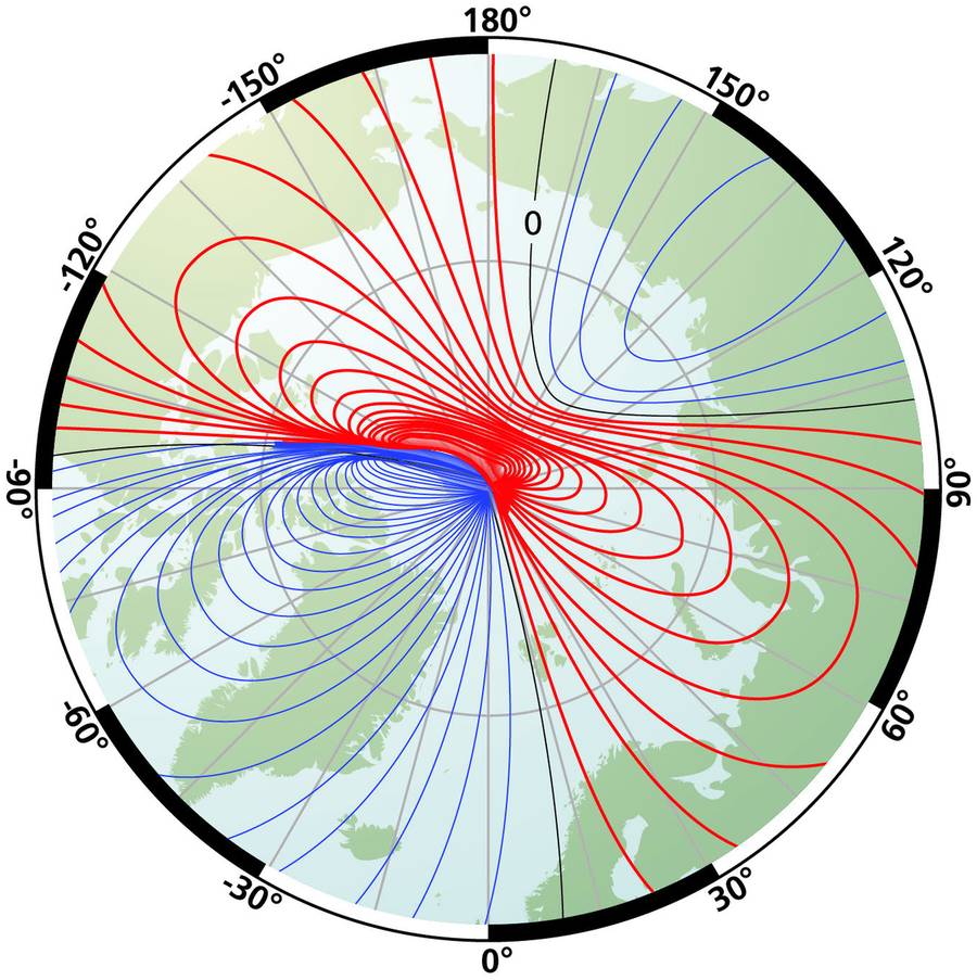
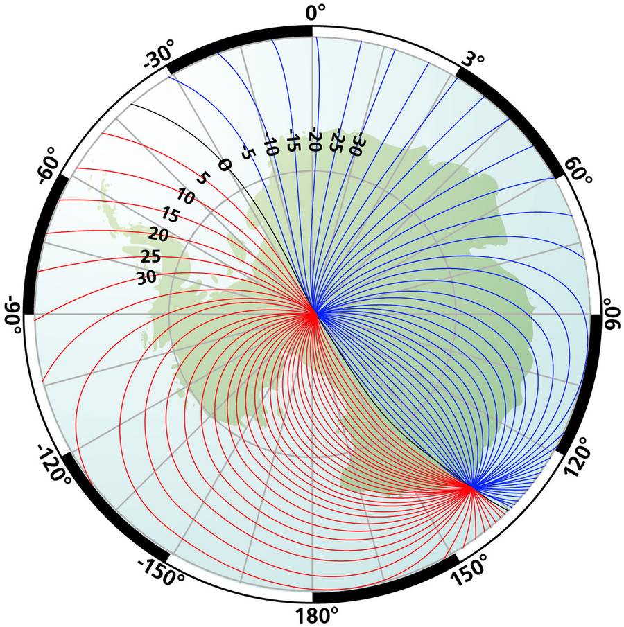
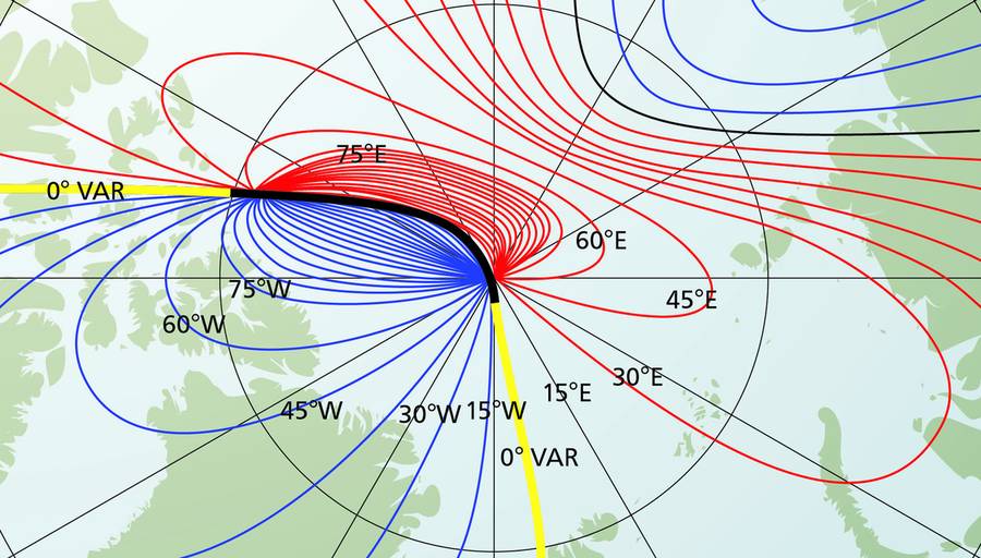
The real magnetic field is more complex than the idealised model — it resembles a bent bar magnet. The North Magnetic Pole (NERC 2000 survey) was at approximately 81°N 110°W; the South Magnetic Pole at approximately 63°S 135°E — they are not antipodal.
There are two Agonic Lines (zero-variation lines), both starting from the True North Pole:
- One runs southward through Western Europe → Stuttgart, Germany → Central Africa → back via North-Central Asia → Australia → South Magnetic Pole
- The other runs southward through the USA → South America → True South Pole
⚠ Key Exam Facts — Isogonals
- Isogonals converge on all four poles — both True (Geographic) AND both Magnetic poles
- Isogonals are NOT the same as magnetic field lines — they show the difference between local field direction and True North
- Zero variation (Stuttgart area) does NOT mean no magnetic field — it means Magnetic North = True North at that point
5. Changes in Variation Over Time
Variation at any point changes with time because the Magnetic Poles are moving. There are several overlapping cycles:
| Type | Period | Cause | Magnitude |
|---|---|---|---|
| Secular | Long-term drift | Movement of molten magma in the Earth's core; Magnetic Pole moving westward & northward | ~1°/9 years at some locations |
| Annual | ~1 year | Earth's orbit round the Sun (sinusoidal) | Small |
| Diurnal | ~1 day | Daily changes in ionosphere height as Earth rotates | Up to ~0.1° |
| Solar activity | 11-year sunspot cycle (unpredictable) | Solar flares hitting the ionosphere — "magnetic storms" | Up to 7° observed |
| Local anomalies | Constant | Magnetic rock deposits or formations below surface | Variable |
📚 Practical Accuracy
It is very difficult to know the instantaneous variation to better than about ±2°. Over a period of time with careful correction, accuracy of ±0.5° is achievable. This is why INS (accurate heading from gyros) was a major advance in the 1960s–70s.
6. Updating Isogonals on Charts
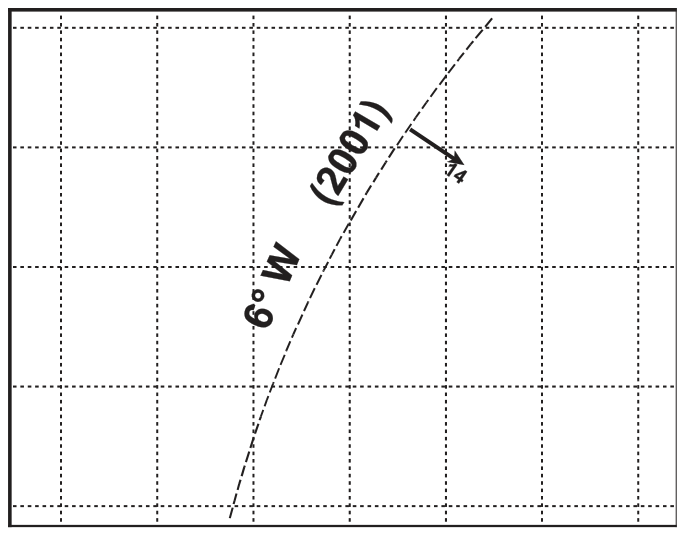
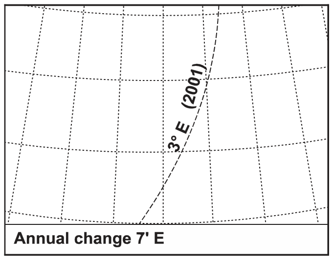
For frequently republished radio-navigation charts, isogonals are usually current enough. For topographical maps republished every 5–10 years, pilots may need to update isogonals during flight planning. Charts show the year of origin and the annual change in one of two ways:
7. Magnetic Dip — Angle, H and Z Components
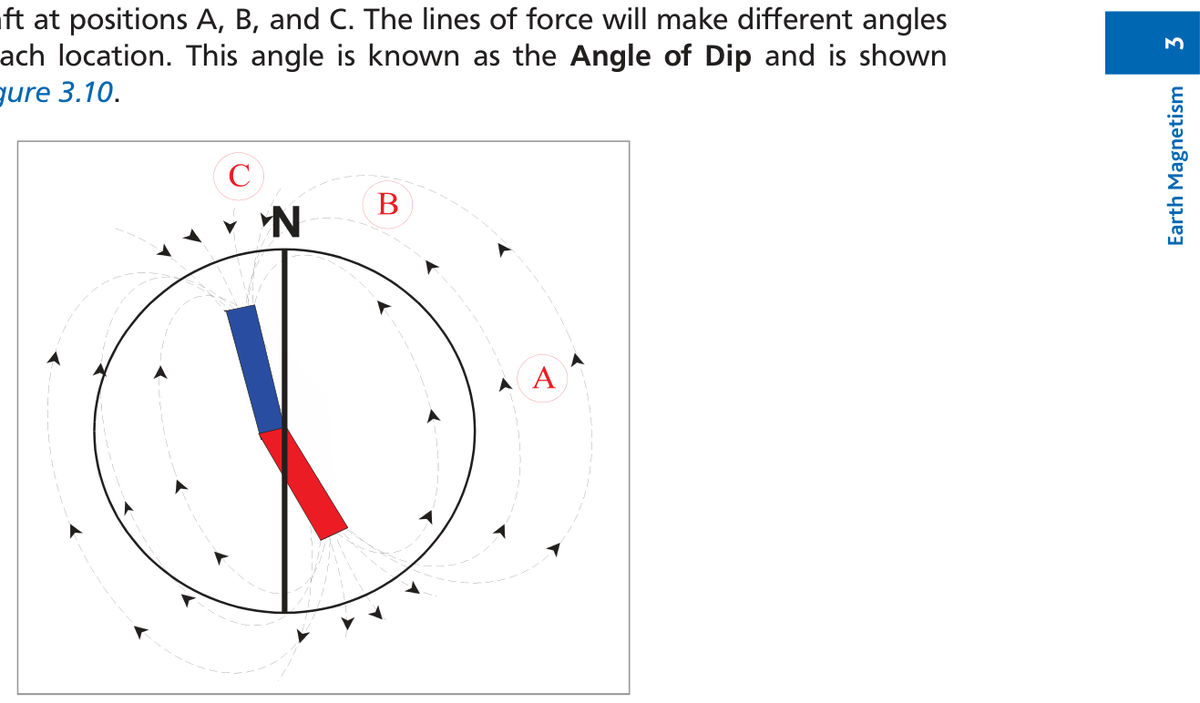
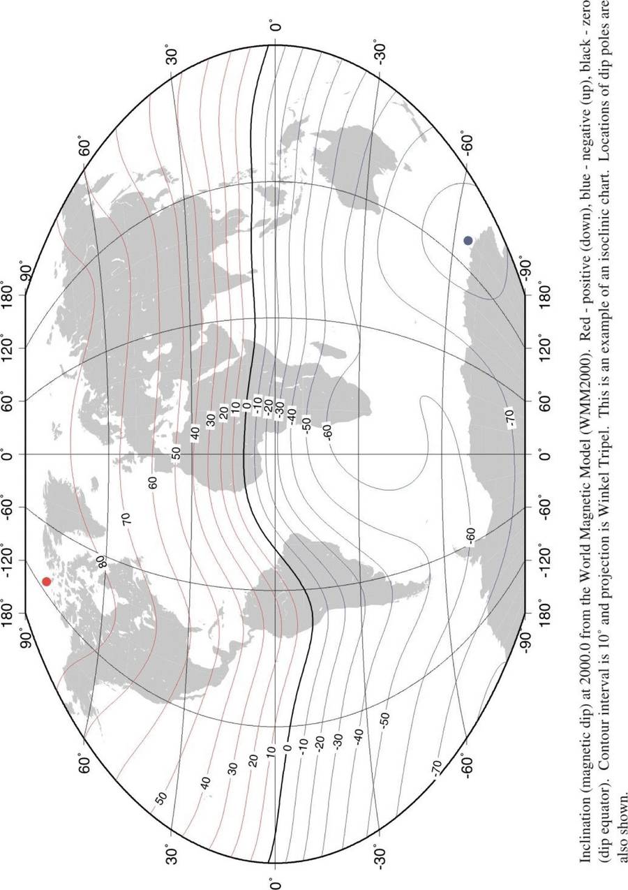
The Earth's magnetic field acts along a total force vector T, which is directed into the Earth at an angle to the horizontal. This angle is the Angle of Dip.
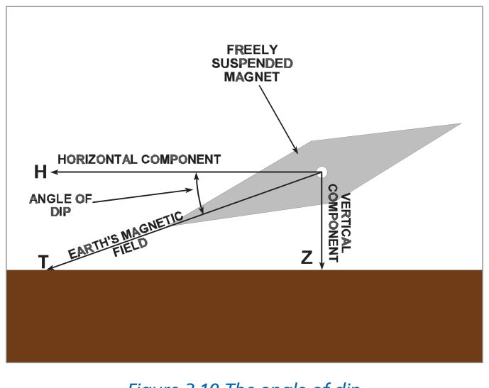
Resolving T into H and Z
| Component | Symbol | Direction | Compass use |
|---|---|---|---|
| Total force | T | Along field line (into Earth at dip angle) | — |
| Horizontal component | H | Horizontal — toward Magnetic North | USEFUL — the directive force |
| Vertical component | Z | Vertical — into the Earth | USELESS — causes dip errors |
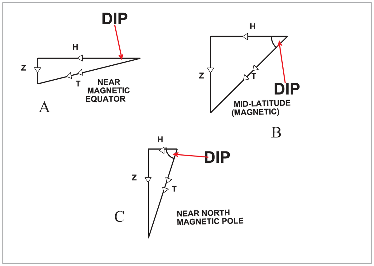
Relationship Between Dip and H
- At the magnetic equator: Dip = 0°, H ≈ T (maximum — compass most effective)
- As latitude increases toward the poles: Dip increases, H decreases, Z increases
- At the magnetic poles: Dip = 90°, H ≈ 0 (compass unreliable)
- At a typical mid-latitude UK location: Dip ≈ 66°
⚠ Two Problems Caused by Z (Vertical Component)
1. Compass dip: Z causes the compass needle to hang down from the horizontal, creating turning and acceleration errors (partially corrected by pendulous suspension — residual ~2° at a typical mid-latitude location).
2. Soft-iron deviation increase: Z induces vertical soft-iron magnetism in the aircraft structure, adding to deviation.
Magnetic field strength is measured in microteslas (µT). H is the directive force. A line joining points of equal magnetic dip is an Isoclinal. The isoclinal of zero dip is the Aclinic Line (the magnetic equator).
8. The 6 µT Threshold & Compass Reliability
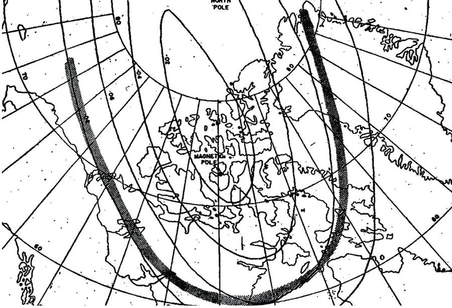
The accepted threshold below which H is too weak to reliably drive a magnetic compass is 6 microteslas (µT). Inside the 6 µT zone, compass reliability cannot be guaranteed.
📚 Exam Tip
The 6 µT zone exists around BOTH the North AND South Magnetic Poles. The 6 µT threshold is the notional figure — actual threshold depends on compass design. Maximum dip = 90° directly over either magnetic pole.
9. Deviation — Definition & Sign Convention
🔎 Definition
Deviation is the angle measured at a point between the direction indicated by a compass needle and the direction of Magnetic North. Termed East or West according to whether Compass North lies to the East or West of Magnetic North.
The aircraft itself contains magnetic influences (metal structures, electrical currents, equipment) which deflect the compass needle from its ideal alignment with Magnetic North. The compass then points to Compass North — not Magnetic North.
Sign Convention (±)
| Convention | East deviation | West deviation |
|---|---|---|
| Directional suffix | E (e.g. 3°E) | W (e.g. 3°W) |
| Algebraic sign | + (positive) | − (negative) |
Applied to Compass heading to give Magnetic heading: Hdg(M) = Hdg(C) + Deviation (using algebraic sign).
Equivalently: From Compass to Magnetic, the signs are true — East is +, West is −.
10. Applying Variation & Deviation — CADIZ Rules
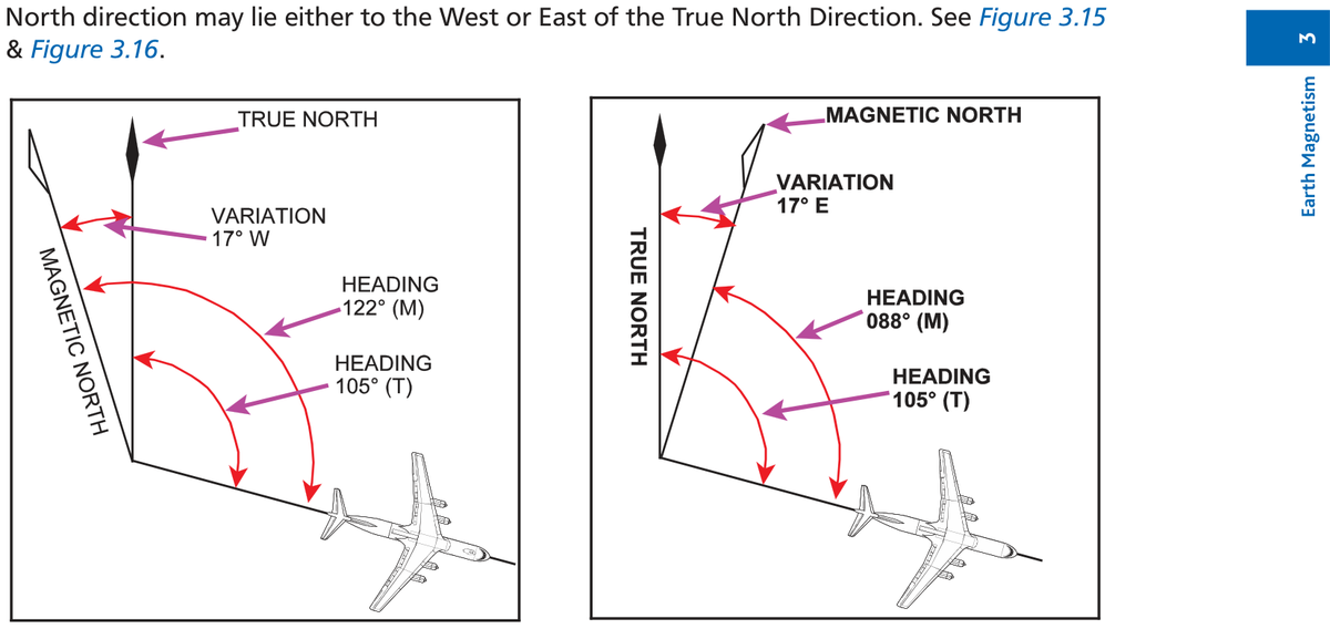

The CADIZ Chain: C → D → M → V → T
Apply deviation to Compass → get Magnetic; apply variation to Magnetic → get True
Worked Examples — Variation
| Heading True | Variation | Heading Magnetic | Rule |
|---|---|---|---|
| 105°(T) | 17°W | 122°(M) | West → M best (add) |
| 105°(T) | 17°E | 088°(M) | East → M least (subtract) |
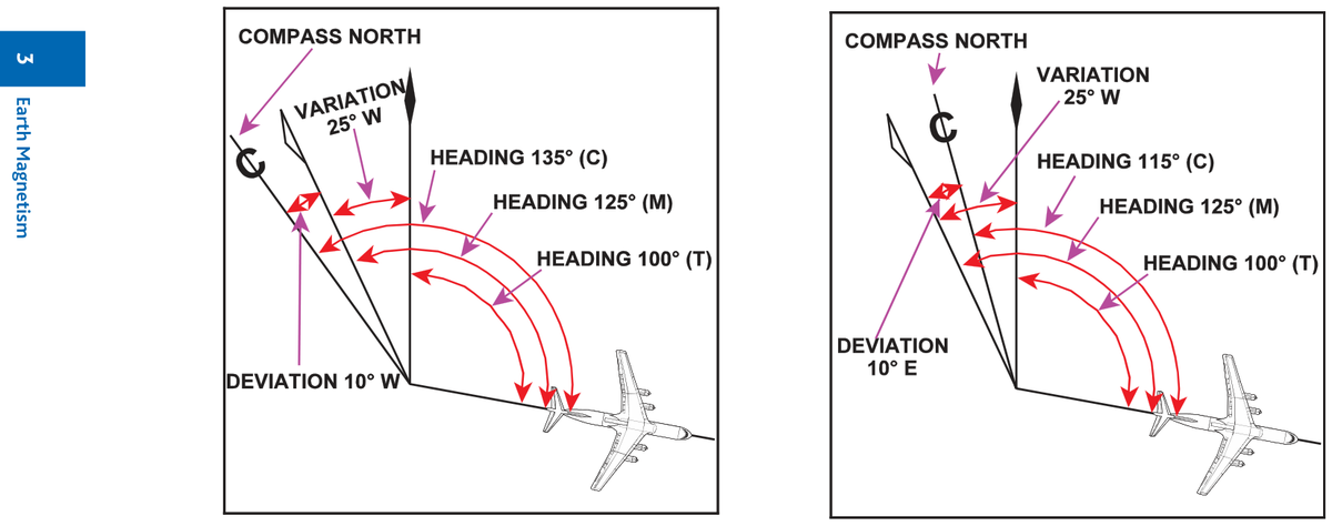
Worked Examples — Deviation
| Heading Magnetic | Deviation | Heading Compass | Rule |
|---|---|---|---|
| 125°(M) | 10°W | 135°(C) | West → C best (add) |
| 125°(M) | 10°E | 115°(C) | East → C least (subtract) |
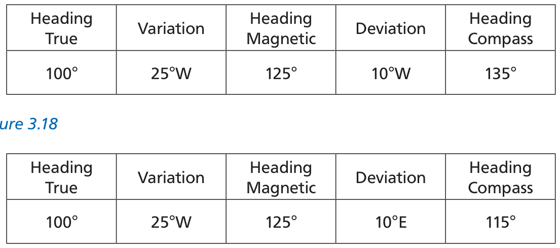
Full T → M → C Example
| °True | Variation | °Magnetic | Deviation | °Compass |
|---|---|---|---|---|
| 100°(T) | 25°W | 125°(M) | 10°W | 135°(C) |
| 100°(T) | 25°W | 125°(M) | 10°E | 115°(C) |
✎ ± Notation Example
Deviation 3°E = +3. Heading(M) = 263°. Find Heading(C):
"Deviation East → Compass Least" → C = M − 3 = 260°(C)
Check: C + deviation = M → 260 + (+3) = 263 ✓
11. All Definitions
| Term | Definition |
|---|---|
| Heading | Direction of the fore-and-aft axis of the aircraft. May be measured from True, Magnetic, or Compass North. |
| Variation | Angle between True North and Magnetic North at a point. East if MN is East of TN; West if MN is West of TN. |
| Deviation | Angle between Magnetic North and the direction indicated by the compass. East if Compass North is East of MN; West if West. |
| Isogonal | Pecked line on a chart joining places of equal magnetic variation. |
| Agonic Line | Isogonal joining places of zero variation. |
| Angle of Dip | Angle in the vertical plane between the horizontal and the Earth's total magnetic force at a point. |
| Isoclinal | Line on a chart joining places of equal magnetic dip. |
| Aclinic Line | Isoclinal joining places of zero dip (the magnetic equator). |
📚 Note on Isoclinals / Aclinic Lines
Isoclinals and Aclinic Lines do NOT appear on standard navigation charts. They appear only in specialist geomagnetic publications.
📚 Quick Revision — Chapter 3
- Three North datums: True, Magnetic, Compass
- Variation = True North to Magnetic North; Deviation = Magnetic North to Compass North
- CADIZ: Var West = Mag Best; Var East = Mag Least; Dev West = Comp Best; Dev East = Comp Least
- Max variation = 180° (between True and Magnetic poles)
- Isogonals converge on all four poles (True N, True S, Mag N, Mag S)
- Dip = 0° at magnetic equator; Dip = 90° at magnetic poles
- Compass most effective where H is maximum — midway between magnetic poles (magnetic equator)
- 6 µT = compass reliability threshold (H too weak below this)
- Variation changes: Secular (long-term), Annual, Diurnal (0.1°/day), Solar (up to 7°), Local anomalies
- Deviation sign: + = East, − = West; C + D = M (algebraic)
Practice Questions & Detailed Answers
14 MCQ + 1 TVMD table question • Full explanations & distractor analysis
▶ Show answer & explanation
The compass needle is driven by the horizontal component H. The larger H is, the greater the directive force and the more reliably the needle aligns with Magnetic North. Sensitivity is therefore proportional to H — more H means a more sensitive, reliable compass.
(a) Inverse of H would mean the compass works better near the poles — the opposite of reality.
(c/d) Z is the vertical component — it is unhelpful (causes dip errors) but sensitivity is not inversely proportional to it.
▶ Show answer & explanation
Variation is defined as the angular difference between True North and Magnetic North at a given point. More precisely, it is measured from True North to Magnetic North and termed East or West accordingly.
(a) Describes Deviation, not Variation.
(b) The angle between TN and Compass North is the combined effect of Variation + Deviation.
(d) Magnetic Heading relative to Magnetic North would simply be the heading itself — not meaningful.
▶ Show answer & explanation
The magnetic equator (Aclinic Line) is defined as the line of zero dip. At the magnetic equator, the total field T is horizontal — Z = 0 and H = T (maximum). Compass reliability is highest here.
(b) Variation is zero only on the Agonic Line, which does not follow the magnetic equator.
(c) Deviation depends on the aircraft's own magnetic properties — unrelated to magnetic equator.
(d) The isogonal at the magnetic equator is not an Agonic Line (except where the magnetic equator and Agonic Line happen to intersect).
▶ Show answer & explanation
In conventional magnetic labelling, a blue pole is a South-seeking pole (the end a compass South needle would point to). The Earth's geographic north region acts as a magnetic south pole — attracting the north-seeking (red) end of a compass needle. So 'blue magnetic pole in Northern Canada' correctly describes the Earth's field configuration near the Magnetic North Pole.
(b) Wrong — dip angle is between the horizontal and the total force T, not the vertical.
(c) Describes aircraft deviation categories, not the Earth's field.
(d) Wrong — the Earth's field induces magnetism in the aircraft, directly causing deviation.
▶ Show answer & explanation
The compass is most effective where H (horizontal component) is greatest. H is maximum at the magnetic equator, which lies approximately midway between the North and South Magnetic Poles. There H ≈ T and Z ≈ 0.
(b/c) At either magnetic pole, dip = 90°, H ≈ 0 — compass is least effective.
(d) Geographic equator ≠ magnetic equator. The geographic equator passes through regions of varying dip.
▶ Show answer & explanation
The maximum possible variation is 180°. This occurs at points between the True and Magnetic Poles where TN and MN point in exactly opposite directions. The Agonic Line (zero variation) is unrelated to the magnetic equator.
(a) Zero variation occurs on the Agonic Line — not on the magnetic equator.
(c/d) Both wrong — variation can theoretically reach 180°.
▶ Show answer & explanation
The text describes two Agonic Lines from the North pole region: one running through Western Europe (Stuttgart, Germany) and the other through the USA. Both pass through the poles. This is due to the complex, non-ideal shape of the Earth's magnetic field ('bent bar magnet' analogy).
(a) Midway between the magnetic poles would be the magnetic equator — the Aclinic Line, not the Agonic Line.
(b) The geographic equator has nothing to do with zero variation.
(c) The 180° variation line (not the Agonic Line = 0°) runs between True and Magnetic poles.
▶ Show answer & explanation
Variation is precisely the angle between True North and Magnetic North. Deviation is between Magnetic North and Compass North. Dip is the angle between horizontal and the total magnetic force.
(a) Deviation = MN to Compass North.
(c) Not a standard term in navigation.
(d) Dip = angle of field from horizontal.
▶ Show answer & explanation
The secular movement of the Magnetic Poles changes the relative geometry between observer, True Pole, and Magnetic Pole. Depending on the direction of pole movement and the observer's location, variation can either increase or decrease — it is not universally one or the other.
(a) Says movement always causes an increase — wrong, it depends on location.
(b/c) The total field strength is not the mechanism for changing chart variation.
▶ Show answer & explanation
Isogonals converge at all four poles — both True (Geographical) poles AND both Magnetic poles. This is because near any pole, all isogonals must converge as the pole is a singular point for direction. The text states explicitly: 'Isogonals converge on both the True and the Magnetic North and South Poles.'
(a) Only the North Magnetic Pole — incomplete.
(c) Both Magnetic Poles but not the Geographical Poles — incomplete.
(d) The magnetic equator is where isoclinals converge (zero dip), not isogonals.
▶ Show answer & explanation
Maximum dip = 90°, occurring directly over either Magnetic Pole where Z = T and H = 0. The field lines enter the Earth vertically.
(a) 66° is a typical dip angle at mid-latitude UK — a specific local value, not the maximum.
(b) 180° is the maximum possible variation, not dip.
(d) 45° has no physical significance here.
▶ Show answer & explanation
At either magnetic pole (North or South), the field lines are vertical — dip = 90°. The horizontal component H = 0 at both magnetic poles.
(a) 0° is the dip at the magnetic equator (Aclinic Line).
(c) 180° is maximum variation, not dip — dip cannot exceed 90°.
(d) Not a recognized standard value.
▶ Show answer & explanation
An isogonal connects points of equal magnetic variation. An isocline (or isoclinal) connects points of equal dip. An isogriv connects points of equal Grid Variation (used in polar grid navigation). 'Isovar' is not a standard aviation term.
(a) Isocline = equal dip, not equal variation.
(c) Isogriv = equal Grid Variation (polar navigation only).
(d) Not standard terminology.
▶ Show answer & explanation
Variation is defined as East or West according to whether Magnetic North lies East or West of True North. If Variation is West, Magnetic North is West of True North — therefore True North is East of Magnetic North.
Memory check: 'Variation West, Magnetic Best' — M > T numerically. If MN is West of TN, a pilot facing TN would need to look right (East) to see TN relative to MN. So TN is East of MN. ✓
(a) True North West of Magnetic North would mean Easterly variation.
(b) Compass North relative to Magnetic North is Deviation, not Variation.
(d) Magnetic North West of Compass North is Easterly Deviation.
Part A — East/West notation:
| °True | Variation | °Magnetic | Deviation | °Compass |
|---|---|---|---|---|
| 260 | ___ | 291 | 3E | ___ |
| ___ | 10W | ___ | 1E | 070 |
| ___ | 7W | 001 | 2E | ___ |
| 003 | 17W | ___ | 0 | ___ |
| 306 | 10E | ___ | 1W | ___ |
| 036 | ___ | 031 | 2W | ___ |
| 030 | 5E | 025 | 2E | 023 |
| 359 | 3W | ___ | 2E | ___ |
| ___ | 23E | 219 | 2W | 221 |
| 312 | 10W | 322 | 3E | 319 |
| 002 | 3W | 005 | 1W | 006 |
Part B — ± notation (+ = East, − = West):
| °True | Variation | °Magnetic | Deviation | °Compass |
|---|---|---|---|---|
| 260 | ___ | 291 | −3 | ___ |
| ___ | 5E | ___ | +1 | 070 |
| ___ | 3W | 001 | +2 | ___ |
| 022 | 10W | ___ | ___ | 035 |
▶ Show complete answer table
| °True | Variation | °Magnetic | Deviation | °Compass |
|---|---|---|---|---|
| 260 | 31W | 291 | 3E | 288 |
| 061 | 10W | 071 | 1E | 070 |
| 354 | 7W | 001 | 2E | 359 |
| 003 | 17W | 020 | 0 | 020 |
| 306 | 10E | 296 | 1W | 297 |
| 036 | 5E | 031 | 2W | 033 |
| 030 | 5E | 025 | 2E | 023 |
| 359 | 3W | 002 | 2E | 000 |
| 242 | 23E | 219 | 2W | 221 |
| 312 | 10W | 322 | 3E | 319 |
| 002 | 3W | 005 | 1W | 006 |
| °True | Variation | °Magnetic | Deviation | °Compass |
|---|---|---|---|---|
| 260 | 31W | 291 | −3 | 294 |
| 076 | 5E | 071 | +1 | 070 |
| 358 | 3W | 001 | +2 | 359 |
| 022 | 10W | 032 | 3W | 035 |
Key method (CADIZ): M = C + D (algebraic: +E, −W) | T = M + V_E or T = M − V_W
Part A notable rows:
Row 1: V = M − T = 291 − 260 = 31°W. C = M − D_E = 291 − 3 = 288.
Row 3: T = M − V_W = 001 − 7 = −6 = 354°. C = 001 − 2 = 359°.
Row 8: M = T + V_W = 359 + 3 = 362 = 002°. C = 002 − 2 = 000°.
Row 9: T = M + V_E = 219 + 23 = 242°.
Part B notable rows:
Row 1: −3 means 3°W deviation → 'Dev West, Comp Best' → C = M + 3 = 291 + 3 = 294°.
Row 3: +2 means 2°E deviation → 'Dev East, Comp Least' → C = M − 2 = 001 − 2 = 359°.
Row 4: D = C − M = 035 − 032 = 3W (deviation West).
Master Reference Tables — Chapter 3
Key Values
| Parameter | Value | Section |
|---|---|---|
| Maximum variation | 180° (between True & Magnetic poles) | §3 |
| Maximum dip angle | 90° (at either Magnetic Pole) | §7 |
| Dip at a mid-latitude UK location | ~66° | §7 |
| Residual dip after pendulous suspension | ~2° | §7 |
| Compass reliability threshold (H) | 6 µT | §8 |
| Diurnal variation change | up to ~0.1°/day | §5 |
| Magnetic storm variation change | up to 7° | §5 |
| Sunspot cycle | 11 years | §5 |
| North Magnetic Pole (NERC 2000) | 81°N 110°W | §4 |
| South Magnetic Pole (NERC 2000) | 63°S 135°E | §4 |
CADIZ Quick Reference
| Rule | Meaning | Formula |
|---|---|---|
| Var West, Mag Best | M > T when variation is W | M = T + VW |
| Var East, Mag Least | M < T when variation is E | M = T − VE |
| Dev West, Comp Best | C > M when deviation is W | C = M + DW |
| Dev East, Comp Least | C < M when deviation is E | C = M − DE |
Answer Key — Q1–Q14
| Q | 1 | 2 | 3 | 4 | 5 | 6 | 7 | 8 | 9 | 10 | 11 | 12 | 13 | 14 |
|---|---|---|---|---|---|---|---|---|---|---|---|---|---|---|
| Ans | b | c | a | a | a | b | d | b | d | b | c | b | b | c |
No ⚑ flags — all source key answers verified.
Chapter 3 — Earth Magnetism
Ghost Aviator | www.ghostaviator.com
For personal study use only. Ghost Aviator Interactive Colour Edition.
Reinforce Chapter 3: Earth Magnetism
Test your knowledge and practice actual exam questions for Air Navigation.