Great Circles, Rhumb Lines & Directions on the Earth
by Ghost Aviator
Contents
- 1. A Reminder about Great Circles
- 2. The Rhumb Line — Definition & Properties
- 3. Lines That Are Both Great Circles and Rhumb Lines
- 4. Great Circle Direction — The DIID Rule
- 5. Distance on the Earth — Units & Conversions
- 6. Variations in the Length of a Nautical Mile
- 7. Conversion Factors
- 8. Great Circle Distances — Six Worked Examples
- 9. Mean Latitude
- Practice Questions & Detailed Answers
- Master Reference Tables
1. A Reminder about Great Circles
🔎 Definition
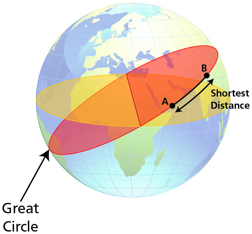
A Great Circle is a circle on the surface of the Earth whose centre and radius are those of the Earth itself. It is called "great" because a disc cut in the plane of the Great Circle would have the largest area achievable — it divides the Earth into two equal hemispheres.
Key properties:
- Shortest distance — the shorter arc of the Great Circle joining two points is the shortest path between them on the Earth's surface.
- Uniqueness — given two non-antipodal points, only one Great Circle joins them.
- Changing direction — a Great Circle track changes direction continuously relative to True North (except along a meridian or the Equator).
2. The Rhumb Line — Definition & Properties
🔎 Definition
A Rhumb Line is a regularly curved line on the surface of the Earth that cuts all meridians at the same angle — a line of constant direction.
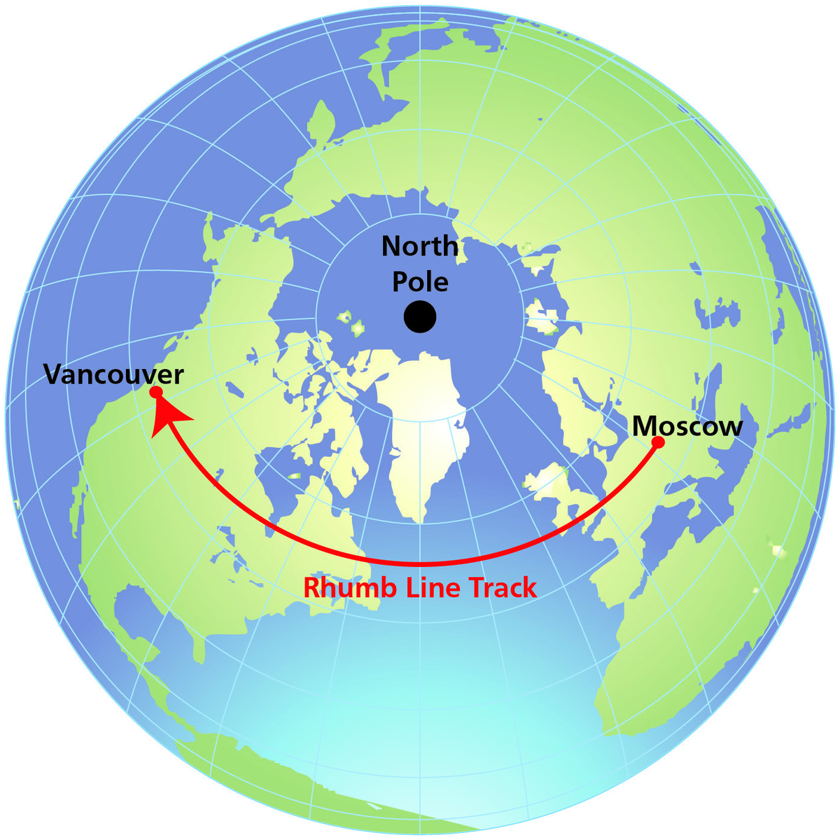
The constant-direction property was enormously important to mariners and early aviators, who navigated by compass heading along straight Mercator chart tracks. Unlike the Great Circle, the Rhumb Line is not the shortest distance (except along the Equator, a meridian, or a parallel of latitude).
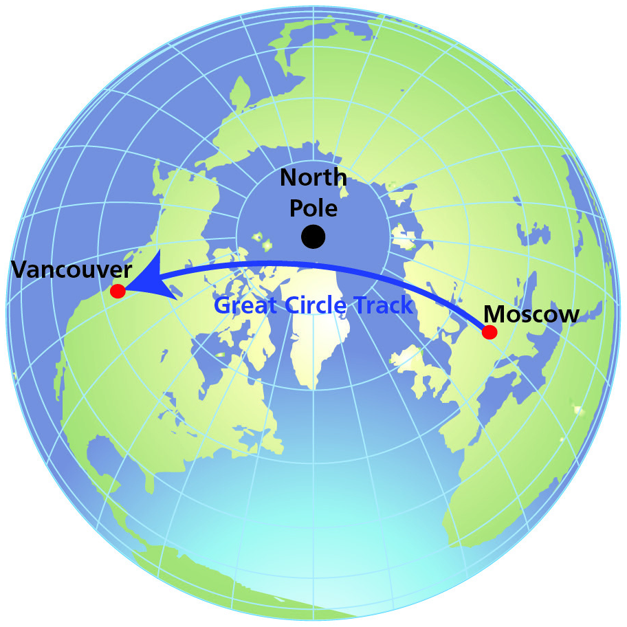
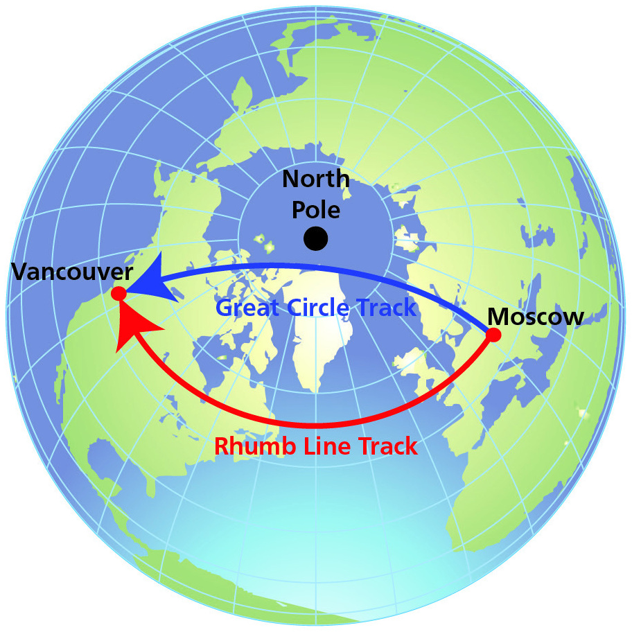
The Great Circle is always the shorter path; the Rhumb Line is always the longer one (again, except for the special cases — Equator, meridians).
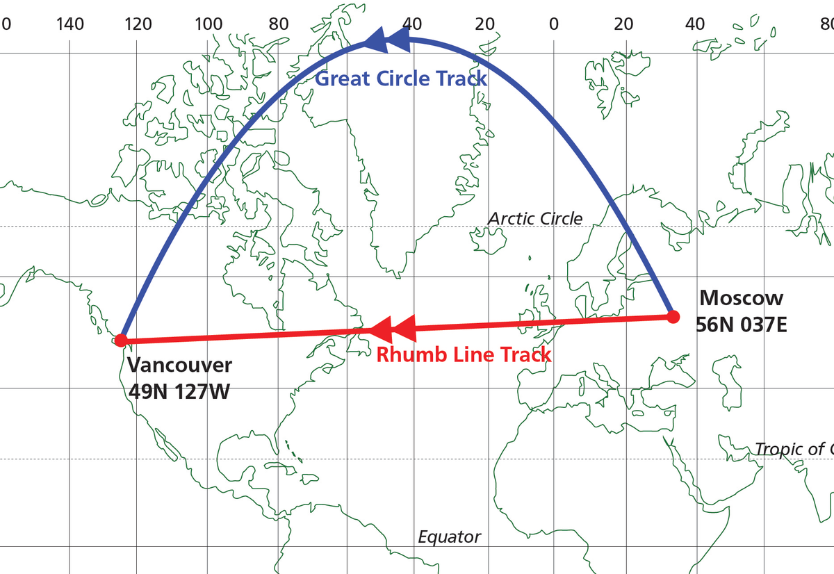
GC vs Rhumb Line — Relative Position
⚠ Critical Exam Rule
- The Great Circle between any two points always lies nearer to the nearer Pole than the Rhumb Line.
- The Rhumb Line always lies nearer to the Equator than the Great Circle.
- In some textbooks: the Rhumb Line is described as convex to the Equator or concave to the nearer Pole.
There is only one Rhumb Line between any two points.
3. Lines That Are Both Great Circles and Rhumb Lines
✈ The Only Two Types
The only lines that are simultaneously Great Circles AND Rhumb Lines are:
- The Equator — cuts all meridians at 90° (Rhumb Line property) AND its plane passes through the Earth's centre (Great Circle property).
- Any Meridian (plus its anti-meridian) — a line of constant direction (0° or 180°) AND a semi-Great Circle.
Note: Parallels of latitude (other than the Equator) are Rhumb Lines but are Small Circles — their plane does not pass through the Earth's centre.
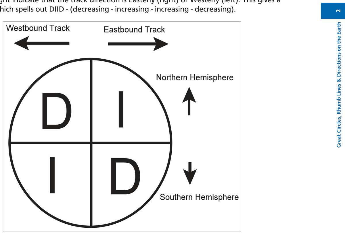
4. Great Circle Direction — The DIID Rule
Because a Great Circle track curves toward the nearer Pole, its direction changes continuously. The pattern of this change is captured in the DIID rule.
Understanding DIID
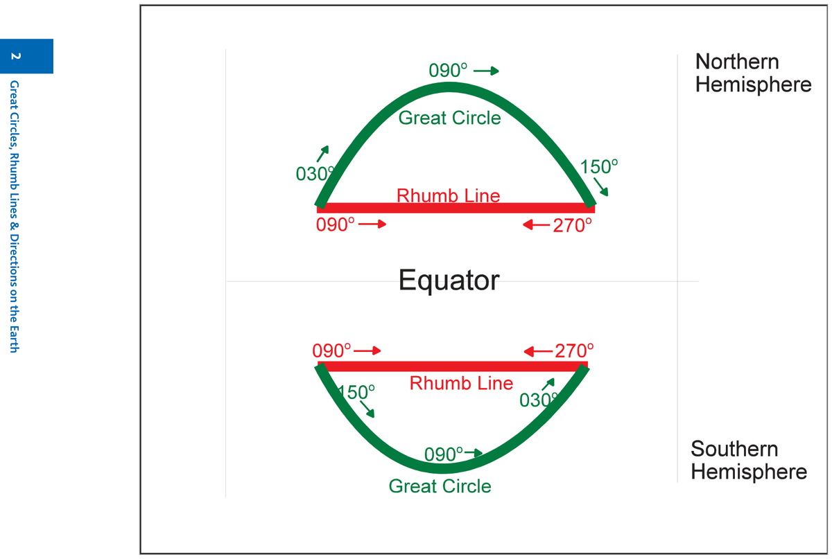
Consider an East–West Rhumb Line track (090° or 270°) at ~50°N or ~50°S:
| Hemisphere | Going East (→) | Going West (←) |
|---|---|---|
| Northern | GC track starts high (030°), swings to 090°, finishes low (150°) — track angle INCREASING | GC track starts low (330°), swings to 270°, finishes high (210°) — track angle DECREASING |
| Southern | GC track starts low (150°), swings to 090°, finishes high (030°) — track angle DECREASING | GC track starts high (210°), swings to 270°, finishes low (330°) — track angle INCREASING |
📚 Reading the DIID Diagram
Reading the four quadrants clockwise from the top-left: D–I–I–D (Decreasing–Increasing–Increasing–Decreasing).
- North + East = Increasing
- North + West = Decreasing
- South + East = Decreasing
- South + West = Increasing
In ALL cases: the GC direction always changes towards the Equator.
5. Distance on the Earth — Units & Conversions
Metric Units
| Unit | Equivalent |
|---|---|
| 1 metre (m) | 100 cm = 1 000 mm |
| 1 kilometre (km) | 1/10 000th of Equator-to-Pole distance → Earth circumference = 40 000 km |
| 1 km | 3 280 ft |
| 1 m | 3.28 ft |
Imperial Units
| Unit | Equivalent |
|---|---|
| 1 foot (ft) | 12 inches |
| 1 yard (yd) | 3 feet |
| 1 inch | 2.54 cm |
| 1 statute mile | 5 280 ft |
The Nautical Mile
✈ The Most Important Aviation Distance Unit
The nautical mile is directly related to the Earth's angular measurements:
- 1 NM = 1 minute of arc on a Great Circle
- ICAO definition: 1 NM = 1 852 metres
- Standard (Admiralty) NM: 1 NM = 6 080 ft
- 1 minute of latitude = 1 NM (everywhere, since all meridians are Great Circles)
- 1 minute of longitude = 1 NM only at the Equator
| Angular Measurement | Distance |
|---|---|
| 1° of latitude | 60 NM |
| Equator to either Pole (90°) | 5 400 NM |
| Earth circumference (360°) | 21 600 NM |
6. Variations in the Length of a Nautical Mile
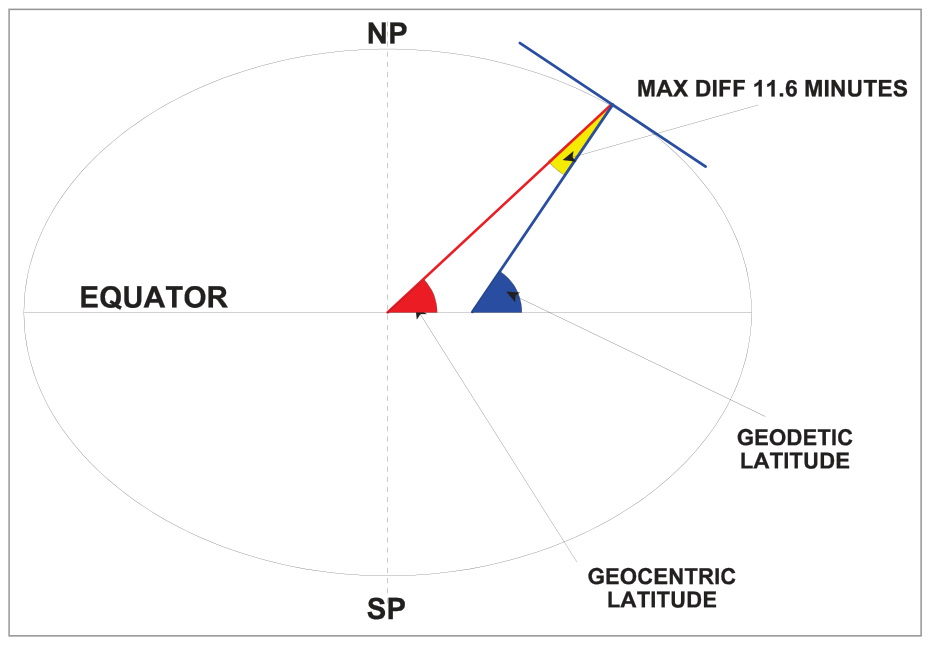
The full definition: the NM is the arc of a Great Circle that subtends 1 minute of arc at the centre of curvature. Because the Earth is an oblate spheroid, the radius of curvature varies with latitude:
| Location | Radius of curvature | NM length |
|---|---|---|
| Equator | Smallest (most curved) | ~6 048 ft (shortest) |
| Standard (mean) | Mean | 6 076.1 ft (International NM = 1 852 m) |
| Poles | Largest (flattest) | ~6 108 ft (longest) |
📚 Exam Use
For all DGCA exam calculations, use the Standard NM of 6 080 ft. The variation between 6 048 ft and 6 108 ft is not examined computationally — it is a conceptual understanding question only.
7. Conversion Factors
| Conversion | Value |
|---|---|
| 5 400 NM = | 10 000 km |
| 21 600 NM = | 40 000 km |
| 1 NM = | 1 852 m = 6 080 ft |
| 1 km = | 3 280 ft |
| 1 km = | 0.5400 NM (= 5400/10000) |
| 1 NM = | 1.852 km |
📚 Ratio Method for NM ↔ km
Use the circumference ratio: 21 600 NM = 40 000 km.
Therefore: NM × (40 000/21 600) = km | km × (21 600/40 000) = NM
Or simply: NM × 1.852 = km | km ÷ 1.852 = NM
8. Great Circle Distances — Six Worked Examples
🔎 Scope of DGCA Exam Questions
General GC distance calculation requires spherical geometry — not in the DGCA syllabus. Exam questions are limited to points on special Great Circles: the same meridian, meridian & anti-meridian, or the Equator. There are five general cases plus a special antipodal case — all six are shown below.
How to Identify Which Case Applies
| Condition | Case |
|---|---|
| Same longitude, same hemisphere | Case 1 — Ch.lat direct |
| Same longitude, different hemispheres | Case 2 — Ch.lat = sum of lats |
| Longitudes add to 180°, same hemisphere | Case 3 — Route via nearer Pole |
| Longitudes add to 180°, different hemispheres | Case 4 — Route via nearer Pole |
| Both at 0° latitude (Equator) | Case 5 — Ch.long at Equator |
| Same lat N & S, lons add to 180° | Case 6 — Antipodal (10 800 NM) |
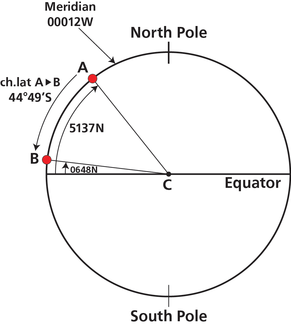
Case 1 — Same Meridian, Same Hemisphere
Example: London (51°37'N 000°12'W) to Accra (06°48'N 000°12'W)
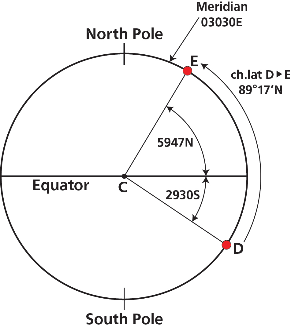
Case 2 — Same Meridian, Different Hemispheres
Example: Durban (29°30'S 030°30'E) to Leningrad (59°47'N 030°30'E)
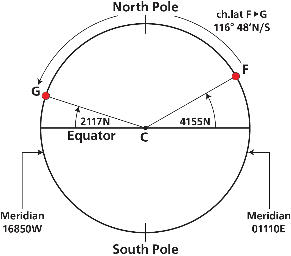
Case 3 — Meridian and Anti-Meridian, Same Hemisphere
Example: Rome (41°55'N 011°10'E) to Honolulu (21°17'N 168°50'W)
Case 4 — Meridian and Anti-Meridian, Different Hemispheres
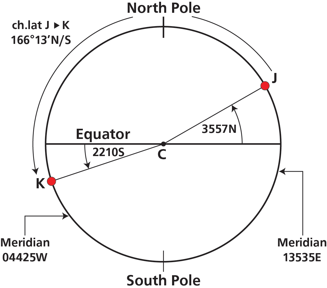
Example: Tokyo (35°57'N 135°35'E) to Rio de Janeiro (22°10'S 044°25'W)
Tokyo → N Pole: 90° − 35°57' = 54°03'
N Pole → Equator: 90°
Equator → Rio: 22°10'
Total: 54°03' + 90° + 22°10' = 166°13'
✎ Self-Check: Wrong-direction check for Case 4
If your angular distance exceeds 180°, you've gone the wrong way around. Subtract from 360° for the angular answer, or subtract from 21 600 NM for the distance.
Case 5 — Two Points on the Equator
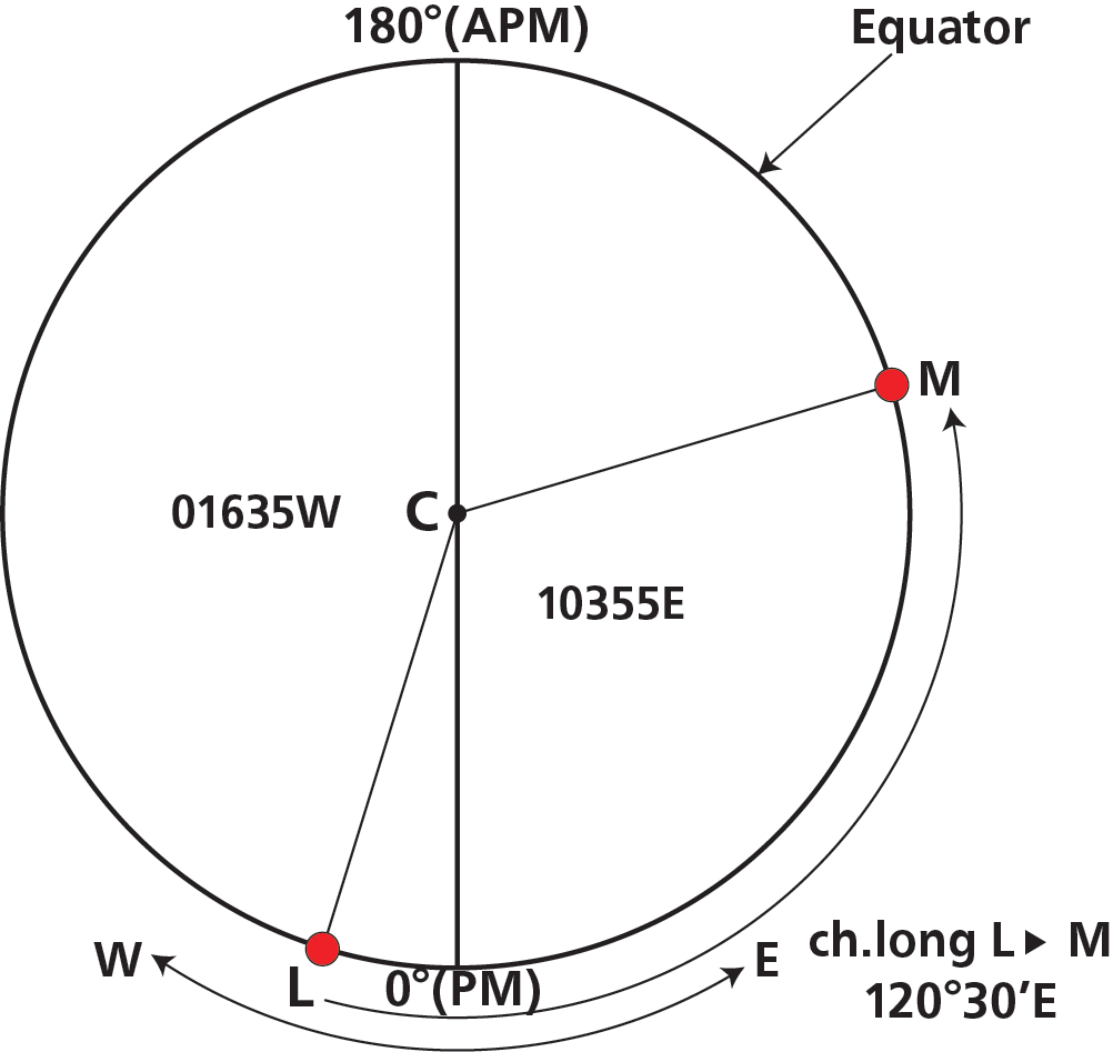
Example: Dakar (00°00'N 016°35'W) to Singapore (00°00'N 103°55'E)
⚠ Only at the Equator!
The conversion 1 minute of longitude = 1 NM is valid ONLY AT THE EQUATOR. At any other latitude, you must use the departure formula (covered in the Departure chapter).
Case 6 — Antipodal Points (Special Case)
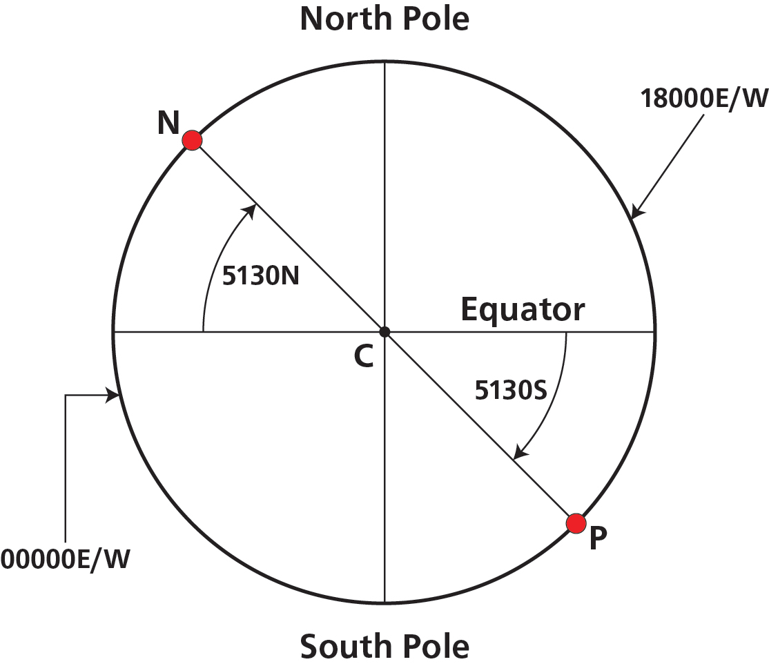
Example: Greenwich (51°30'N 000°00'E) to Antipodes Island (51°30'S 180°00'E)
9. Mean Latitude
The mean latitude between two positions is their arithmetic average. It is used in departure calculations (Ch.15).
Method
- Same hemisphere: add both latitudes, divide by 2.
- Different hemispheres: find the angular span (sum), halve it, subtract from the higher latitude.
✎ Worked Examples
Example 1 — same hemisphere: Mean lat of 52°17'N and 17°57'N
52°17' + 17°57' = 70°14' ÷ 2 = 35°07'N
Example 2 — different hemispheres: Mean lat of 35°25'N and 13°38'S
Total span = 35°25' + 13°38' = 49°03'. Half = 24°31.5'.
Mean lat = 35°25'N − 24°31.5' = 10°53.5'N
📚 Quick Revision Summary — Chapter 2
- GC = shortest distance; constant direction = Rhumb Line
- Rhumb Line is always nearer the Equator than the GC
- GC always nearer the Pole than the Rhumb Line
- Only lines that are both GC and Rhumb Line: Equator and meridians
- DIID: North East = Increasing, North West = Decreasing, South East = Decreasing, South West = Increasing
- GC direction always changes towards the Equator
- 1 NM = 1 852 m = 6 080 ft (standard); Earth = 21 600 NM = 40 000 km
- NM length: shortest at Equator (6 048 ft), longest at Poles (6 108 ft)
- Meridian+anti-meridian condition: longitudes of opposite signs that sum to 180°
- Case 3/4: GC always goes via the nearer Pole
- Antipodal: 10 800 NM (always)
Practice Questions & Detailed Answers
11 questions (many with sub-parts) • Calculation, conceptual & MCQ • Full worked solutions
(a) 52°15'N to 39°35'N (b) 49°35'N to 60°20'S (c) 74°20'S to 34°30'S (d) 71°20'N to 86°45'N over the North Pole
▶ Show answer & explanation
| Part | Calculation | Answer |
|---|---|---|
| (a) | 52°15' − 39°35' = 12°40' South | 12°40'S |
| (b) | 49°35'N + 60°20'S (cross Equator) = 109°55' South | 109°55'S |
| (c) | 74°20'S → 34°30'S: 74°20' − 34°30' = 39°50' North | 39°50'N |
| (d) | 71°20'N→Pole: 18°40' + Pole→86°45'N: 3°15' = 21°55' | 21°55' |
Part (b) note: When crossing the Equator, add both latitudes (49°35' + 60°20' = 109°55').
Part (c) note: Both in Southern hemisphere — the aircraft travels northward (toward less southerly latitude). Subtract the smaller from the larger: 74°20' − 34°30' = 39°50'N.
Part (d) note: "Over the North Pole" means the route passes through 90°N and continues on the opposite meridian. From 71°20'N to the pole = 18°40'; pole to 86°45'N = 3°15'. Total = 21°55'.
▶ Show answer & explanation
Step 1 — Ch.lat: 79°30' − 41°25' = 38°05'N
Step 2 — NM: (38 × 60) + 5 = 2 285 NM
Step 3 — km: 2 285 × 1.852 = 4 232 km (or 4 230 km using the nav computer)
(a) 075°40'W to 125°35'W (b) 001°20'E to 004°20'W (c) 150°40'E to 179°30'E (d) 162°36'W to 140°42'E
▶ Show answer & explanation
| Part | Calculation | Answer |
|---|---|---|
| (a) | 125°35' − 075°40' = 49°55' West (same side) | 49°55'W |
| (b) | 001°20' + 004°20' = 05°40' West (opposite sides) | 05°40'W |
| (c) | 179°30' − 150°40' = 28°50' East (same side) | 28°50'E |
| (d) | 162°36' + 140°42' = 303°18' → shorter arc: 360° − 303°18' = 56°42'W | 56°42'W |
Rule: same side → subtract; opposite sides → add. If the result exceeds 180°, take the supplement (360° − result) — this is the shorter arc.
Part (d) detailed: 162°36'W and 140°42'E are on opposite sides, so add: 162°36' + 140°42' = 303°18'. Since 303°18' > 180°, the shorter arc is 360° − 303°18' = 56°42'. Going westward from 162°36'W by 56°42' takes you through the anti-meridian to 140°42'E.
(a) 50°31'N 006°30'W → 52°00'N 008°35'W
(b) 47°32'N 002°46'W → 43°56'N 001°33'W
(c) 61°47'N 003°46'W → 62°13'N 001°36'E
(d) 31°27'S 091°47'E → 35°57'N 096°31'E
(e) 51°05'N 177°42'E → 51°06'N 167°42'W
▶ Show answer & explanation
| Part | Ch.lat | Ch.long |
|---|---|---|
| (a) | 01°29'N | 002°05'W |
| (b) | 03°36'S | 001°13'E |
| (c) | 00°26'N | 005°22'E |
| (d) | 67°24'N | 004°44'E |
| (e) | 00°01'N | 014°36'E |
(a) Lat: 52°00' − 50°31' = 01°29'N. Long: 008°35'W − 006°30'W = 002°05'W (going further west).
(b) Lat: 43°56' − 47°32' = 03°36'S (going south). Long: 002°46'W → 001°33'W = 001°13'E (going east, less westerly).
(c) Lat: 62°13' − 61°47' = 00°26'N. Long: 003°46'W + 001°36'E = 005°22'E (crossing prime meridian).
(d) Lat: 35°57'N + 31°27'S = 67°24'N (cross Equator northbound). Long: 096°31' − 091°47' = 004°44'E.
(e) Lat: 51°06' − 51°05' = 00°01'N. Long: 177°42'E → 167°42'W — going east: 177°42'E to 180° = 2°18', then 180° to 167°42'W = 12°18'. Total = 014°36'E (shorter arc eastward).
(a) 52°06'N 002°32'E and 53°36'N 002°32'E (b) 04°41'S 163°36'W and 03°21'N 163°36'W
(c) 62°00'N 093°00'E and 62°00'N 087°00'W (d) 00°00'N 176°00'E and 00°00'N 173°00'W
(e) 43°57'N 071°37'W and 43°57'S 108°23'E
▶ Show answer & explanation
| Part | Case | NM | km |
|---|---|---|---|
| (a) | Case 1 (same meridian, same hemi) | 90 NM | 167 km |
| (b) | Case 2 (same meridian, diff hemi) | 482 NM | 893 km |
| (c) | Case 3 (merid+anti-merid, same hemi) | 3 360 NM | 6 223 km |
| (d) | Case 5 (Equator) | 660 NM | 1 222 km |
| (e) | Case 6 (Antipodal) | 10 800 NM | 20 000 km |
(a) Same lon 002°32'E. Ch.lat = 53°36' − 52°06' = 01°30' = 90 NM. × 1.852 = 167 km.
(b) Same lon 163°36'W. Ch.lat = 04°41' + 03°21' = 08°02' = 482 NM. × 1.852 = 893 km.
(c) 093°00'E + 087°00'W = 180° → Case 3. Both 62°N → route over N Pole. Angular = 180° − (62° + 62°) = 56° = 3 360 NM. × 1.852 = 6 223 km.
(d) Both on Equator → Case 5. Ch.long: 176°E + 173°W = 349°; shorter arc = 360° − 349° = 11°. At Equator: 11° × 60 = 660 NM. × 1.852 = 1 222 km.
(e) 071°37'W + 108°23'E = 180° AND equal lats N/S → Antipodal (Case 6). Distance = 180° = 10 800 NM = 20 000 km.
(a) Give the initial True track direction. (b) Will the track direction remain the same? (c) Why/why not?
▶ Show answer & explanation
(a) Initial track: 360°(T) — True North
(b) Track changes: No
(c) Route is over the North Pole. Initial track is True North; once past the pole, the track becomes True South (180°T).
Step 1 — Identify case: 002°30'E + 177°30'W = 180° → meridian/anti-meridian. Both at 72°N → same hemisphere → Case 3 (route over North Pole).
Step 2 — Initial direction: From 72°N heading to the North Pole = due North = 360°(T).
Step 3 — Track consistency: As the aircraft crosses the pole, "north" flips to "south" on the Mercator representation. The track direction changes from 360°T to 180°T — so No, it does not remain constant.
▶ Show answer & explanation
Latitude: 54°20'N + 16°20'N = 70°40'N
Longitude: 002°30'W + 20°30'W = 023°00'W
▶ Show answer & explanation
Latitude: 36°47'S + 46°47'N (northward change crosses Equator): 46°47' − 36°47' = 10°00'N
Longitude: 179°21'E + 20°30'E = 199°51'E. Since > 180°: 360° − 199°51' = 160°09'W
(a) In the Northern hemisphere (b) In the Southern hemisphere
▶ Show answer & explanation
(a) Northern hemisphere: Rhumb Line is nearer the Equator (South of the Great Circle)
(b) Southern hemisphere: Rhumb Line is nearer the Equator (North of the Great Circle)
In both hemispheres, the Rhumb Line lies nearer to the Equator, while the Great Circle bulges toward the nearer Pole. This is why the GC is the shorter path — it cuts across the "top" of the curved path rather than staying at the lower latitude.
▶ Show answer & explanation
A meridian is simultaneously both:
- A Rhumb Line — it cuts all other meridians at a constant angle of 0° (it runs exactly N–S, maintaining constant direction).
- A semi-Great Circle — it forms one half of a Great Circle (the other half being its anti-meridian), whose plane passes through the Earth's centre.
(a) Correct but incomplete — a meridian is also a semi-Great Circle.
(b) Correct but incomplete — a meridian is also a Rhumb Line.
▶ Show answer & explanation
Cutting all meridians at the same angle is equivalent to maintaining a constant compass direction. This is the defining property of a Rhumb Line and the basis of traditional compass navigation.
(a) Wrong — constant direction gives the longer (Rhumb Line) path, not the shortest (Great Circle).
(b) Wrong — meridians cut all other meridians at 0° (a constant angle) AND are semi-Great Circles. So a Rhumb Line CAN be a Great Circle track.
Master Reference Tables — Chapter 2
All Key Numerical Values
| Parameter | Value | Section |
|---|---|---|
| 1 NM (ICAO) | 1 852 m | §5 |
| 1 NM (Standard/Admiralty) | 6 080 ft | §5 |
| 1 NM (at Equator) | ~6 048 ft (shortest) | §6 |
| 1 NM (International mean) | 6 076.1 ft | §6 |
| 1 NM (at Poles) | ~6 108 ft (longest) | §6 |
| Earth circumference | 21 600 NM = 40 000 km | §7 |
| Equator to Pole | 5 400 NM = 10 000 km | §7 |
| 1 km | 3 280 ft = 0.5400 NM | §7 |
| 1 m | 3.28 ft | §5 |
| 1 inch | 2.54 cm | §5 |
| 1 statute mile | 5 280 ft | §5 |
| Antipodal distance | 10 800 NM = 20 000 km | §8 |
GC Distance Cases — Quick Decision Tree
| Test | Case | Method |
|---|---|---|
| Same longitude, both same hemi | Case 1 | Ch.lat → NM |
| Same longitude, different hemi | Case 2 | Sum lats → NM |
| Lons add to 180°, same hemi | Case 3 | 180° − sum of lats → NM |
| Lons add to 180°, diff hemi | Case 4 | Draw diagram, route via nearer Pole |
| Both at Equator (lat = 0) | Case 5 | Ch.long (shorter arc) → NM |
| Equal lats N & S, lons add to 180° | Case 6 | Always 10 800 NM |
DIID Rule — GC Track Direction Change
| Hemisphere + Direction | GC Track Angle |
|---|---|
| North + East (→) | Increasing |
| North + West (←) | Decreasing |
| South + East (→) | Decreasing |
| South + West (←) | Increasing |
GC always changes direction towards the Equator. Mnemonic: DIID read from North-West clockwise.
Answer Key Summary — No ⚑ Flags
| Q | Answer(s) |
|---|---|
| 1 | a) 12°40'S b) 109°55'S c) 39°50'N d) 21°55' |
| 2 | 2 285 NM | 4 232 km |
| 3 | a) 49°55'W b) 05°40'W c) 28°50'E d) 56°42'W |
| 4 | a) 01°29'N 002°05'W b) 03°36'S 001°13'E c) 00°26'N 005°22'E d) 67°24'N 004°44'E e) 00°01'N 014°36'E |
| 5 | a) 90/167 b) 482/893 c) 3 360/6 223 d) 660/1 222 e) 10 800/20 000 |
| 6 | a) 360°(T) b) No c) Over N Pole, then track reverses to 180°T |
| 7 | 70°40'N 023°00'W |
| 8 | 10°00'N 160°09'W |
| 9 | a) Nearer Equator (S of GC) b) Nearer Equator (N of GC) |
| 10 | c |
| 11 | c |
Chapter 2 — Great Circles, Rhumb Lines & Directions on the Earth
Ghost Aviator | www.ghostaviator.com
For personal study use only. Ghost Aviator Interactive Colour Edition.
Reinforce Chapter 2: Great Circles, Rhumb Lines & Directions on the Earth
Test your knowledge and practice actual exam questions for Air Navigation.