Air is a poor conductor of heat. A small rising or falling parcel of air in atmospheric processes can be regarded as insulated from its surroundings.
Process
Definition
Heat Exchange
Isothermal
Heat is allowed to enter or leave the system — temperature remains the same
Yes (with surroundings)
Adiabatic
No heat enters or leaves the system. (Greek: a = not, diabano = pass through)
No (insulated)
Adiabatic Process explained: If a parcel of air ascends adiabatically, it moves into a region of lower pressure and expands. The work done in expanding is at the expense of its internal energy → temperature falls. Conversely, descending air is compressed → temperature rises. Adiabatic processes, to a large extent, determine the vertical distribution of temperature in the atmosphere.
2. Lapse Rates
Lapse Rate (LR): Decrease of temperature with height. Taken positive when temperature decreases with height. Average LR in the troposphere is about 6.5°C/km.
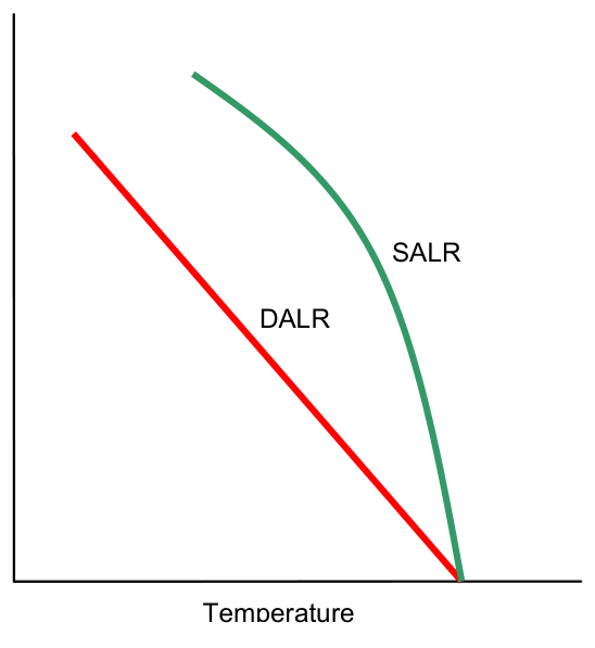
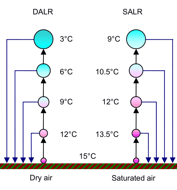
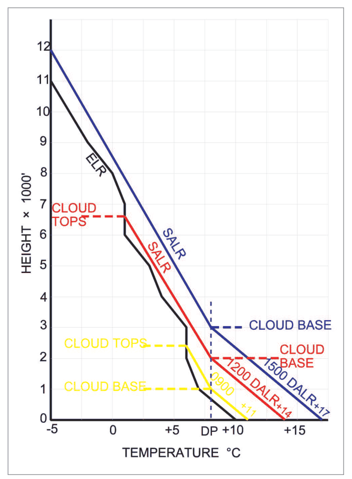
DALR and SALR on a temperature-height graphDry and saturated parcel coolingEnvironmental lapse rate, DALR and SALR
Three Key Lapse Rates
DALR — Dry Adiabatic Lapse Rate
Rate of temperature decrease with height when unsaturated air ascends adiabatically.
Value = 9.8°C/km = 3°C/1000 ft
(In ISA: ELR = 6.5°C/km)
SALR — Saturated Adiabatic Lapse Rate
When saturated air lifts adiabatically → water vapour condenses → latent heat released → offsets adiabatic cooling.
Value ≈ 5°C/km (variable — generally increases as the rising air becomes colder, approaching DALR)
At higher levels (low temperatures), very little WV → latent heat small → SALR approaches DALR.
ELR — Environmental Lapse Rate
Actual lapse rate existing in the atmosphere. In ISA, ELR = 6.5°C/km.
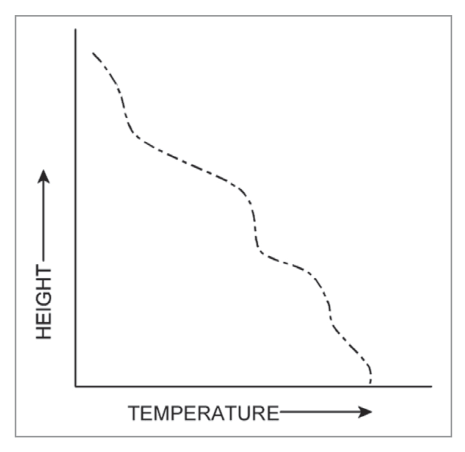
In actual atmosphere: can be any value. It may be super-adiabatic (temperature decreases faster than DALR), zero (isothermal), or negative (an inversion).
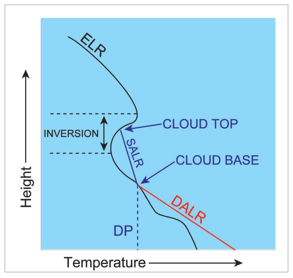
Inversion: Increase of temperature with height (negative lapse rate). Opposite of normal.
Variable environmental lapse rateInversion limiting cloud top
Inversion Layer
An atmospheric layer in which there is an inversion of temperature. Vertical motion through such a layer is inhibited due to stability in the layer. An inversion layer near the Earth's surface occurs during cloudless cool nights. Inversion at higher levels is associated with anticyclones and sometimes with the fronts.
Effects of Inversion
Type
Common Occurrence
Aviation Effect
Low level inversion
Common during winters due to nocturnal cooling. Also associated with ridges, high pressure areas and anticyclones.
Smoke, haze, mist, fog stagnate over ground → poor visibility. Often at top of stratified cloud layer.
Higher level inversion
Associated with anticyclones, sometimes fronts
Does not allow surface air to rise and mix with upper winds → smoke/pollution trapped below
Key Point: Inversion indicates stability and lack of turbulence in the atmosphere. However, low level inversion causes poor visibility — haze, mist, fog, smoke stagnate — especially radiation fog. Inversion is often present at the top of a stratified cloud layer.
4. Stability and Instability
Stable atmosphere analogy: A glass ball placed at centre of a convex glass — displaced and left, it will oscillate and return to original position (like a pendulum). Stratosphere and Thermosphere are stable atmospheres.
Unstable atmosphere analogy: A glass ball placed at top of an inverted watch-glass — if displaced will roll down further, will NOT return to original position.
Atmospheric Instability
A layer is stable if a parcel of air in it, given a small push upwards, sinks back to its original level. It is neutral if it continues to move at its new level. It is unstable if it continues to move up at its own.
To estimate static stability in a layer, changes in KE of a test parcel at various levels are estimated from the Aerological Diagram (T-phi gram / Tephigram).
The atmosphere is stable, neutral or unstable according as the KE of the parcel decreases, remains constant or increases — A fall of temperature with height alone does not establish instability: compare the environmental lapse rate with the dry and saturated adiabatic rates.
5. Types of Instability/Stability
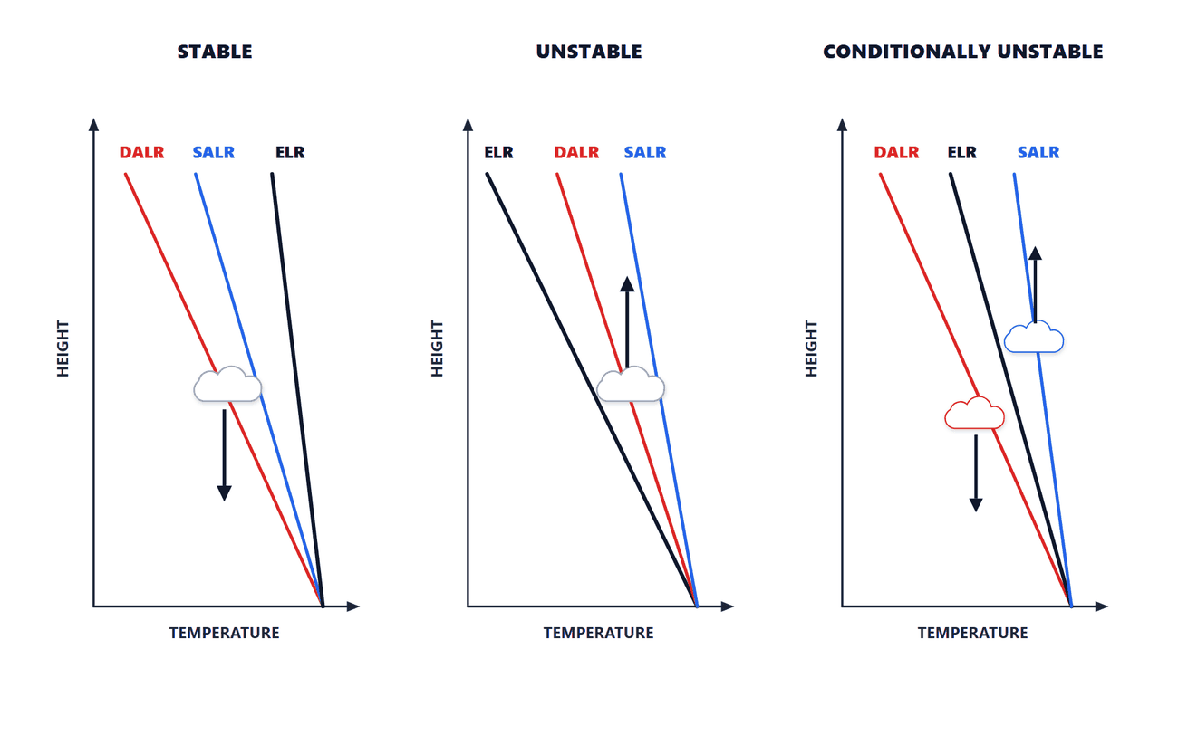
Conditional Instability: State of atmosphere in which DALR > ELR > SALR. Atmosphere is unstable for saturated air and stable for unsaturated air.
Stable, unstable and conditionally unstable air
Latent Instability: An atmospheric layer in an initially stable parcel of air that eventually becomes unstable due to forced ascent. The parcel possesses latent (hidden) instability. It is Real Latent if force required to lift is much less than energy released when it becomes unstable. It is Pseudo Latent if energy required to lift > energy released later.
Potential (Convective) Instability: When a layer as a whole if lifted bodily becomes unstable if latent heat released on lifting produces sufficient temperature difference between bottom and top of layer to steepen LR of lifted layer. For potential instability it is essential that RH is high in lower levels and low in higher levels.
6. Stability Criteria
STABILITY CRITERIA TABLE
Condition
Stability Status
When (ELR relation)
Dry air is
Stable
DALR > ELR
Saturated air is
Stable
SALR > ELR
Air (Dry or Saturated) is
Absolutely Stable
SALR > ELR (both dry and sat stable)
Air (Dry or Saturated) is
Absolutely Unstable
ELR > DALR
Conditional Instability
Unstable for sat; stable for dry
DALR > ELR > SALR
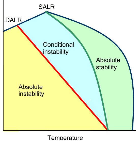
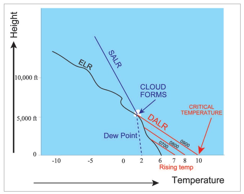
Stability regions by ELRCondensation level and critical temperature
flowchart TD
    A[ELR value?] --> B{Compare with SALR and DALR}
    B -->|ELR < SALR| C[ABSOLUTELY STABLE
Both dry and sat air stable]
    B -->|SALR < ELR < DALR| D[CONDITIONALLY UNSTABLE
Stable for dry, unstable for saturated]
    B -->|ELR > DALR| E[ABSOLUTELY UNSTABLE
Both dry and sat air unstable]
    C --> F[Fine wx, stratiform clouds]
    D --> G[Thunderstorm if forced uplift + moisture]
    E --> H[Severe convection, CB, TS]
Key Stability Rule:
DALR = 9.8°C/km (fixed)
SALR ≈ 5°C/km (variable)
ELR = actual measured value
If ELR < SALR → Absolutely Stable (AS on both accounts) If SALR < ELR < DALR → Conditionally Unstable If ELR > DALR → Absolutely Unstable
When a parcel of dry air is lifted, it follows DALR. Saturated air follows SALR. Comparing the temperature of the lifted parcel (as given by DALR/SALR) with the environmental temperature (ELR) at any level AB (Figure 9.1): if parcel temperature is more than environmental → parcel will shoot up = Unstable. If colder → it will sink = Stable.
7. Tephigram (T-phi Gram)
Tephigram: A thermodynamic diagram on which upper air temperatures, winds and dew point temperatures (as obtained from Radiosondes and Rawin) are plotted at various levels. Used for estimating meteorological parameters viz. Instability-Stability in the atmosphere, Mintra Level, LCL, base and top of cloud, Potential and Latent Instability, wet bulb temperature etc.
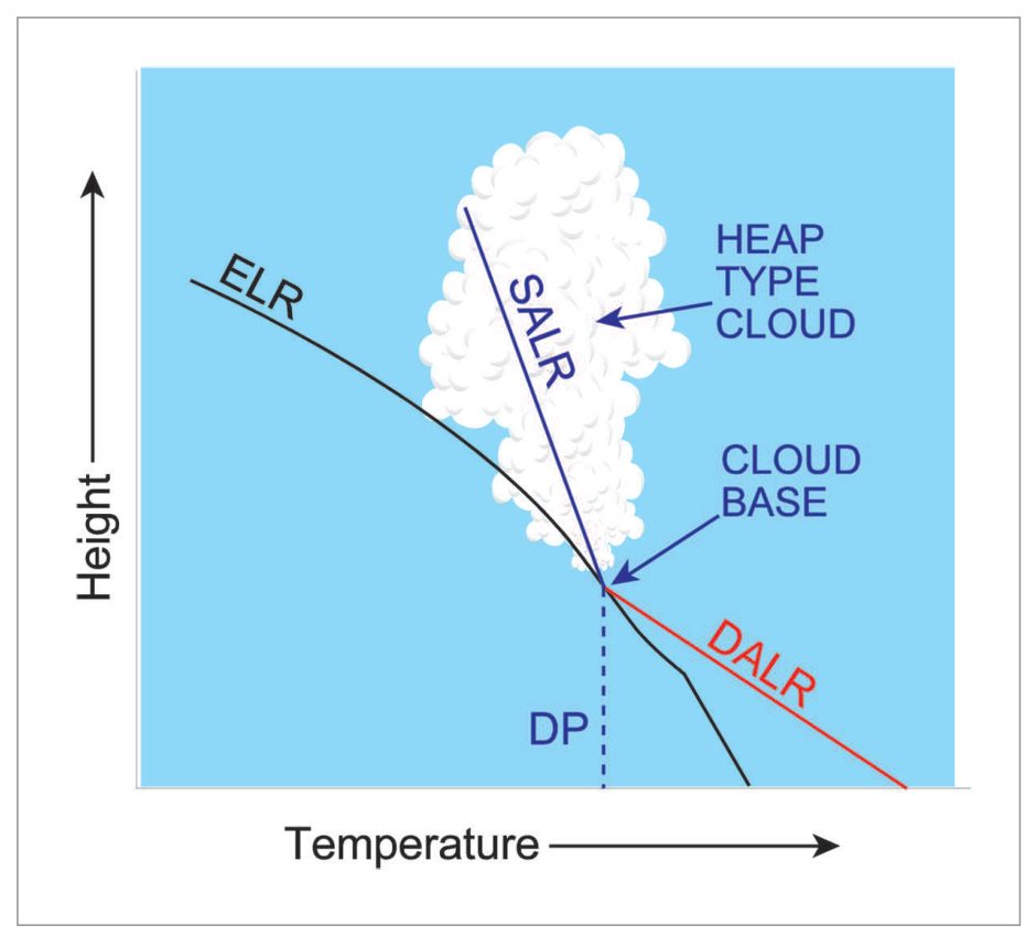
Finding cloud base and tops on a temperature-height diagram
Lines on Tephigram (used in India)
Line Type
Represents
Horizontal Lines
Potential Temperature or DALR
Vertical Lines
Temperature
Slanting Lines 45° to DALR
Pressure at different levels
Curved lines slanting left (gradually becoming parallel to DALR at higher levels)
SALR lines
Dashed lines slightly slanting left
Isohygric lines (lines of equal saturation mixing ratio — g/kg)
Separate lines exist for saturation over water and over ice on the Tephigram.
8. Normand Theorem and Normand Point
Normand Theorem: If we draw upwards DALR from dry bulb (TT), SALR from wet bulb (TwTw), and Isohygric from dew point (TdTd) temperatures, the three lines meet at a point called the Normand Point. By knowing TT and TdTd, we can calculate TwTw at any level.
LCL (Lifting Condensation Level): The first Normand Point (from the surface) is the First Normand Point. This is also called the Lifting Condensation Level (LCL) and gives an idea of the height at which cloud may form.
Exam Tip: LCL = level where rising parcel first becomes saturated = cloud base height. Found using Tephigram by intersection of DALR (from TT), SALR (from TwTw) and Isohygric (from TdTd).
The environmental lapse rate (6.8 °C/km) is less than the dry adiabatic lapse rate (9.8 °C/km). A lifted unsaturated parcel cools faster than its surroundings, becomes heavier and sinks back, so the atmosphere is stable for dry air. (If the air is saturated, the saturated rate of about 5 °C/km is smaller than 6.8, and the same atmosphere is conditionally unstable.)
❌ (b) Unstable would need the environmental lapse rate to exceed the dry adiabatic rate.
💡 ELR less than DALR = stable for dry air. ELR more than SALR but less than DALR = conditionally unstable.
This is the definition of Conditional Instability: DALR > ELR > SALR. Stable for dry air, unstable for saturated air.
🎯 DALR > ELR > SALR = CONDITIONAL. Think: "conditionally" based on whether air is saturated or not.
Q4. Dry air is unstable when (a) ELR = DALR (b) ELR > DALR (c) ELR < DALR
✅ Answer: (b) ELR > DALR
Dry air is unstable when ELR > DALR (Absolutely Unstable). The environment is cooling faster than the parcel → parcel remains warmer than surroundings → keeps rising.
Q5. The saturated air is said to be unstable if (a) SALR = ELR (b) SALR < ELR (c) SALR > ELR
✅ Answer: (b) SALR < ELR
If SALR < ELR, the environment cools faster than the saturated parcel → parcel remains warmer → unstable.
🎯 For BOTH dry and saturated: if ELR > your lapse rate → unstable. ELR > SALR → saturated air unstable.
Q6. If ELR = SALR = DALR the atmosphere is (a) Stable (b) Indifferent (c) Unstable
✅ Answer: (b) Indifferent (Neutral)
When all three lapse rates are equal, the parcel neither accelerates upward nor downward — neutral/indifferent equilibrium.
🎯 All equal = neutral. Parcel displaced stays at new level without returning or ascending further.
Q7. DALR means (a) Rate at which temperature of unsaturated parcel of air falls with height when made to ascend adiabatically (b) Rate at which temp falls with height (c) Rate at which ascending parcel of saturated air cools
✅ Answer: (a)
DALR = Dry Adiabatic Lapse Rate = rate of cooling of unsaturated air ascending adiabatically = 9.8°C/km.
(b) = ELR definition; (c) = SALR definition.
🎯 D = Dry (unsaturated). A = Adiabatic. LR = Lapse Rate. Value = 9.8°C/km = 3°C/1000 ft.
Q8. Surface temp 30°C. Assuming DALR, temperature at 2 km is (a) 18°C (b) 10°C (c) 42°C
✅ Answer: (b) 10°C
T at 2 km = 30 − (9.8 × 2) = 30 − 19.6 ≈ 10°C
🎯 DALR = 9.8°C/km. Multiply by height in km and subtract from surface temp.
Q9. An Isothermal atmosphere is (a) Stable (b) Unstable (c) Neutral
✅ Answer: (a) Stable
Isothermal = ELR = 0. Since DALR (9.8) > ELR (0), dry air is stable. Since SALR (~5) > ELR (0), saturated air also stable → Absolutely Stable.
🎯 Isothermal → ELR = 0 → less than both DALR and SALR → Absolutely Stable.
Q10. If ELR is less than SALR, atmosphere is said to be (a) Absolutely unstable (b) Conditionally unstable (c) Absolutely stable
✅ Answer: (c) Absolutely stable
ELR < SALR means environment cools slower than even saturated air → both dry and saturated air parcels are stable → Absolutely Stable.
🎯 ELR < SALR < DALR → Absolutely Stable → no convection possible → stratiform clouds, radiation fog.
Q11. DALR is approximately (a) 5°C/km (b) 15°C/km (c) 10°C/km
✅ Answer: (c) 10°C/km (closest to 9.8°C/km)
DALR = 9.8°C/km ≈ 10°C/km. In some textbooks/exams rounded to 10°C/km.
Q12. SALR at mean sea level is about (a) 10°C/km (b) 5°C/km (c) 5°F/km
✅ Answer: (b) 5°C/km
SALR near sea level where temperatures are warm and moisture is abundant is approximately 5°C/km. It varies and approaches DALR at high altitudes.
🎯 SALR = ~5°C/km at MSL. Decreases toward DALR as altitude increases and moisture decreases.
Q13. SALR approaches DALR (a) at −15°C (b) at −40°C
✅ Answer: (b) at −40°C
At higher levels where temperature is below −40°C, very little water vapour is present → latent heat released on condensation is negligible → SALR approaches DALR (9.8°C/km).
Q14. Dry air having a temp of 35°C on surface when forced to rise adiabatically by 1 km would attain a temp of (a) 29°C (b) 25°C (c) 45°C
✅ Answer: (b) 25°C
T = 35 − (9.8 × 1) = 35 − 9.8 = 25.2°C ≈ 25°C
🎯 DALR: subtract 9.8°C (≈10°C) per km ascent.
Q15. Inversion in the atmosphere indicates (a) Stability (b) Instability (c) Neutrality
✅ Answer: (a) Stability
Inversion = temperature increases with height = ELR is negative = highly stable condition. Vertical motion is inhibited through an inversion layer.
🎯 Inversion = Stability = Fog/Smog trap = poor visibility but no convection.
Q16. Environmental LR can be more than DALR (a) True (b) False
✅ Answer: (a) True
ELR can be more than DALR — this is called super-adiabatic lapse rate, creating Absolutely Unstable atmosphere. Common in very hot surface conditions.
🎯 Super-adiabatic ELR (>9.8°C/km) = dangerous convection. Rare but possible on very hot days.
Q18. The process which to a large extent determines the vertical distribution of temperature in atmosphere is (a) Adiabatic (b) Isothermal (c) Isentropic
✅ Answer: (a) Adiabatic
Adiabatic processes — DALR and SALR — determine vertical temperature distribution in the troposphere. Isothermal processes do not; isentropic is the same as adiabatic in many contexts but adiabatic is the key term here.
🎯 Adiabatic processes = the key to atmospheric temperature distribution = pilot exam staple.
Q19. Rise in temperature with height is (a) Lapse (b) Normal (c) Inversion
✅ Answer: (c) Inversion
Lapse = fall with height (normal). Rise with height = Inversion (abnormal, negative lapse rate).
🎯 Temperature rises with height = INVERSION. Always exam-worthy.
Q20. Inversion is common in (a) Post Monsoon (b) Monsoon (c) Winters
✅ Answer: (c) Winters
Low level inversion is common during winters due to nocturnal cooling of the surface, resulting in surface temperatures lower than air above. This traps fog and haze.