Convergency and Conversion Angle
by Ghost Aviator
Conversion Angle
Meridians and Convergency
Meridians are great semi-circles that join the geographic North and South Poles. Because they all connect at the same two points, they cannot remain parallel to each other — they must converge at the poles. Understanding exactly how much they converge, and at what rate, is fundamental to great circle navigation.
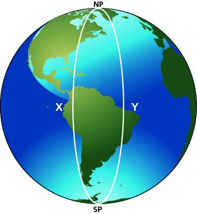
Figure 1 — Meridians diverge from the North Pole, are parallel at the Equator, then converge again toward the South Pole
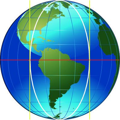
Figure 2 — At the Equator, any two meridians are exactly parallel to each other — convergency is zero
The Three Key Facts About Meridian Convergence
- At the Equator: any two meridians are exactly parallel. No matter how far apart they are in longitude, they never incline toward each other at the Equator. Convergency = 0°.
- At either Pole: meridians converge to a single point. The angle between two meridians at the Pole equals exactly their difference in longitude. If two meridians are 60° of longitude apart, they meet at the Pole at an angle of exactly 60°. Convergency = Change of Longitude.
- At intermediate latitudes: convergency is between 0° and the change of longitude — proportional to the sine of the latitude.
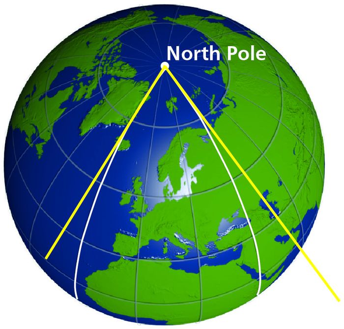
Figure 3 — At the Pole, the angle between two meridians equals exactly their change of longitude
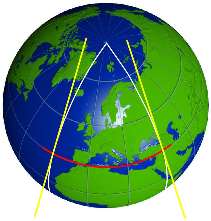
Figure 4 — At intermediate latitude, convergency is proportionally between 0° (Equator) and ch.long (Pole)
The Convergency Formula
From the observations above, convergency varies between zero (at the Equator) and the full change of longitude (at the Poles). The factor that controls this is the sine of the latitude. This leads directly to the formula:
Why Sine of Latitude?
The sine function has exactly the right behaviour: sin(0°) = 0 at the Equator, and sin(90°) = 1.0 at the Poles. At 30°N, sin(30°) = 0.5, so convergency is exactly half the change of longitude. At 45°N, sin(45°) = 0.707, so convergency is about 70.7% of the change of longitude.
| Latitude | sin(lat) | Effect on Convergency |
|---|---|---|
| 0° (Equator) | 0.000 | No convergency |
| 20° | 0.342 | 34.2% of ch.long |
| 30° | 0.500 | 50% of ch.long |
| 45° | 0.707 | 70.7% of ch.long |
| 60° | 0.866 | 86.6% of ch.long |
| 90° (Pole) | 1.000 | 100% of ch.long |
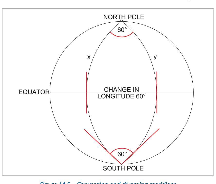
Figure 5 — Convergency shown as the angle of inclination between two meridians — with worked table showing values at Equator (0) and Pole (1.0)
The 30°N Worked Example
Consider two meridians 40° of longitude apart, at latitude 30°N:
Calculation
Convergency = Change of Longitude × sin(Latitude)
Convergency = 40° × sin(30°) = 40° × 0.5 = 20°
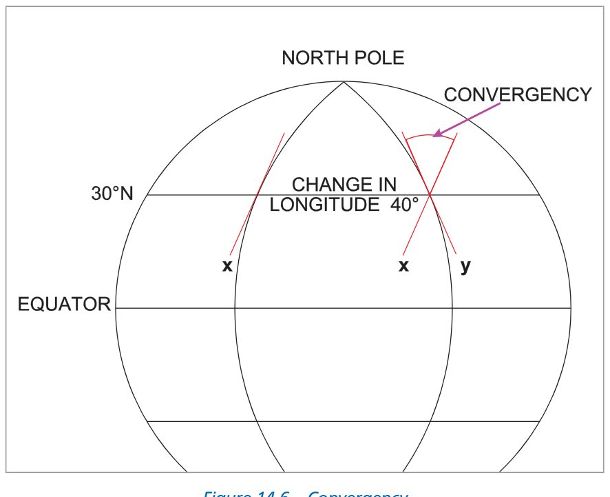
Figure 6 — Tangents drawn to two meridians at 30°N — the angle between them is 20° (= 40° × 0.5)
When the Two Points are at Different Latitudes
In practice, most great circle routes go from one latitude to another — the two endpoints are not on the same parallel. In this case there is no single "latitude" to insert in the formula. The rigorous solution requires the mean latitude of the great circle route itself, which is closer to the nearer pole than the mid-latitude between the two endpoints.
However, the difference between sine of mid-latitude and sine of mean latitude is small unless the change of longitude is very large. For exam purposes and practical navigation, mid-latitude is used in the formula.
Great Circle Track and Convergency
At any point on the Earth, True North is defined by the direction of the local meridian. If you fly a great circle route, you will cross different meridians — and because those meridians are inclined to each other, your great circle track angle (measured from True North) will change continuously throughout the flight.
The amount by which a great circle track changes direction between two meridians is exactly equal to the convergency between those two meridians.
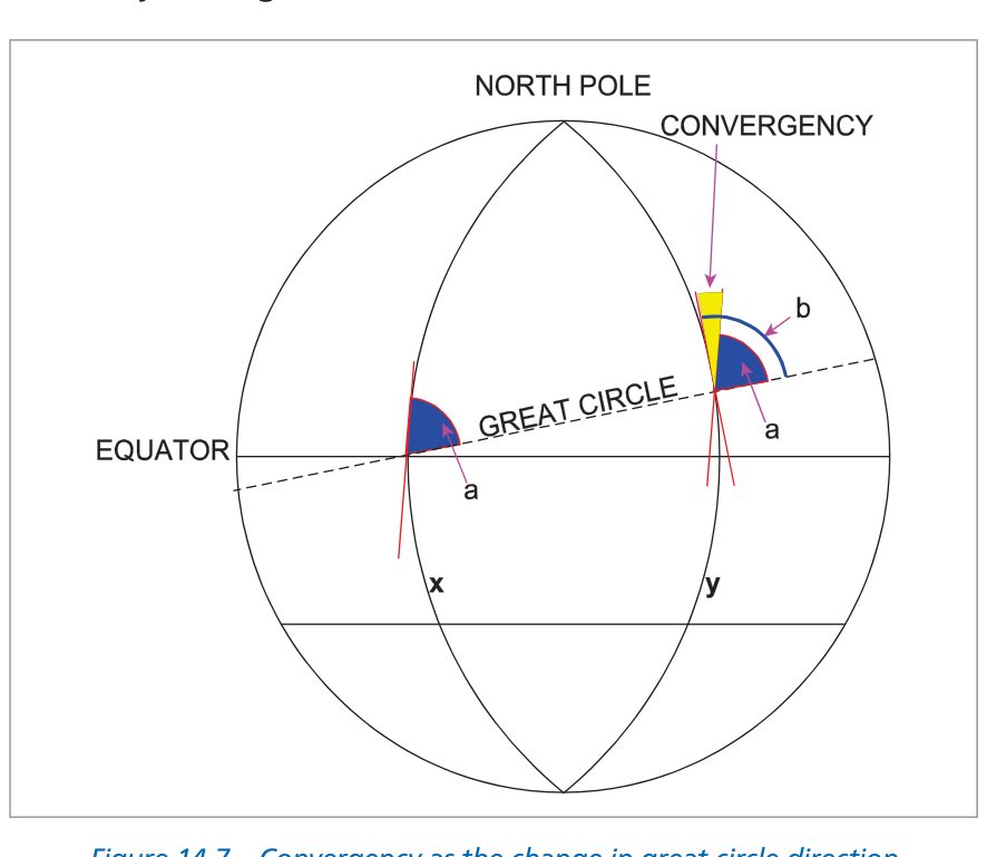
Figure 7 — A great circle cutting meridians X and Y — the angle 'a' at X and angle 'b' at Y differ by exactly the convergency between the meridians
Why a Rhumb Line Curves
A rhumb line (constant true track) appears as a straight line on a Mercator chart but as a curved line on a conformal conic chart. The reason is that to maintain a constant bearing from True North — and True North itself is rotating (because the meridians are converging) — the path must continuously curve. A rhumb line must compensate for meridian convergence in order to keep its track angle constant.
Conversely, a great circle — which is the shortest path between two points on the sphere — appears curved on a Mercator chart (curving toward the nearer pole) but as a straight line on a Lambert conformal chart (because the meridians themselves converge on that projection).
Key Relationship
The great circle track changes by the amount of convergency between its endpoints. If convergency = 8.5°, the GC track at arrival is 8.5° different from the GC track at departure — the D-I-I-D rule tells you in which direction.
The D-I-I-D Rule
When flying a great circle route, the track angle changes continuously. The D-I-I-D diagram tells you the direction of that change for any combination of hemisphere and direction of travel.
↑ Track INCREASES
↓ Track DECREASES
↓ Track DECREASES
↑ Track INCREASES
The mnemonic D-I-I-D stands for the four cells read clockwise from top-left: Decreases — Increases — Increases — Decreases (starting with SH going West = Increases, going around). More usefully, remember the two rules for the Northern Hemisphere (where most of our traffic is):
Northern Hemisphere Summary
Going East → Track INCREASES (e.g. 060° becomes 068.5° at destination)
Going West → Track DECREASES (e.g. 313° becomes 305° at departure point)
How to Apply the Rule
Step 1: Calculate convergency (ch.long × sin mid-lat).
Step 2: Look up D-I-I-D for your hemisphere and primary direction of travel.
Step 3: Add or subtract convergency from the departure track to get the arrival track.
Step 4: Take the reciprocal of the arrival track to get the initial track from B to A.
Alternative: Parallel Construction Line
Draw the initial track from A. Parallel it across to B (draw a line at the same angle to the vertical). The convergency angle is then visible as the angle between this parallel line and the meridian at B. Add the two angles to get the track at B; take the reciprocal for the reverse direction. Both methods give the same answer.
Worked Examples 1–3
Worked Example 1 — Initial GC Track Between Two Points
Given: Initial GC track from A (40°00′N 002°00′W) to B (50°00′N 010°00′E) is 060°(T). Find the initial GC track from B to A.
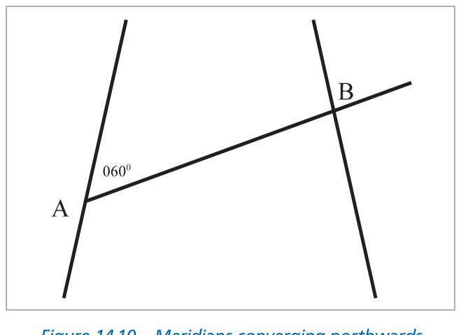
Figure 8 — Diagram for Example 1 — A is on the left (W) meridian, B on the right (E) meridian; initial track 060° from A toward NE
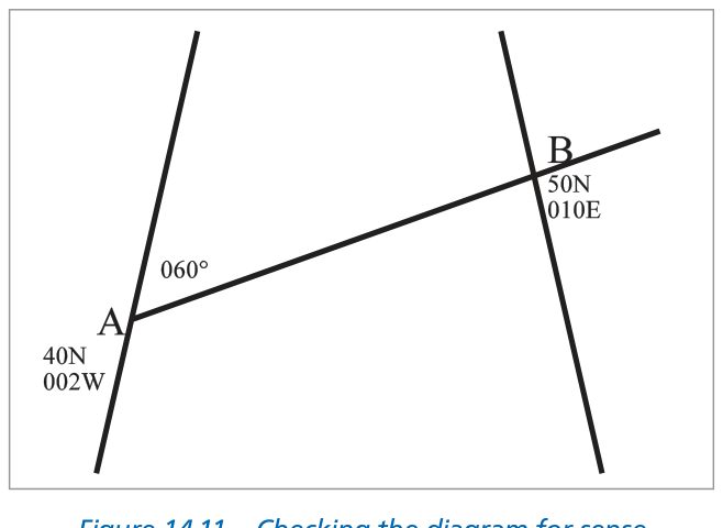
Figure 9 — Checking the diagram: B is north and east of A, confirmed by latitude/longitude comparison
Change of longitude = 002°W to 010°E = 12°
Mid-latitude = (40° + 50°) ÷ 2 = 45°N; sin 45° = 0.7071
Convergency = 12° × 0.7071 = 8.5°
Worked Example 2 — Finding an Unknown Longitude
Given: Initial GC track from C (36°00′N 015°00′E) to D (42°00′N) is 300°(T); final track at D is 295°(T). Find: (a) longitude of D; (b) GC track at 011°E.
Mid-latitude = (36° + 42°) ÷ 2 = 39°N; sin 39° = 0.629
Convergency = ch.long × sin(39°)
5° = ch.long × 0.629 → ch.long = 5° ÷ 0.629 = 8°
C is at 015°E and going west → D is at 015° − 8° = 007°E
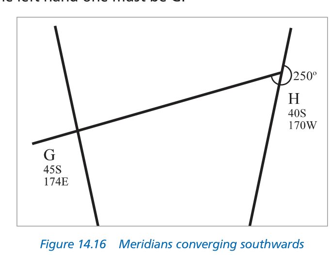
Figure 10 — Southern hemisphere meridians — meridians converge southward; for Q3 the setup reverses
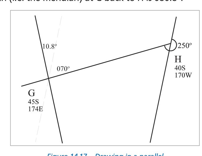
Figure 11 — Parallel construction: extend track from H, add convergency angle at G to find reciprocal
Worked Example 3 — Southern Hemisphere Route
Given: Initial GC track from H (40°00′S 170°00′W) to G (45°00′S 174°00′E) is 250°(T). Find initial GC track from G to H.
Mid-latitude = (40° + 45°) ÷ 2 = 42.5°S; sin 42.5° = 0.676
Convergency = 16° × 0.676 = 10.8°
Conversion Angle
Consider the situation in the diagram below. Two meridians are 40° of longitude apart. A rhumb line connects A (30°N 020°W) to B (30°N 020°E) along the parallel of latitude — this RL has a constant direction of 090°(T) throughout.
A great circle connecting the same two points does NOT follow the parallel. Because the GC is the shortest path between the points on the sphere, it arcs toward the nearer pole (northward in the Northern Hemisphere for an easterly track). At A, the GC heads off on a direction less than 090°(T) — it starts by heading slightly north of east. At B, it arrives on a direction greater than 090°(T) — it arrives heading slightly south of east. At the mid-longitude (000°E/W), the GC direction = the RL direction = 090°(T).
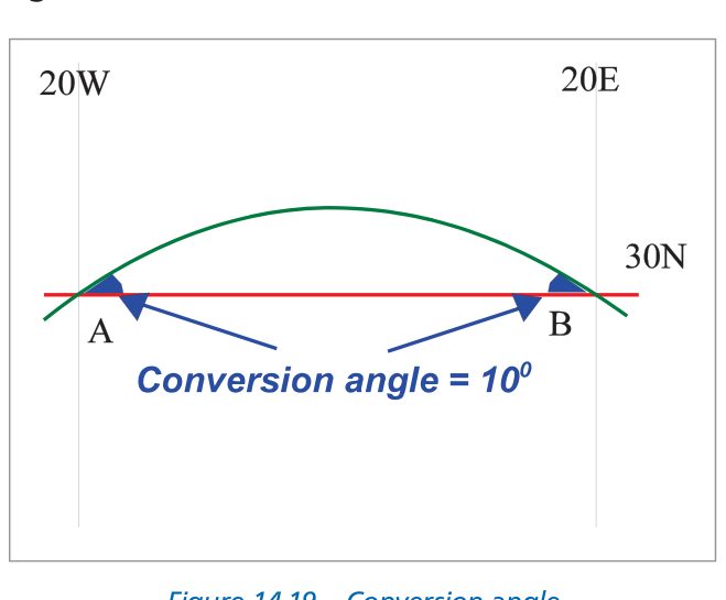
Figure 12 — Rhumb line (090° constant) vs great circle — RL shown as straight, GC bows toward the north pole between A and B
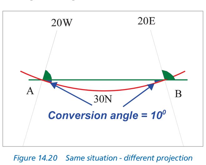
Figure 13 — Same geometry on a different projection — GC appears straight, RL curves; relative positions unchanged
Deriving Conversion Angle
In the example above:
- Convergency = 40° × sin(30°) = 40° × 0.5 = 20°
- The GC track changed 20° between A and B
- The RL track is 090° throughout and equals the GC at the midpoint
- So at A, GC = 090° − 10° = 080°(T)
- At B, GC = 090° + 10° = 100°(T)
- The difference between GC and RL at either endpoint = 10°
This difference — between the great circle direction and the rhumb line direction at a given point — is called the Conversion Angle (CA). In this case, CA = 10°.
Notice that CA is exactly half the convergency. This is always the case (for routes between two points at the same latitude; it is also used as an approximation for routes at slightly different latitudes).
Which Direction to Apply CA?
The GC always bows toward the nearer pole. Therefore:
- In the Northern Hemisphere, the GC arcs northward → at the departure point, GC is more northerly (smaller track number for E-bound; larger for W-bound) than the RL.
- In the Southern Hemisphere, the GC arcs southward → at the departure point, GC is more southerly than the RL.
Equivalently, at the departure point: RL = GC ± CA. Use the D-I-I-D/logical reasoning to determine the sign for your specific situation.
Radio Bearings and Conversion Angle
Radio waves travel along great circle paths over the surface of the Earth. When a VOR, NDB, or VDF station measures a bearing to or from an aircraft, that bearing is a great circle direction. For navigation plotting on a Mercator chart (where rhumb lines appear as straight lines), you must convert from great circle to rhumb line before plotting.
The Correction
Apply the Conversion Angle to the GC bearing to obtain the RL bearing:
Formula
RL bearing = GC bearing ± CA
The sign depends on which hemisphere and which direction (D-I-I-D logic)
Important: Apply CA at the Measurement Point
This is a critical, frequently examined point. If the GC bearing is measured at the aircraft, apply CA at the aircraft's position. If measured at the station, apply CA at the station's position. The CA correction is position-specific.
VOR Bearings
A VOR radial is a bearing measured from the station (QDR). It is a great circle direction. To plot a VOR radial on a Mercator chart, apply CA to convert to RL before plotting. On a Lambert chart, the correction is very small and often ignored for routine navigation.
NDB/ADF Bearings
An NDB bearing is measured at the aircraft. The ADF needle points along a great circle to the beacon. Apply CA at the aircraft's position to convert to a RL for Mercator plotting.
Practical Example
If the GC track from A to B is 100°(T) and CA = 4°, the RL track at A is found by: GC is 100°, which is slightly south of east in the NH. The RL (which is more 'direct', less curved) will be slightly closer to 090° → RL = 100° − 4° = 096°(T)… but check the exact geometry for your specific question (see Worked Example 6 below).
Worked Examples 4–6
Worked Example 4 — Convergency, RL Track, and GC from K to J
Given: J (58°12′N 004°00′W) and K (58°12′N 006°00′E). Both at same latitude.
Ch.long = 004°W to 006°E = 10°; Latitude = 58°12′N; sin 58.2° = 0.851
Convergency = 10° × 0.851 = 8.5°
Both points are at the same latitude (58°12′N). The RL connecting two points on the same parallel of latitude is the parallel itself — a constant direction of 090°(T) (due East).
Going West in NH → track DECREASES going west. The RL midpoint track = 090°.
GC at K (going west) = RL at midpoint − CA = 090° − 4.25° = 085.75°… but we want from K to J (opposite direction). RL from K to J = 270°(T). GC at K going west = 270° + CA = 274.25°
Or equivalently: reciprocal of GC from J to K at K = (090° − 4.25° = 085.75°) reversed → reciprocal = 265.75°? Let us use the formula directly:
Initial GC from K to J = 270° + CA = 270° + 4.25° = 274.25°(T) (GC bows northward, so at K going west it starts more northerly than 270° → larger number)
Worked Example 5 — INS Waypoint Changeover
Given: WP1 (53°N 030°W) → WP2 (53°N 020°W) → WP3 (53°N 010°W). An FMS/INS steers GC legs. What is the track change on passing WP2?
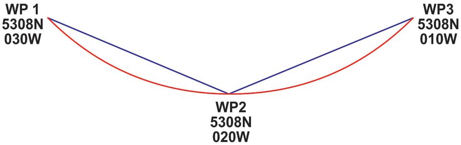
Figure 14 — INS waypoint changeover — WP1 to WP3 shows two consecutive GC legs at 53°N; a left turn occurs at WP2
CA per leg = ½ × 10° × 0.799 = 4.0°
GC leg 1 (WP1→WP2): departs WP1 on 086°, arrives WP2 on 094°
GC leg 2 (WP2→WP3): departs WP2 on 086°, arrives WP3 on 094°
Worked Example 6 — GC to RL Conversion at a Point
Given: A (55°N 000°E/W), B (54°N 010°E). Initial GC track from A to B is 100°(T). Find the RL track at A.
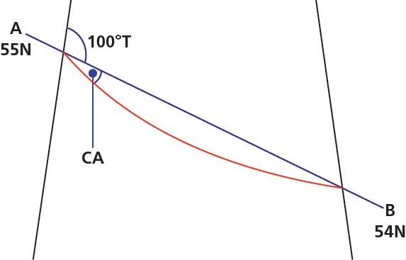
Figure 15 — Diagram for Example 6 — GC track 100°(T) at A; applying CA gives RL track 104°(T)
Ch.long = 10°; Mean latitude = (55° + 54°) ÷ 2 = 54.5°N; sin 54.5° = 0.814
CA = ½ × 10° × 0.814 = 4.07° ≈ 4°
⚠ Critical Point — Apply CA at the Measurement Position
The answer is 104°(T) because the GC bearing is measured AT A and we apply CA at A. If the GC bearing were given at B, we would apply CA at B's position instead. Never apply CA at the wrong endpoint.
Practice Questions
The following 10 questions are taken from the chapter. These are calculation-based questions — draw a diagram for each before calculating. Tap to reveal each answer.
Q1The convergency of the meridians through M and N (Southern hemisphere) is 12°. If the rhumb line track from M to N is 249°(T), what is the GC track: (a) from M to N? (b) from N to M?
SH going West → track INCREASES going west. GC is more southerly than RL at departure (bows toward S pole).
(a) GC from M→N at M: RL 249° is SW. GC more southerly = larger number. GC at M = 249° − 6° = 243°(T).
(b) GC at N (arrival from M) = 249° + 6° = 255°. Reciprocal = 255° − 180° = 075°(T).
Q2The GC bearing of position B (in latitude 30°00′S) from position A (30°00′S, 165°00′E) is 100°(T). What is (a) the GC track from B to A? (b) the longitude of B?
GC bearing from A to B = 100°(T). CA = GC − RL = 100° − 90° = 10°.
CA = ½ × ch.long × sin(30°) → 10° = ½ × ch.long × 0.5 → ch.long = 40°.
B is east of A at 165°E → longitude of B = 165° + 40° = 205°E = 155°W.
(a) GC at B going from B to A: arrive on 100° − reciprocal → GC from B = (100°+40°=140°)… Actually: GC at arrival at B = 100° − CA + CA = 80°(T) RL side; use track method: departure 100°, SH going east DECREASES → arrival = 100° − 20° (convergency) = 80°; reciprocal = 260°(T).
Q3The RL from D (30°00′N 179°00′W) to C is 090°(T). Initial GC from C to D is 287°(T). What is (a) the GC from D to C? (b) the approximate latitude and longitude of C?
GC from C to D = 287°(T). CA = |287° − 270°| = 17°. (RL from C to D = 270°; GC from C to D = 287°; difference = 17° = CA).
(a) GC from D to C at D: going east in NH → track increases. GC at D = 090° − CA = 073°(T) (more northerly than RL).
(b) CA = ½ × ch.long × sin(30°) → 17° = ½ × ch.long × 0.5 → ch.long = 68°. C is east of D: 179°W + 68°E = longitude 179° − 68° = 111°W. Position C = 30°N 111°W.
Q4The GC track from A to B measures 227°(T) at A and 225°(T) at B. What is the convergency and in which hemisphere?
Decrease going SW = going west component in NH (track decreases going W in NH) ✓
Convergency = |227° − 225°| = 2°. Northern Hemisphere.
Q5(a) At what latitude is the convergency between two meridians equal to twice their convergency at 20°N? (b) Is there a latitude where convergency = three times the value at 20°N?
Twice that = ch.long × 0.684. Need sin(lat) = 0.684 → lat = arcsin(0.684) ≈ 43°N.
Three times = ch.long × 1.026 → sin(lat) = 1.026 — impossible because sine cannot exceed 1.000. No such latitude exists.
Q6(a) A and B: GC from B to A = 268°(T), GC from A to B = 092°(T). i) Which hemisphere? ii) RL track from A to B? (b) C and D: GC from C to D = 063°(T), RL from D to C = 240°(T). i) Which hemisphere? ii) Initial GC from D to C?
Both A and B must share same latitude for RL = 090° (the difference between GC and RL is symmetrical). RL A→B = 090°(T).
(b): GC C→D = 063°(T) (NE direction). RL D→C = 240°(T) → RL C→D = 060°(T). CA = |063°−060°| = 3°. GC is more northerly (063°>060° in NE quadrant means less northerly actually... 063° vs 060°: 063° is MORE EASTERLY/LESS NORTHERLY. In SH, GC bows southward, so GC > RL for NE track. Confirms SH.
GC from D to C: RL = 240°. CA = 3°. In SH going SW (west component), track INCREASES. GC at D = RL + CA = 240° − 3° = 237°(T). (GC is more southerly = further from north = larger number for SW direction).
Answer: (b)i Southern Hemisphere; (b)ii GC D→C = 237°(T)
Q7Position X: 64°00′S 011°50′W. Position Y: 64°00′S 005°10′W. Give: (a) convergency between meridians of X and Y; (b) initial GC from Y to X; (c) RL track from X to Y.
Ch.long = 011°50′ − 005°10′ = 6°40′ = 6.67°. sin(64°) = 0.899.
(a) Convergency = 6.67° × 0.899 = 6.0° (rounded).
(b) RL from Y to X = 270°(T). CA = 3°. SH going west → track INCREASES. GC at Y = 270° − 3° = 267°(T).
(c) RL from X to Y = 090°(T).
Q8Position A: 55°30′N 004°35′W. Position B: 64°00′N 022°37′W. (a) Calculate convergency. (b) If RL track from A to B is 313°(T), what is the approximate initial GC track from B to A?
Convergency = 18.03° × 0.864 = 15.58° ≈ 15.5° (call it 16°)
(b) RL track A→B = 313°(T) (NW direction, going west in NH).
CA = 15.5/2 ≈ 7.75° ≈ 8°.
Going W in NH → track DECREASES. At A (departure): GC is more northerly than RL.
For NW track: 'more northerly' = closer to 360°/0° = larger track number (e.g. 320° is more northerly than 313°).
GC initial at A = RL + CA = 313° + 8° = 321°(T).
GC final at B (arrival) = 313° − 8° = 305°(T) [track decreased going west ✓].
GC from B to A = reciprocal of arrival track at B = 305° − 180° = 125°(T)
Q9The initial GC track from B to A is 245°(T) and the RL track from A to B is 060°(T). If mean latitude = 53°N and longitude of B = 002°15′E, what is the longitude of A?
CA = ½ × ch.long × sin(53°) → 5° = ½ × ch.long × 0.799 → ch.long = 12.5°.
B at 002°15′E, A is west of B (track A→B is 060° = NE, so B is NE of A, meaning A is SW of B, i.e. west). Longitude of A = 002°15′E + 12.5° west = 002°15′ + 12°30′ = 014°45′? Hmm — published answer is 010°15′W. ch.long = 002°15′E to 010°15′W = 012°30′. CA = ½ × 12.5° × 0.799 = 4.99° ≈ 5°. ✓ Longitude of A = 010°15′W.
Q10A and B are both in the Southern hemisphere and the convergency of their meridians is 8°. The initial GC track from A to B is 094°(T). B is at 23°00′S 020°00′W. What is position A?
RL = 090° means A and B are on the same latitude: 23°00′S.
Convergency = ch.long × sin(23°) = ch.long × 0.391 = 8° → ch.long = 20.46° ≈ 20°30′.
B is at 020°W. GC from A→B is 094° (easterly), so B is east of A. Longitude of A = 020°W + 20°30′ west = 040°30′W.
Position A = 23°00′S 040°30′W. (RL track A→B = 090°(T) ✓)
Quick Answer Key
Reinforce Chapter 8: Convergency and Conversion Angle
Test your knowledge and practice actual exam questions for Air Navigation.