Precipitation: Liquid water drops or solid water particles falling from clouds to the ground.
Type
Code
Size / Description
Drizzle
DZ
Very small size, Dia 0.2–0.5 mm
Rain
RA
Dia 0.5–5 mm
Shower
SH
Solid or liquid drops of Ice, Dia 0.5 mm
Hail
GR
Solid balls or pieces of ice (hailstones) with diameters 5–50 mm or more. 1 kg hail has also been reported.
Snow
SN
Assembly of ice crystals, wet or dry snow
Snow Grain
SG
Sleet is wet snow and ice pellets
Ice Pellets
PL
Small transparent ice particles, spherical/irregular, about less than 5 mm dia
Ice Crystals
IC
Also constitute precipitation
Mnemonic for precipitation codes:DR SH GR SN SG PL IC = Drizzle Rain SHower (raiN) GRaupel/Hail SNow SG (snow grain) PL (ice pellets) IC (ice crystals)
2. Theories of Precipitation Formation
For precipitation to occur, cloud particles must grow large enough to overcome vertical currents inside the clouds. The exact process is not yet fully known. Three theories:
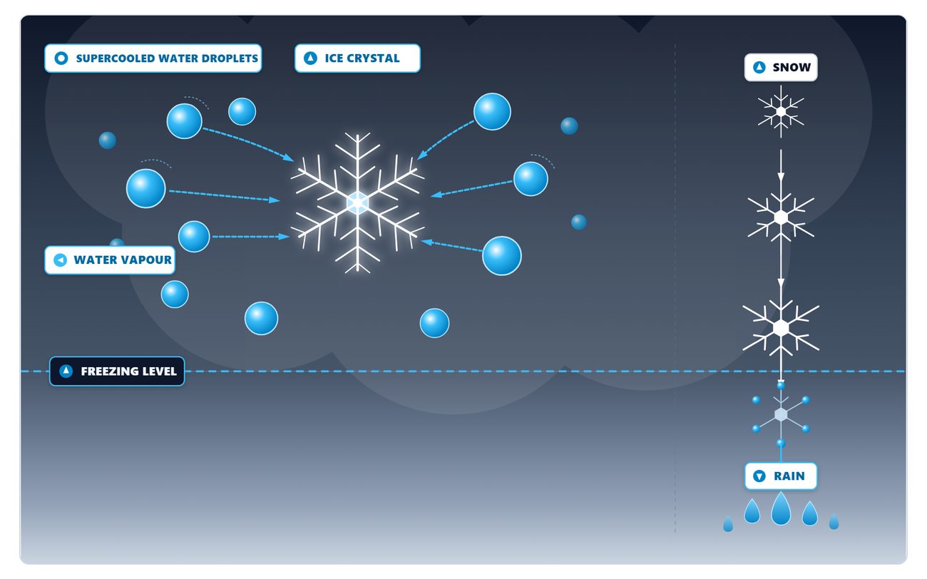
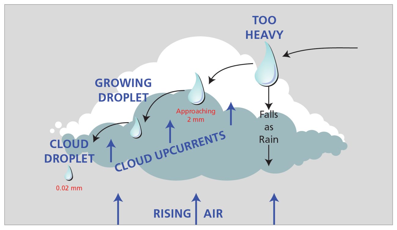
Ice crystals grow at the expense of supercooled dropletsHow a raindrop grows
Bergeron Ice Crystal Theory (Cold Cloud Process)
In Cold clouds (tops extend well above freezing level), super cooled water and ice particles co-exist. Saturation vapour pressure is more over water drops than over ice crystals → water drops evaporate and sublimate (direct conversion to ice without going through liquid phase) over the ice crystals → ice crystals grow at expense of water drops → while falling, bigger ice crystals encounter supercooled water drops which continually freeze onto them → ice crystals grow to large sizes and fall out of cloud base as snow or rain.
Coalescence Theory (Warm Cloud Process)
The above Bergeron theory is unable to explain rainfall from Warm clouds (do not reach freezing level). In tropical areas, showers occur from clouds which do not extend much above the freezing level and sometimes not even up to the freezing level. The coalescence theory: large drops initially form by collision and coalescence of the smaller droplets in the cloud. Coalescence increases markedly due to vertical currents → drops become larger → as large drops fall, pressure falls in their wake → smaller drops sucked in and get attached to falling drops → during fall a large drop collides with the smaller drops on its path and also get attached. Ultimately number of large drops form.
Giant Nucleus Theory
In maritime areas, clouds with lesser vertical development can give rain due to presence of large number of salt particles from salt spray. These giant hygroscopic nuclei are carried up to the cloud in vertical currents. They absorb water vapour and form large water drops and initiate the chain reaction of coalescence.
flowchart TD
    A[Precipitation Formation] --> B[Cold Cloud\nBergeron Theory]
    A --> C[Warm Cloud\nCoalescence Theory]
    A --> D[Maritime\nGiant Nucleus Theory]
    B --> E[Ice crystals grow\nat expense of water drops\n→ fall as snow/rain]
    C --> F[Large drops form by\ncollision and coalescence\n→ rain without reaching 0°C]
    D --> G[Salt nuclei absorb WV\n→ large drops\n→ coalescence chain]
3. Cloud Types and Precipitation
Type of Cloud
Precipitation Type
Stratus (ST)
Drizzle
Altostratus (AS)
Rain and Snow
Nimbostratus (NS)
Continuous precipitation (rain/snow)
Towering Cumulus (TCU) and Cumulonimbus (CB)
Rain, Showers, Hail and Snow
Cumulus (CU) of slight vertical development (fair weather), Altocumulus (AC) and high clouds (CI, CC)
No precipitation
Thick Cirrostratus (CS)
Snow at high to medium levels
Quick Cloud-Precip Table:
ST → Drizzle | AS → Rain + Snow | NS → Continuous | CB/TCU → RA SH GR SN | CS → Snow (high level) | CU (fair wx)/AC/CI/CC → None
4. Snow and Sleet
Snow and Sleet Conditions:
When surface temperature is less than about 4°C AND mean temperature between the base of cloud and the surface level is less than 0°C → precipitation may be in the form of snow or sleet. Snowfall is usually in the form of flakes = mixtures of various shapes of minute ice-crystals. Sleet = mixture of rain and snow.
5. Cloud Burst and Flash Floods
Cloud Burst: Very heavy showers or rain over an area in a short period. A sudden rise in the level of rivers or streams causing floods is called Flash Floods.
Aviation Warning: Cloud burst associated with intense CB activity. Flash floods may affect low-lying aerodromes and approach paths. Extreme downdrafts and microbursts associated with intense convective systems.
6. Rainy Day
Rainy Day: When the rainfall amount in a day is 2.5 mm or more, it is called a Rainy Day. Terms used to describe spatial distribution of rainfall are at Appendix D.
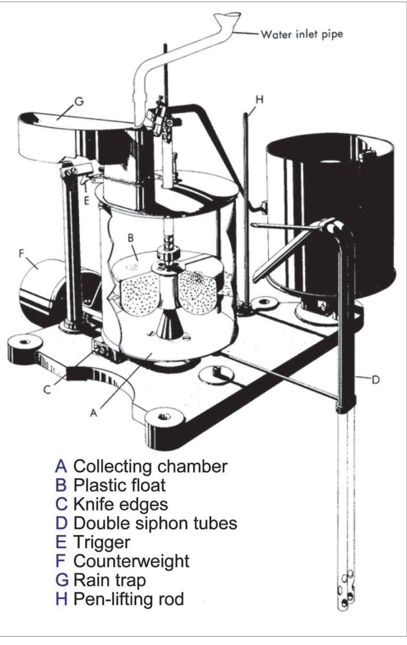
Rainfall recorder
7. Diurnal and Seasonal Variation of Rainfall
Tropical Regions
In the tropics, clouds form mainly due to convection, most vigorous in the afternoon. Precipitation most common in the afternoons. In coastal areas (sea breeze effect) and in valleys/NE India (due to Katabatic/Anabatic effect), maximum rain occurs at night or during early morning hours, elsewhere mostly in afternoon and early night.
Temperate Latitudes
Clouds form due to convergence caused by depressions or fronts, frequent in winters. Therefore, rain or snow is maximum in winters. India partially follows this pattern — WDs (which are occluded fronts) give high precipitation in winters.
Seasonal Pattern in India
Region/Effect
Maximum Rainfall Time
Tropics (convection)
Afternoons
Coastal areas (sea breeze)
Night or early morning
NE India (Katabatic/Anabatic)
Night or early morning
J&K and Western Himalayas
Winter (due to WDs)
Temperate latitudes
Winters (frontal systems)
Post-monsoon/coastal India
After summer
8. Artificial Rain Making / Cloud Seeding
Cloud Seeding: An attempt to stimulate precipitation by injecting nucleating agents into the clouds: silver iodide, common salt, solid carbon dioxide etc. Spraying of Potassium Chloride in small clouds has shown encouraging results — either clouds grow rapidly or cause rain in 15–20 minutes.
The particles sprayed act like ice forming nuclei to initiate Bergeron process. Mixture of potassium chloride and sodium chloride act the same way. However, the rain so created may deprive some other area of rainfall where it would have occurred naturally.
Uses of Cloud Seeding
Fighting fires
Ending drought
Promoting harvests
Draining clouds
Fog dispersal — Fog can also be cleared for a short period either by increasing air temperature or by seeding the fog as above, especially to enable aircraft to land and take off
Q: Is artificial rain making (cloud seeding) also termed as Simulation? Yes — it is also termed as Simulation, Cloud Seeding, or Nucleation. Textbook Q16 answer = (c) Nucleation.
9. Classification of Rainfall
Classification
Rainfall (mm/day)
Light
< 7.5 mm
Moderate
7–35.5 mm
Rather Heavy
35.6–64 mm
Heavy
64.5–115.5 mm
Very Heavy
115.6–204.4 mm
Extremely Heavy
≥ 204.5 mm
Fog Dispersal by Cloud Seeding: Fog can be dispersed for a short period either by increasing air temperature or by seeding the fog above — especially to enable aircraft to land and take off.
10. Practice Q&A
Q1. When super cooled water drops and ice particles co-exist, the ice crystals grow at the expense of the water drops because (a) Saturation vapour pressure over ice crystals is less than over water drops (b) Saturation vapour pressure over the ice crystals is less than over the water drops (c) The ice crystals convert into water drops
✅ Answer: (a) Saturation vapour pressure over ice crystals is less than over water drops
SVP over water > SVP over ice. Water evaporates (higher SVP) and ice crystals grow by sublimation (absorbing WV). This is the basis of the Bergeron Ice Crystal Theory.
🎯 SVP water > SVP ice → water evaporates → ice grows. Key to Bergeron theory.
Q2. The clouds whose tops extend to the freezing level are called (a) Warm Clouds (b) Cold Clouds (c) Moderate Clouds
✅ Answer: (b) Cold Clouds
Cold clouds have tops extending well above the freezing level — super cooled water and ice co-exist. Warm clouds do not reach the freezing level.
Warm clouds = tropical clouds with tops below freezing → only coalescence theory applies.
Q3. The clouds whose tops do not extend to the freezing level are called (a) Warm Clouds (b) Cold Clouds (c) Moderate Clouds
✅ Answer: (a) Warm Clouds
Warm clouds don't reach freezing level. Rain explained by Coalescence theory — large drops by collision of droplets.
🎯 Warm cloud = no ice = coalescence only. Common in tropics/maritime areas.
Q4. Coalescence Theory explains occurrence of rainfall from (a) Warm Clouds (b) Cold Clouds (c) Both types of Clouds
✅ Answer: (a) Warm Clouds
Coalescence theory was advanced specifically to explain rainfall from warm clouds (below freezing level) in tropical areas where Bergeron theory fails.
Q5. Ice crystal Theory explains occurrence of rainfall from (a) Warm Clouds (b) Cold Clouds (c) Both types of Clouds
✅ Answer: (b) Cold Clouds
Bergeron Ice Crystal Theory (cold cloud process) applies to clouds with tops above the freezing level where ice and supercooled water co-exist.
🎯 Ice Crystal = Cold Cloud. Bergeron / Cold Process = the same thing.
Q6. Giant Nucleus Theory explains occurrence of rainfall over (a) Maritime areas (b) Inland areas (c) Hilly areas
✅ Answer: (a) Maritime areas
Giant Nucleus Theory applies to maritime (ocean/coastal) areas where sea salt provides large hygroscopic nuclei that initiate coalescence even in clouds with lesser vertical development.
🎯 Giant Nucleus = Salt from sea = Maritime. Explains coastal rain from relatively small clouds.
Q7. Very heavy precipitation as showers over an area above the mountain range is called (a) Maritime areas (b) Inland areas (c) Orographic Rain
✅ Answer: (c) Orographic Rain
Rain caused by air being forced up a mountain range is orographic rain: the windward slope gets the heavy rain and the lee side is drier.
💡 Orographic = mountain-caused rain.
Q8. Rain shadow area is on the ......... of the mountain range (a) Top (b) Windward side (c) Leeward side
✅ Answer: (c) Leeward side
The leeward (downwind) side of a mountain range receives much less rainfall — called the rain shadow area. Air descends on leeward → warms → dries out.
Q11. Rainfall in the tropics is more in the (a) Morning (b) Afternoon (c) Night
✅ Answer: (b) Afternoon
Thermal convection peaks in afternoon in tropics → maximum cloud development → maximum rainfall in afternoon. (Coastal areas: night/early morning due to sea breeze circulation.)
Q13. Over J&K and western Himalayas Rainfall is more in (a) Winters (b) Summers (c) Post monsoon
✅ Answer: (a) Winters
J&K and western Himalayas get maximum rainfall in winters due to Western Disturbances (WDs) — which are occluded frontal systems from the Mediterranean region.
🎯 J&K + Winters + WDs = important for Indian pilots. WDs bring western Himalayan snowfall/rain.
Q14. Rainfall over coastal areas is more in (a) Evening (b) Night & early morning (c) Afternoon
✅ Answer: (b) Night & early morning
At coastal areas, sea breeze creates offshore convergence at night/early morning → maximum rain at night/early morning. During day, sea breeze pushes clouds inland.
🎯 Coastal areas: max rain at night/early morning due to sea breeze circulation reversal.
Q15. Areas to the ......... of Western Ghats of India are rain shadow areas (a) W (b) S (c) E
✅ Answer: (c) E
Western Ghats force SW monsoon air upward on the western (windward) slopes → heavy rainfall. Eastern side = leeward = rain shadow (Deccan Plateau is drier).
🎯 Western Ghats: West = heavy rain (windward). East = rain shadow. Classic Indian exam question.
Q16. A sudden rise in the level of rivers or streams causing floods is called (a) Cloud Burst (b) Catchments flooding (c) Flash Floods
✅ Answer: (c) Flash Floods
Cloud Burst = very heavy rain in short period. Flash Floods = sudden rise in river/stream levels caused by cloud burst.
🎯 Cloud Burst → causes → Flash Floods. Different terms for related phenomena.
Q17. Artificial rain making is also termed as (a) Simulation (b) Cloud seeding (c) Nucleation
✅ Answer: (b) Cloud seeding
Artificial rain-making is called cloud seeding: freezing nuclei such as silver iodide, or dry ice, are introduced into a cloud to start the Bergeron process.
Q18. Fog can also be dispersed for a short period by artificial stimulation (a) True (b) False
✅ Answer: (a) True
Cloud seeding techniques can disperse fog temporarily, either by heating or seeding — to enable aircraft to land and take off. This is used at some airports for CAT III operations improvement.
🎯 FIDO (Fog Investigation and Dispersal Operation) is a real-world application of fog dispersal.
Q19. Showery precipitation occurs from (a) NS (b) AC (c) CB
✅ Answer: (c) CB
Showers (SH) = intermittent, heavy precipitation from CB. NS gives continuous rain, not showers. AC generally gives no precipitation.
🎯 SHowers = CB. Continuous = NS. Drizzle = ST.
Q20. A day is called Rainy day when rainfall in 24 hr is ......... mm or more (a) 1.5 (b) 2 (c) 2.5
✅ Answer: (c) 2.5
A Rainy Day = rainfall ≥ 2.5 mm in 24 hours. This is the standard meteorological definition used in India.
🎯 Rainy Day threshold = 2.5 mm/day. DGCA exam staple.