Part I (ix) Meteorological codes, Pre-Flight briefing service and their usages
Learning objectives — by the end of this chapter you will be able to…
- Explain why aviation weather is coded and read a METAR/SPECI field by field.
- Interpret a TAF, its validity and change groups, and the TREND group.
- Identify SIGMET, AIRMET, PIREP and GAMET, and the ATIS/VOLMET broadcasts.
- State the CAVOK criteria and decode the cloud, weather and RVR groups.
- Describe the pre-flight briefing service and the pilot's information sequence to a go/no-go decision.
6.1 Why weather is coded
6.2 METAR & SPECI — field by field
6.3 Cloud, weather & RVR groups
6.4 TAF — the aerodrome forecast
6.5 TREND, SIGMET, AIRMET, PIREP
6.6 ATIS & VOLMET
6.7 CAVOK
6.8 The pre-flight briefing service

6.1 Why weather is coded
Weather decisions are made by crews of every nationality, and the information often crosses a noisy radio or telex link. A free-text English forecast would be slow, ambiguous and easy to garble. So the world adopted a fixed-order, internationally standardised code: every report follows the same sequence of groups, so a pilot in Mumbai or Madrid reads it identically and a single transposed letter is obvious. Master the order of the slots and any report decodes itself.
Reports describe weather that is happening: METAR (routine, observed) and SPECI (special, off-schedule observation).
Forecasts describe weather that will happen: TAF (aerodrome forecast) and the appended TREND (a 2-hour landing forecast).
6.2 METAR & SPECI — field by field
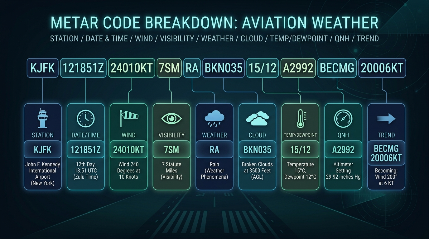
A METAR is the routine observed weather at an aerodrome, issued at fixed intervals (commonly every 30 or 60 minutes). A SPECI uses the same format but is issued off-schedule when something changes significantly. Both follow the same fixed order.
| VABB 241230Z 27008KT 8000 -RA FEW020 SCT025 BKN090 32/26 Q1008 NOSIG | |
| VABB | Mumbai — station (ICAO indicator) |
| 241230Z | 24th day of month, 1230 UTC (Zulu) |
| 27008KT | wind 270° (TRUE) at 8 knots |
| 8000 | visibility 8000 metres |
| -RA | light rain (− light, + heavy) |
| FEW020 SCT025 BKN090 | few cloud at 2000 ft; scattered 2500 ft; broken 9000 ft |
| 32/26 | temperature 32 °C / dewpoint 26 °C |
| Q1008 | QNH 1008 hPa (an "A2992" would be inches of mercury) |
| NOSIG | trend: no significant change expected |
"Station, Time, Wind, Visibility, Weather, Cloud, Temp/Dewpoint, Pressure, Trend." Always the same slots — once you know them, any METAR decodes itself.
Wind in a METAR/TAF is in degrees TRUE and knots; the surface wind passed by ATC on the radio is in degrees MAGNETIC. Same wind, different reference — a favourite catch. A gust is shown as e.g. 27015G27KT; a variable direction as VRB.
From the METAR above: lowest broken (operational ceiling) is BKN090 = 9000 ft; visibility 8000 m; light rain; temp/dewpoint 32/26 — a 6 °C spread, so humid but not yet fog.
Why temp/dewpoint matters: when the dewpoint closes on the temperature, the air is near saturation and fog/low cloud becomes likely. A 1–2 °C spread on a cooling evening is a warning sign for the destination.
6.3 Cloud, weather & RVR groups
FEW 1–2 oktas · SCT (scattered) 3–4 · BKN (broken) 5–7 · OVC (overcast) 8. Heights are in hundreds of feet above aerodrome (020 = 2000 ft). NSC = nil significant cloud; SKC/NCD = sky clear / no cloud detected.
| Group | Meaning | Group | Meaning |
|---|---|---|---|
| RA / SN | Rain / Snow | FG / BR | Fog / Mist |
| TS / SH | Thunderstorm / Shower | DZ / GR | Drizzle / Hail |
| CB / TCU | Cumulonimbus / Towering cumulus | HZ / FU | Haze / Smoke |
| + / − | Heavy / Light prefix | VC | In the vicinity |
When visibility is low, an RVR group appears, e.g. R27/0600 = runway 27, RVR 600 m. Runway Visual Range is the distance over which a pilot on the centreline can see the runway markings or lights — measured by transmissometers, and the governing visibility for low-visibility approaches (full RT detail in Chapter 21).
6.4 TAF — the aerodrome forecast
A TAF is the forecast for an aerodrome over a validity period, written in the same vocabulary as a METAR but with change groups that say "and then it will become…". A TAF begins with its issue time and the validity period (e.g. 2412/2512 = from the 24th 1200Z to the 25th 1200Z).
| Group | Meaning |
|---|---|
| FM (FROM) | A rapid, permanent change from the stated time onward |
| BECMG | A gradual (becoming) change over the stated period |
| TEMPO | Temporary fluctuations, each lasting under an hour, totalling less than half the period |
| PROB30 / PROB40 | 30% / 40% probability of the stated conditions |
6.5 TREND, SIGMET, AIRMET & PIREP
| Code | What it is |
|---|---|
| TREND | A 2-hour landing forecast appended to a METAR (NOSIG / BECMG / TEMPO) |
| SIGMET | Warning of weather significant to all aircraft — thunderstorms, severe turbulence/icing, volcanic ash, tropical cyclones, dust/sandstorms |
| AIRMET | Warning of weather significant to low-level / lighter aircraft operations |
| PIREP | A pilot report of conditions actually encountered in flight |
| GAMET | An area forecast for low-level flights |
SIGMET = SIGnificant to all; AIRMET = lighter AIRcraft. Both are warnings; PIREP is what a pilot actually saw.
6.6 ATIS & VOLMET
ATIS — Automatic Terminal Information Service: a continuous broadcast of one aerodrome's weather, runway-in-use and operational information, identified by a letter (Information "Alpha", "Bravo"…), so the frequency isn't tied up reading it to every aircraft.
VOLMET — a scheduled broadcast of en-route meteorological information (METARs/TAFs/SIGMETs) for several aerodromes, for aircraft in flight, on HF and/or VHF.
You listen to ATIS before first contact and read back the letter ("…with Information Charlie") so the controller knows you have the current weather and runway. It saves a congested frequency from reading the same numbers a hundred times an hour — and confirms you and ATC share the same picture.
6.7 CAVOK
Used when all of these hold simultaneously: visibility 10 km or more; no cloud below 5000 ft (or below the highest minimum sector altitude, whichever is greater) and no CB or TCU at any level; and no significant weather at or near the aerodrome. When CAVOK applies, the visibility, cloud and weather groups are replaced by the single word.
CAVOK is not just "nice weather" — it has the three defined criteria above. A common wrong answer is "visibility 8 km"; the threshold is 10 km. And a single CB, even with great visibility, disqualifies CAVOK.
6.8 The pre-flight briefing service
Before a flight a pilot must gather the weather and the NOTAMs, study the procedures, and file a flight plan. The service that makes this possible is the pre-flight briefing service, run by the Aeronautical Information Service at the aerodrome, increasingly through self-briefing terminals and online portals.
At the AIS/briefing office (or via self-briefing terminals / the online flight-planning portal) a pilot obtains: the relevant METARs and TAFs; SIGMET/AIRMET/GAMET warnings; the route NOTAMs packaged as a PIB (Pre-flight Information Bulletin); charts and AIP data; and the means to file the ATS flight plan.
1. Obtain the weather — METAR/TAF for departure, destination and alternates; SIGMETs en route.
2. Obtain the PIB — NOTAMs affecting the route and aerodromes.
3. Study the AIP/charts for procedures, facilities and frequencies.
4. File the flight plan with ATS.
5. Make the go / no-go decision against the operating minima and fuel.
☆ Numbers to memorise
| Fact | Value |
|---|---|
| METAR / SPECI | Routine / special observed aerodrome report |
| METAR order | Station · Time(Z) · Wind · Vis · Weather · Cloud · Temp/Dew · QNH · Trend |
| Wind reference | METAR = degrees TRUE; ATC surface wind = degrees MAGNETIC |
| Cloud amounts | FEW 1–2 · SCT 3–4 · BKN 5–7 · OVC 8 oktas (hundreds of ft) |
| TAF change groups | FM · BECMG · TEMPO · PROB30/40 |
| CAVOK | Vis ≥10 km · no cloud <5000 ft / no CB·TCU · no significant wx |
| SIGMET / AIRMET | Hazard to all aircraft / to low-level light aircraft |
| ATIS / VOLMET | One-aerodrome broadcast / en-route multi-aerodrome broadcast |
| PIB | Pre-flight Information Bulletin (route NOTAM digest) |
Part A — MCQs (click an option to check)
Part B — Oral / viva (tap to reveal model answers)
60-SECOND REVISION CARD
- METAR observed, SPECI special, TAF forecast (FM/BECMG/TEMPO/PROB). Order: Station·Time·Wind·Vis·Wx·Cloud·T/Dew·QNH·Trend.
- Wind: METAR TRUE/kt vs ATC MAGNETIC. Cloud FEW 1–2 · SCT 3–4 · BKN 5–7 · OVC 8.
- CAVOK = vis ≥10 km, no cloud <5000 ft / no CB·TCU, no significant wx (one CB disqualifies).
- SIGMET all aircraft · AIRMET light · PIREP pilot-seen · ATIS one field · VOLMET en-route.
- Briefing = weather + PIB (NOTAMs) + charts + file flight plan → go/no-go.