Part I (ii) General & Aeronautical 'Q' Code signals and other abbreviations (ICAO Annex 10, Vol I & II)
Learning objectives — by the end of this chapter you will be able to…
- Explain what a Q-code is, where it came from, and why aviation keeps a few.
- Define and apply QNH, QFE, QNE and QFF, and explain the altimetry behind each.
- Explain transition altitude/level and when each pressure setting is used.
- Distinguish the bearing codes QDM, QDR, QTE, QUJ (and QGH) and solve bearing problems.
- Recall common operational Q-codes and standard abbreviations.
- State precisely the definitions of altitude, height, elevation and flight level.
4.1 What a Q-code is
4.2 The pressure-altimeter — how it works
4.3 QNH, QFE, QNE & QFF
4.4 Transition altitude & level
4.5 The bearing Q-codes
4.6 Working bearing problems
4.7 Other operational Q-codes
4.8 Standard abbreviations
4.9 Altitude · height · elevation · flight level
4.1 What a Q-code is
Q-codes were invented for Morse telegraphy, where every character costs time. A three-letter group beginning with Q was agreed to stand for a complete phrase, so a long sentence could be sent as three letters. Cleverly, the same code can be a question or its answer depending on context: "QFE?" asks the field pressure; "QFE 1004" answers it. Voice radio later made full sentences cheap, so most Q-codes faded — but a handful proved so compact and unambiguous (and impossible to mishear as ordinary words) that aviation kept them: above all the pressure settings and a few bearings.
A standardised three-letter code, each group beginning with Q, representing a fixed phrase, listed in ICAO documentation (Annex 10 and related). It is international and language-independent, and may be used as a question or an answer.

4.2 The pressure-altimeter — how it works
Atmospheric pressure falls with height — roughly 1 hPa per 27–30 ft near sea level. A pressure altimeter is simply an aneroid barometer with its scale marked in feet: it measures the outside static pressure and displays the corresponding altitude. But "the corresponding altitude" depends entirely on what pressure you call the datum. The subscale (Kollsman window) lets the pilot set that datum. Setting a different datum slides the whole scale up or down — which is exactly what the pressure Q-codes select.
4.3 QNH, QFE, QNE & QFF
| Code | What you set on the subscale | Altimeter then reads |
|---|---|---|
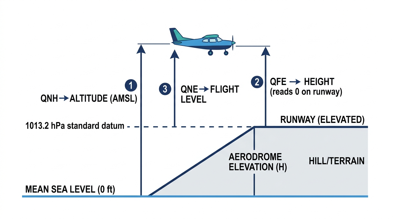
| QNH | Pressure reduced to mean sea level for the area | Altitude above mean sea level — and the aerodrome elevation when on the ground |
| QFE | The actual pressure at the aerodrome / runway datum | Height above that datum — zero on the runway |
| QNE | The standard setting 1013.2 hPa (29.92 inHg) | Pressure altitude / flight level |
| QFF | The true mean-sea-level pressure (meteorological) | Used by met services; not normally set for flying |
≈ 1 hPa = 27 ft near sea level (often rounded to 30 ft). So a 1 hPa error in the subscale setting puts the altimeter out by ≈ 27 ft; a 10 hPa error ≈ 270 ft. Always set the correct datum — this small number is why a wrong setting is so dangerous near the ground.
QNH is 1013 hPa but you mistakenly set 993 hPa (20 hPa low).
Error ≈ 20 hPa × 27 ft = 540 ft. With the lower pressure set, the altimeter over-reads — it shows you higher than you are, so you are actually ~540 ft lower than indicated. On an approach in cloud, that is the difference between clearing terrain and not.
Memory aid: "High to Low, look out below." Flying from high pressure to low (or setting too low a value) makes you lower than indicated.
QFE = Field Elevation → reads zero on the Field. QNH = Nautical Height → reads height above the sea (altitude AMSL). QNE = Normal/National standard → the fixed 1013 setting for flight levels.
"Altitude" vs "height" is the catch. QNH → altitude (above sea level). QFE → height (above the airfield). Naming the right code but the wrong word loses the mark. And QNE is a fixed value (1013.2), not a number passed by ATC.
🔍 Deep dive — QNH vs QFF
Both reduce pressure to sea level, but differently. QNH uses the ISA (standard atmosphere) relationship, so on the ground the altimeter reads the aerodrome's surveyed elevation. QFF uses the actual temperature/conditions to give the true MSL pressure — more accurate meteorologically, but it would not make the altimeter read field elevation. For flying you use QNH; QFF appears on weather charts.
4.4 Transition altitude & level
Low down, near terrain, everyone wants altitude above the actual sea-level pressure (QNH). High up, for traffic separation, everyone wants a common datum so two aircraft's altimeters agree — so all switch to the standard 1013.2 (QNE) and call levels "flight levels". The switch happens at a defined boundary.
Transition Altitude — the altitude at or below which vertical position is expressed as altitude on QNH. Transition Level — the lowest flight level (on 1013.2) available above the transition altitude. Transition Layer — the airspace between the two. Climbing: set 1013 (QNE) passing the transition altitude. Descending: set QNH passing the transition level.
Climb → Standard at the Altitude; Descend → QNH at the Level. Going up you reach the altitude first; coming down you reach the level first.
4.5 The bearing Q-codes
These four answer "which way?" relative to a station. Two are magnetic (QDM, QDR), two are true (QUJ, QTE); two point to the station, two point from it.
| Code | Meaning | Reference |
|---|---|---|
| QDM | Magnetic heading to steer (zero wind) to reach the station | Magnetic · TO |
| QDR | Magnetic bearing from the station (the radial) | Magnetic · FROM |
| QUJ | True bearing to the station | True · TO |
| QTE | True bearing from the station | True · FROM |
QDR = QDM ± 180° (the bearing from is the reciprocal of the heading to). Likewise QTE = QUJ ± 180°. And magnetic ↔ true differs by the local variation: True = Magnetic ± Variation (East least, West most → "Variation East, magnetic least").
QDM = Direction to Mother — the magnetic heading home to the station. Its reciprocal QDR goes away. Letter cue: the Magnetic pair share "QD" (QDM/QDR); the True pair are QUJ/QTE.
🔍 Deep dive — QGH, QGE & other navigation Q-codes
QGH is a controlled descent through cloud flown on bearings given by a ground direction-finding (DF) station — an older "let-down by bearings" before ILS. You may also meet QGE (distance/height from a station), QTF (a position fix from two or more DF bearings), and QDL (a series of bearings). These are rarely flown today but appear as recognition questions; know QGH = controlled descent / DF let-down.
4.6 Working bearing problems
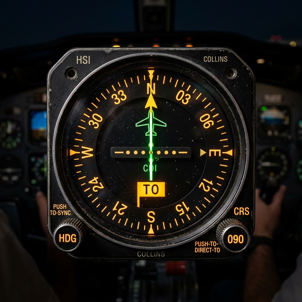
An ADF gives QDM 090° to an NDB.
QDR (radial you are on) = 090 ± 180 = 270°.
So you are on the 270° radial (west of the station) and would steer 090° in nil wind to reach it.
QDM is 090° and the local magnetic variation is 5° West.
True bearing to the station (QUJ): with West variation, True = Magnetic − Variation = 090 − 5 = 085°.
QTE (true from) = 085 ± 180 = 265°. ("Variation West, magnetic best" — the magnetic figure is the larger.)
4.7 Other operational Q-codes
| Code | Meaning |
|---|---|
| QSY | Change frequency (to …) |
| QAM | The latest meteorological report (for …) |
| QFE / QNH / QNE | Pressure settings (see 4.3) |
| QDM / QDR / QUJ / QTE | Bearings (see 4.5) |
| QGH | Controlled descent through cloud (DF let-down) |
| QTF | Position (fix) from DF bearings |
4.8 Standard abbreviations you must read on sight
| Abbr. | Meaning | Abbr. | Meaning |
|---|---|---|---|
| UTC | Coordinated Universal Time ("Zulu") | AMSL/AGL | Above Mean Sea Level / Above Ground Level |
| ATIS | Automatic Terminal Information Service | VOLMET | En-route met broadcast |
| METAR/TAF | Weather report / aerodrome forecast | RVR | Runway Visual Range |
| CAVOK | Ceiling and visibility OK (defined) | WILCO | Will comply |
| ROGER | Received all your last transmission | SELCAL | Selective Calling (tone alert) |
| ETA/ETD | Estimated Time of Arrival / Departure | QDM | Magnetic heading to a station |
4.9 Altitude · height · elevation · flight level
Altitude — the vertical distance of a level, point or object measured from mean sea level (read on QNH).
Height — the vertical distance of a level, point or object measured from a specified datum, e.g. the aerodrome (read on QFE).
Elevation — the vertical distance of a point on or affixed to the surface above mean sea level.
Flight Level (FL) — a surface of constant atmospheric pressure related to the standard datum 1013.2 hPa (read on QNE); e.g. FL100 = 10,000 ft pressure altitude.
On departure you fly on QNH reading altitude; passing the transition altitude you wind the subscale to 1013 (QNE) and read flight levels; arriving at a small field you might use QFE so the altimeter reads height above the runway. Three codes, three readings — set the wrong one and your "1,000 ft" may be 1,000 ft lower than you think (recall 4.2).
☆ Numbers to memorise
| Fact | Value |
|---|---|
| Pressure lapse | ≈ 1 hPa per 27 ft near sea level |
| QNH | Set → altimeter reads ALTITUDE (AMSL); reads elevation on the ground |
| QFE | Set → reads HEIGHT above aerodrome; zero on the runway |
| QNE | Standard 1013.2 hPa / 29.92 inHg → FLIGHT LEVEL |
| QFF | True MSL pressure — meteorological, not flown |
| Transition | Climb: set 1013 at transition ALTITUDE · Descend: set QNH at transition LEVEL |
| QDM / QDR | Magnetic heading TO / bearing FROM = QDM ± 180° |
| QUJ / QTE | True bearing TO / FROM the station |
| QSY / QGH | Change frequency / controlled descent (DF let-down) |
Part A — MCQs (click an option to check)
Part B — Oral / viva (tap to reveal model answers)
60-SECOND REVISION CARD
- QNH → altitude (AMSL, elevation on ground). QFE → height (0 on runway). QNE → flight level (1013.2 hPa). QFF → true MSL pressure (met).
- ≈ 1 hPa = 27 ft; too-low setting over-reads — "High to Low, look out below."
- Climb: 1013 at transition altitude; Descend: QNH at transition level.
- QDM mag TO; QDR mag FROM = QDM ± 180°; QUJ/QTE true TO/FROM; QGH DF let-down; QSY change freq.
- Altitude (MSL) · Height (datum) · Elevation (surface point) · FL (1013.2).